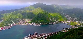
Pago Pago is the capital of American Samoa. It is in Maoputasi County on Tutuila, which is American Samoa's main island.
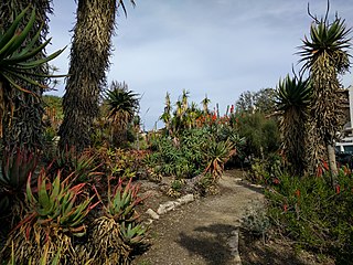
The Mildred E. Mathias Botanical Garden is a 7-acre (2.8 ha) botanical garden with over 3,000 species of plants, located on the southeastern corner of the University of California, Los Angeles (UCLA) campus. It is named after Mildred Esther Mathias Hassler (1906–1995), a noted American botanist. The director is Victoria Sork. It is also the only free public botanical garden in the Greater Los Angeles area.

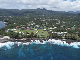
Tutuila is the largest and most populous island of American Samoa and is part of the archipelago of the Samoan Islands. It is the third largest island in the Samoan Islands chain of the Central Pacific. It is located roughly 4,000 kilometers (2,500 mi) northeast of Brisbane, Australia and lies over 1,200 kilometers (750 mi) to the northeast of Fiji. It contains a large, natural harbor, Pago Pago Harbor, where Pago Pago, the capital of American Samoa, is situated. Pago Pago International Airport is also located on Tutuila. The island's land expanse is about 68% of the total land area of American Samoa. With 56,000 inhabitants, it is also home to 95% of the population of American Samoa. The island has six terrestrial and three marine ecosystems.

Fagatogo is the downtown area of Pago Pago. Located in the low grounds at the foot of Matafao Peak, it was the location of the first American settlement on Tutuila Island. It includes the sub-village of Malaloa. Today, Fagatogo is the government, commercial, financial, and shipping center of Tutuila. It is also the administrative capital of American Samoa. It is the location of the American Samoa Fono (legislature), and is listed in the Constitution of American Samoa as the territory's official seat of government. Its population is 1,737.
Poloa is a village in American Samoa. It is located at the west side of Tutuila in the Alataua District. The village has 193 residents in 2010. The main denominations in the area are Methodist and Christian. Poloa has one elementary school. It is located in Lealataua County.
Utulei or ʻUtulei is a village in Maoputasi County, in the Eastern District of Tutuila, the main island of American Samoa. Utulei is traditionally considered to be a section of Fagatogo village, the legislative capital of American Samoa, and is located on the southwest edge of Pago Pago Harbor. Utulei is the site of many local landmarks: The A. P. Lutali Executive Office Building, which is next to the Feleti Barstow Library; paved roads that wind up to a former cablecar terminal on Solo Hill; the governor's mansion, which sits on Mauga o Alii, overlooking the entrance to Goat's Island, and the lieutenant governor's residence directly downhill from it; the Lee Auditorium, built in 1962; American Samoa's television studios, known as the Michael J. Kirwan Educational Television Center; and the Rainmaker Hotel. Utulei Terminal offers views of Rainmaker Mountain.
Aūa is a village on Tutuila Island in American Samoa. It is located along American Samoa Highway 001, and is the southern terminus of American Samoa Highway 006. Aūa is located at the foothills of Mount Peiva on the eastern shore of Pago Pago Bay. The hamlet of Leloaloa is also a part of Aūa.

Leone is the second-largest city on Tutuila Island's west coast. The village is on the south-west coast of Tutuila Island, American Samoa. Leone was the ancient capital of Tutuila Island. Leone was also where the Samoan Islands’ first missionary, John Williams, visited on October 18, 1832. A monument in honor of Williams has been erected in front of Zion Church. Its large church was the first to be built in American Samoa. It has three towers, a carved ceiling and stained glass. Until steamships were invented, Leone was the preferred anchorage of sailing ships which did not risk entering Pago Pago Harbor. Much early contact between Samoans and Europeans took place in Leone.
Nu'uuli is a village on the central east coast of Tutuila Island, American Samoa. It is located on a peninsula several miles up from Pago Pago International Airport. Nu’uuli is located between Pago Pago International Airport and Coconut Point. It is a shopping district which is home to stores such as South Pacific Traders, Nu’uuli Shopping Center, Aiga Supermarket and many more shops.
ʻAmanave is a village on the coast of Tutuila Island, American Samoa. It is located close to the island's western tip, Cape Taputapu, and to the south of the village of Poloa. It is located in Lealataua County.
Alofau is a village on the southeast coast of Tutuila Island, American Samoa. It is located at the eastern end of Faga'itua Bay, six miles east of Pago Pago, between Pagai and Amouli. It is home to Alofau Village Marine Protected Area. It is an agrarian and traditional village. It is also a poor village with residents with low literacy and high unemployment rates. As of the U.S. Census 2000, the per capita income was $4,357 and 67 percent of children were below the poverty line. 15.6 percent of residents were receiving public assistance. It is lauded as a kava place in the Manu'a Songs. Alofau is located in Sa'Ole County.
Asili is a village on the southwest coast of Tutuila Island, American Samoa. It is located between Leone and 'Amanave. It is located in Lealataua County.
Atu'u is a village on Tutuila Island, American Samoa. It is located on the coast of Pago Pago Harbor, close to the capital, Pago Pago.
Fagaʻalu is a village in central Tutuila Island, American Samoa. It is also known as Fagaʻalo. It is located on the eastern shore of Pago Pago Harbor, to the south of Pago Pago. American Samoa's lone hospital, Lyndon B. Johnson Tropical Medical Center, is located in Fagaʻalu. The village is centered around Fagaalu Stream.
Futiga is a village in the southwest of Tutuila Island, American Samoa. It is located inland, 7 miles (11 km) southwest of Pago Pago, between the villages of 'Ili'ili and Puapua. It is in Tualatai County.
Vailoatai is a village in southwestern Tutuila, the main island of American Samoa. It is located on the eastern end of Leone Bay. The village is known for its beautiful malae, nested along the island's rugged southern coast and lined by the fale tali mālō of its village chiefs.

Vatia is a village on Tutuila Island in American Samoa. It is a north shore village located on Vatia Bay. The road to Vatia, American Samoa Highway 006, is the only road going through National Park of American Samoa. Vatia is a scenic community at the foot of Pola Ridge and surrounded by the national park. It is only reached by Route 6 which traverses the national park before reaching Vatia. There was once a hiking trail over Maugaloa Ridge from Leloaloa, but since the completion of Route 6, this trail is now overgrown. It is home to a beach, and panoramic views of jungle-covered peaks surround the village on all sides. Vatia is the center of the Tutuila-section of National Park of American Samoa. It is located in Vaifanua County.
Taputimu is a village in southwestern Tutuila Island in American Samoa. It is the nearest village to the Fagatele Bay National Marine Sanctuary, although the main access is from the neighboring village of Futiga. It is home to Leala Shoreline National Natural Landmark and Leala Sliding Rock. Leala Sliding Rock is a natural rock formation between Vailoatai and Taputimu, which is a scenic landmark as well as a natural playground or slide. It was created by the ebb and flow of the ocean; the erosion has created a smooth shoreline site. It is located in Tualatai County in the Western District of Tutuila.
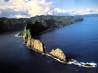
Pola Island is an island just offshore from the village of Vatia on Tutuila Island in American Samoa. It is also known as Cockscomb. Pola Island is designated as part of the National Park American Samoa, and is a popular tourist attraction. It is located on the west side of Vatia Bay, and serves as both a landmark and an icon for Vatia. Pola Island has been named one of American Samoa's Seven National Wonders by the Pago Pages. It has been named "the most beautiful natural feature of Tutuila Island” by travel guide publisher Lonely Planet. Pola Island is known for its high cliffs, populated by seabirds, and is one of American Samoa's primary seabird nesting sites.
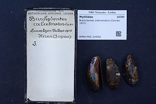
Brachidontes crebristriatus, also known as the Hawaiian mussel, nahawele liʻiliʻi or kio-nawahele, is a bivalve known only from Hawaiʻi.
