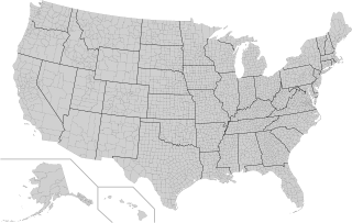
In the United States, a county or county equivalent is an administrative or political subdivision of a state which consists of a geographic region with specific boundaries and usually some level of governmental authority. The term "county" is used in 48 states, while Louisiana and Alaska have functionally equivalent subdivisions called parishes and boroughs, respectively. The specific governmental powers of counties vary widely between the states, with many providing some level of services to civil townships, municipalities, and unincorporated areas. Certain municipalities are in multiple counties; New York City is uniquely partitioned into five counties, referred to at the city government level as boroughs. Some municipalities have been consolidated with their county government to form consolidated city-counties, or have been legally separated from counties altogether to form independent cities. Conversely, those counties in Connecticut, Rhode Island, eight of Massachusetts's 14 counties, and Alaska's Unorganized Borough have no government power, existing only as geographic distinctions.

Territories of the United States are sub-national administrative divisions overseen by the federal government of the United States. The various American territories differ from the U.S. states and Indian reservations as they are not sovereign entities. In contrast, each state has a sovereignty separate from that of the federal government and each federally recognized Native American tribe possesses limited tribal sovereignty as a "dependent sovereign nation." Territories are classified by incorporation and whether they have an "organized" government through an organic act passed by the Congress. American territories are under American sovereignty and, consequently, may be treated as part of the United States proper in some ways and not others. Unincorporated territories in particular are not considered to be integral parts of the United States, and the Constitution of the United States applies only partially in those territories.

Swains Island is a remote coral atoll in the Tokelau Islands in the South Pacific Ocean. The island is the subject of an ongoing territorial dispute between Tokelau and the United States, which has administered it as part of American Samoa since 1925. Privately owned by the family of Eli Hutchinson Jennings since 1856, Swains Island was used as a copra plantation until 1967. It has not been permanently inhabited since 2008 but has often been visited by members of the Jennings family, scientific researchers, and amateur radio operators.
Samoan Americans are Americans of Samoan origin, including those who emigrated from the United States Territory of American Samoa and immigrants from the Independent State of Samoa to the United States. Samoan Americans are Pacific Islanders in the United States Census, and are the second largest Pacific Islander group in the U.S., after Native Hawaiians.
Pacific Islander Americans are Americans who are of Pacific Islander ancestry. For its purposes, the United States census also counts Aboriginal Australians as part of this group.

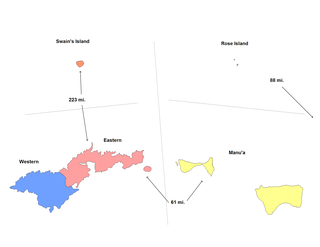
The Eastern District is one of the primary districts of American Samoa. It consists of the eastern portion of Tutuila, American Samoa's largest island, plus the island of Aunu'u. The district has a land area of 67.027 km2 and a 2010 census population of 23,030. It contains 34 villages plus a portion of Nu'uuli village. Among these are Pago Pago, Fagatogo, and Utulei.

The Western District is one of the three primary divisions of American Samoa. It consists of the western portion of Tutuila Island. It has a land area of 74.781 km2 and contains 29 villages plus a part of Nu'uuli village. Among these is the largest village of American Samoa, Tafuna, at its eastern end. The district's total population as of the 2010 census was 31,329.

American Samoa is administratively divided into three districts and two unorganized atolls. The districts are subdivided into 15 counties, which are composed of 76 villages.

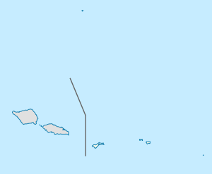
American Samoa is an unincorporated territory of the United States located in the South Pacific Ocean, southeast of the island country of Samoa. Centered on 14.3°S 170.7°W, it is east of the International Date Line and the Wallis and Futuna Islands, west of the Cook Islands, north of Tonga, and some 500 kilometers (310 mi) south of Tokelau. American Samoa is the southernmost territory of the United States and one of two U.S. territories south of the Equator, along with the uninhabited Jarvis Island.
Afao is a village in southwest Tutuila Island, American Samoa. It is located on the island's short southwestern coast, between 'Amanave and Leone, to the southwest of Pago Pago. It includes the settlement of Atauloma. Afao is home to two places listed on the U.S. National Register of Historic Places: Afao Beach Site and Atauloma Girls School.

The Manuʻa District is one of the three primary administrative divisions of American Samoa. The district comprises the Manuʻa Islands, which are located approximately 61 miles east of the main island, Tutuila. The Manuʻa District is considered to be a county-equivalent by the U.S. Census Bureau.

Amata Catherine Coleman Radewagen, commonly called Aumua Amata, is an American Samoan politician who is the current delegate for the United States House of Representatives from American Samoa. Radewagen, a Republican, was elected on November 4, 2014, after defeating Democratic incumbent Eni Faleomavaega; she was the first-ever Republican delegate since the office had been created in 1970 and began her tenure on January 3, 2015. She also serves as the national committeewoman for the Republican Party of American Samoa. Amata is the first woman to represent American Samoa in the U.S. Congress.

Maʻopūtasi County is located in the Eastern District of Tutuila Island in American Samoa. Maʻopūtasi County comprises the capital of Pago Pago and its harbor, as well as surrounding villages. It was home to 11,695 residents as of 2000. Maʻopūtasi County is 6.69 square miles (17.3 km2) The county has a 7.42-mile (11.94 km) shoreline which includes Pago Pago Bay.
Suʻa County is a county in the Eastern District in American Samoa. Su'a County contains the villages of Afono, Fagaitua, Falefa, Lauli'i, Masefau, Masausi and Sailele. The county had a population of 3,323 as of the 2010 U.S. Census. According to the Constitution of American Samoa, Sua County is represented by two senatorial seats in the American Samoa Senate.


