Related Research Articles

Victoria is the capital city of the Canadian province of British Columbia, on the southern tip of Vancouver Island off Canada's Pacific coast. The city has a population of 91,867, and the Greater Victoria area has a population of 397,237. Victoria is the 7th most densely populated city in Canada with 4,405.8 inhabitants per square kilometre (11,411/sq mi).

Bowen Island, British Columbia, is an island municipality that is part of Metro Vancouver. Bowen Island is within the jurisdiction of the Islands Trust. Located in Howe Sound, it is approximately 6 kilometres (3.7 mi) wide by 12 kilometres (7.5 mi) long, with the island at its closest point about 3 kilometres (1.9 mi) west of the mainland. There is regular ferry service from Horseshoe Bay, as well as semi-regular water taxi services. The population of 3,680 is supplemented in the summer by roughly 1,500 visitors, as Bowen Island regularly receives travelers in the summer season. The island has a land area of 49.94 km2.

New Westminster is a city in the Lower Mainland region of British Columbia, Canada, and a member municipality of the Metro Vancouver Regional District. It was founded by Major-General Richard Moody as the capital of the new-born Colony of British Columbia in 1858, and continued in that role until the Mainland and Island Colonies were merged in 1866. It was the British Columbia Mainland's largest city from that year until it was passed in population by Vancouver during the first decade of the 20th century.

West Vancouver is a district municipality in the province of British Columbia, Canada. A member municipality of the Metro Vancouver Regional District, West Vancouver is to the northwest of the city of Vancouver on the northern side of English Bay and the southeast shore of Howe Sound, and is adjoined by the District of North Vancouver to its east. Together with the District of North Vancouver and the City of North Vancouver, it is part of a local regional grouping referred to as the North Shore municipalities, or simply "the North Shore".

Harbourfront is a neighbourhood on the northern shore of Lake Ontario within the downtown core of the city of Toronto, Ontario, Canada. Part of the Toronto waterfront, Harbourfront extends from Bathurst Street in the west, along Queens Quay, with its ill-defined eastern boundary being either Yonge Street or York Street. Its northern boundary is the Gardiner Expressway. Much of the district was former water lots filled in during the early 1900s to create a larger harbour district. After shipping patterns changed and the use of the Toronto harbour declined, the area was converted from industrial uses to a mixed-use district that is mostly residential and leisure.

Greater Victoria is located in British Columbia, Canada, on the southern tip of Vancouver Island. It is a cultural rather than political entity, usually defined as the thirteen easternmost municipalities of the Capital Regional District (CRD) on Vancouver Island as well as some adjacent areas and nearby islands.
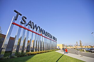
Tsawwassen is a suburban, mostly residential community on a peninsula in the southwestern corner of the City of Delta in British Columbia, Canada. It provides the only road access to the American territory on the southern tip of the peninsula, the community of Point Roberts, Washington, via 56th Street. It is also the location of Tsawwassen Ferry Terminal, part of the BC Ferries, built in 1959 to provide foot-passenger and motor vehicle access from the Lower Mainland to the southern part of Vancouver Island and the southern Gulf Islands. Because Tsawwassen touches a shallow bank, the ferry terminal is built at the southwestern end of a 3 km (1.9 mi) causeway that extends into the Strait of Georgia. Boundary Bay Airport, a major training hub for local and international pilots which also provides local airplane and helicopter service, is ten minutes away. The Roberts Bank Superport is also nearby.

False Creek is a short narrow inlet in the heart of Vancouver, separating the Downtown and West End neighbourhoods from the rest of the city. It is one of the four main bodies of water bordering Vancouver, along with English Bay, Burrard Inlet and the Fraser River. Granville Island is located within the inlet.
The North Shore is a term commonly used to refer to several areas adjacent to Vancouver, British Columbia, Canada:

The District of North Vancouver is a district municipality in British Columbia, Canada, and is part of Metro Vancouver. It surrounds the City of North Vancouver on three sides. As of 2016, the District stands as the second wealthiest city in Canada, with neighbouring West Vancouver the richest. The municipality is largely characterized as being a relatively quiet, affluent suburban hub home to many middle and upper-middle-class families. Homes in the District generally range from mid-sized family bungalows to very large luxury houses. A number of dense multi-family and mixed-use developments have popped up across the district in recent years; however, the District remains a primarily suburban municipality. The District is served by the Royal Canadian Mounted Police, British Columbia Ambulance Service, and the District of North Vancouver Fire Department.

Ladner is a part of the City of Delta, British Columbia, Canada, and a suburb of Vancouver, British Columbia. It was created as a fishing village on the banks of the Fraser River.
Hastings–Sunrise is a neighbourhood located in the northeastern corner of the city of Vancouver, British Columbia.
The District Municipality of Sechelt is located on the lower Sunshine Coast of British Columbia. Approximately 50 km northwest of Vancouver, it is accessible from mainland British Columbia by a 40-minute ferry trip between Horseshoe Bay and Langdale, and a 25-minute drive from Langdale along Highway 101, also known as the Sunshine Coast Highway. The name Sechelt is derived from the Sechelt language word, shishalh, the name of the First Nations people who first settled the area thousands of years ago.

Downtown Vancouver is the main central business district and the city center neighbourhood of Metro Vancouver, located on the northwestern shore of the Burrard Peninsula in the Lower Mainland region of British Columbia. The Downtown occupies most of the north shore of the False Creek inlet, which incises into the Burrard Peninsula creating the namesaked Downtown Peninsula, where the West End neighbourhood and Stanley Park are also located.

Riley Park–Little Mountain is a neighbourhood in Vancouver, British Columbia. Its boundaries are 41st Avenue to the south, 16th Avenue to the north, Cambie Street to the west, and Fraser Street to the east. The main commercial thoroughfare of the neighbourhood is Main Street.

Renfrew–Collingwood is a large neighbourhood that lies on the eastern side of Vancouver, British Columbia, Canada, on its boundary with Burnaby and encompassing an area that was one of the earlier developed regions of the city. It is a diverse area that includes a substantial business community in several areas, as well as some of the fastest-growing residential sectors of Vancouver. In 2011, the neighbourhood had a population of 50,500, 38.4% of whom claim Chinese as their first language.
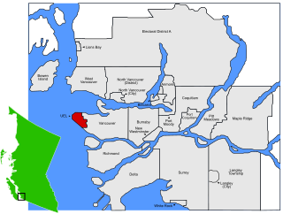
The University Endowment Lands (UEL) is an unincorporated area that lies to the west of the city of Vancouver, British Columbia, Canada, and adjacent to the University of British Columbia and the lands associated with that campus. Pacific Spirit Regional Park lies within the UEL. The UEL is part of Metro Vancouver. Mail sent to the UEL is addressed to "Vancouver" rather than the UEL.
Dundarave is a neighbourhood in West Vancouver, British Columbia, Canada. It occupies the central-eastern portion of West Vancouver's beachfront. It is bordered by Ambleside to the east and West Bay to the west.
Nanaimo Harbour, also known as the Port of Nanaimo, is a natural harbour on the east coast of Vancouver Island, British Columbia, Canada. The City of Nanaimo runs along the west side of the harbour. Three islands, Newcastle, Protection, and Gabriola, along with Duke Point, form the eastern edge. The Port of Nanaimo includes the Inner Harbour, Nanaimo River estuary, Departure Bay, the waters on the east side of Newcastle and Protection Islands, and Northumberland Channel. The port is under the management of the Nanaimo Port Authority.
Marine Drive is the name for three major roadways in Greater Vancouver, British Columbia, Canada. The roads are known for running parallel to major bodies of water, with some sections being a major arterial road, while other serve local traffic. Marine Way is the name applied to a section of Marine Drive that was bypassed in the early 1980s.
References
- ↑ West Van presents new Ambleside proposals: Public reaction to ideas encouraged by council: Altmayer, Darren. North Shore News; North Vancouver, B.C. 17 Feb 2006: 3.
- 1 2 3 Hendrigan, Cole Evan (2006). Ambleside : better living by the water (Thesis). University of British Columbia. doi:10.14288/1.0092980.
- ↑ "Historic timeline". westvancouverite. Retrieved 2022-06-23.
- ↑ "Ambleside Amble". Inside Vancouver. 2017-11-21. Retrieved 2022-06-23.
- ↑ "West Vancouver's Ambleside: then and now". Eve Lazarus. 2017-07-22. Retrieved 2022-06-23.
Coordinates: 49°19′42″N123°09′24″W / 49.328298°N 123.156729°W