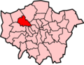
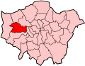
It is the site of the largest business park in London,[1] but despite intensive existing use, the area is, together with adjacent Old Oak Common, intended to become the UK's largest regeneration scheme.[2] This arises from the area's relatively central location and also the strong and improving transport links which will include (at Old Oak Common), HS2 and the Elizabeth line. The scale of redevelopment has led to the Park Royal and Old Oak area being described as a potential "Canary Wharf of West London".[3][4]
The Grand Union Canal runs through the middle of the Park Royal industrial estate, with pedestrian access via the towpath.
History
The name Park Royal derives from the short-lived showgrounds opened in 1903 by the Royal Agricultural Society as a permanent exhibition site for the society's annual show. After only three years the society sold the site, and returned to a touring format for its shows. With its road, rail and canal links, Park Royal was subsequently developed for industrial use, mainly during the 1930s.
Queens Park Rangers F.C. played on two grounds in Park Royal. The first was the Horse Ring, later the site of the Guinness brewery, which had a capacity of 40,000. When the Royal Agricultural Society sold the grounds in 1907, QPR moved to the Park Royal Ground, 400 yards (370m) south, an almost exact replica of Ayresome Park, with a capacity of 60,000. The club was forced to move out in February 1915 as the ground was taken over by the Army.[6]
On 12 December 1908, the first ever rugby league test match between Great Britain (playing as the Northern Union) and Australia took place at the Park Royal Ground in front of 2,000 fans. The match ended in a 22-all draw and was played as part of the first everKangaroo Tour.[7]
The Guinness Brewery opened in 1936. It was designed by Sir Giles Gilbert Scott and Alexander Gibb. The Guinness company built homes for its workers in the surrounding area, naming the streets after people and places connected with the Guinness family, such as Iveagh Avenue and Moyne Place. The Brewery buildings were demolished in 2006.[8]
It is the site of the largest business park in London, occupying about 1,200 acres (490ha).[1] Park Royal business park has over 1,200 businesses, employing an estimated 35,000 workers.[10] Approximately 500 food companies operate at Park Royal, employing more than 14,000 people.[11]
Park Royal also has areas of residential housing and amenities serving them. Park Royal Business Park is promoted commercially by the Park Royal Partnership, which is part of West London Business.
On the southern side beyond the arterial Western Avenue (A40), which leads to the Hanger Lane Gyratory System, is the Royale Leisure Park, which contains a cinema (which closed in June 2020), restaurants, arcade and a bowling alley. There is also a B&Q superstore, Renault and Nissan Car Dealerships, a Staples Superstore and other industrial buildings comprising the southern half of Park Royal.[citation needed]
As well as many small industrial firms, Park Royal is the location of some large company buildings, including McVities[12] and Heinz. The old Guinness brewery and sports ground site at the south-western extremity of the district has now been demolished, however the rail sidings are still in use for aggregate freight traffic supplying the Lafarge Tarmac depot. The first building erected adjacent to the new roundabout and bridge link to Western Avenue is occupied by international drinks company Diageo, owner of the Guinness brand and the redevelopment site. The Female Health Company, which manufactures Femidoms, has one of its two manufacturing plants here, too.[citation needed]
Royale Leisure Park
It is public policy to maintain Park Royal as predominantly a business area. It is designated as an Opportunity Area, and in 2008 the Mayor of London's office published a draft Planning Framework which aspires to maintain, "growing economic clusters of food/drink, transport/logistics and television/film."[13] The framework does not preclude use of parts of the site for housing.
In summer 2011, the London Borough of Hammersmith and Fulham launched a Park Royal City plan for Old Oak Common, based around the immediate eastern border of North Acton, including light-rail lines to nearby areas.[14]
↑"'Acton: Economic history'". A History of the County of Middlesex: Volume 7: Acton, Chiswick, Ealing and Brentford, West Twyford, Willesden (1982), pp. 23-30. Victoria County History. Retrieved 8 October 2007.
↑"Archived copy". Archived from the original on 24 June 2007. Retrieved 18 December 2005.{{cite web}}: CS1 maint: archived copy as title (link) CS1 maint: bot: original URL status unknown (link)unitedbiscuits.com
This page is based on this Wikipedia article Text is available under the CC BY-SA 4.0 license; additional terms may apply. Images, videos and audio are available under their respective licenses.