Northolt Manor

Last updated
Northolt Manor moat Northolt Manor House moat.JPG
Northolt Manor moat

Northolt Manor is a 1.8 hectare scheduled monument, local nature reserve and Site of Borough Importance for Nature Conservation, Grade II, in Northolt in the London Borough of Ealing. It is owned and managed by Ealing Council. [1] [2] [3]

Archaeological excavations from 1950 show that the site has been occupied since at least the 7th to early 8th centuries. [4] Around 1300 a moat was dug, and later in the century the first stone buildings were erected to make a moated manor house. It was demolished in the eighteenth century. In 1935 the land was purchased by the local authority for public open space. [5]

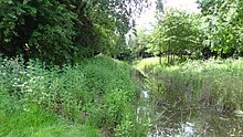
The site has meadows, scrub, woodlands, wetlands and ponds. There is access from Court Farm Road. [1]

Related Research Articles

<span class="mw-page-title-main">Northolt</span> Area of London

Northolt is a town in West London, England, spread across both sides of the A40 trunk road. It is 11 mi (17.7 km) west-northwest of Charing Cross and is one of the seven major towns that make up the London Borough of Ealing. It had a population of 30,304 at the 2011 UK census.

<span class="mw-page-title-main">South Norwood Country Park</span>

South Norwood Country Park is a park in South Norwood, close to Elmers End and Birkbeck train stations. The historic Kent-Surrey border runs through the site, and since 1965 it has been located wholly in the London Borough of Croydon. It is a 47 hectare green space which opened in 1989. The park is a mix of countryside and parkland, and land formerly used for sewage farms serving the growing London population.

<span class="mw-page-title-main">Elthorne Hundred</span>

Elthorne was a hundred of the historic county of Middlesex, England.

<span class="mw-page-title-main">Stanmore Country Park, London</span>

Stanmore Country Park is a 30.7-hectare (76-acre) public park, Local Nature Reserve and Site of Metropolitan Importance for Nature Conservation in Stanmore in the London Borough of Harrow. It is owned and managed by Harrow London Borough Council.

<span class="mw-page-title-main">Ruislip Woods</span> Woodland in Ruislip, London

Ruislip Woods is a Site of Special Scientific Interest and national nature reserve covering 726 acres (294 ha) in Ruislip in the London Borough of Hillingdon. The woods became London's first national nature reserve in May 1997. Ruislip Local Nature Reserve at TQ 090 899 is part of the national nature reserve.

<span class="mw-page-title-main">Rowley Green Common</span>

Rowley Green Common is a six hectare Local Nature Reserve and a Site of Importance Metropolitan for Nature Conservation in Arkley, north London. It is owned by the London Borough of Barnet. It is also registered common land.

<span class="mw-page-title-main">Litten Nature Reserve</span> Nature reserve in London, England

Litten Nature Reserve is 1 hectare a Site of Borough Importance for Nature Conservation, Grade II, and Local Nature Reserve in Greenford in the London Borough of Ealing. It is owned and managed by Ealing Council.

<span class="mw-page-title-main">Grove Farm, Ealing</span>

Grove Farm is an 8-hectare Local Nature Reserve (LNR) in Greenford in the London Borough of Ealing. It was declared an LNR in 2002 by Ealing Council, which owns and manages the site.

<span class="mw-page-title-main">Ravensbury Park</span>

Ravensbury Park is a public park in Mitcham in the London Borough of Merton. An area of 7 hectares is designated a Local Nature Reserve. The River Wandle runs along the southern boundary of the park, which is also part of the Upper Wandle River Site of Metropolitan Importance for Nature Conservation.

<span class="mw-page-title-main">Sir Joseph Hood Memorial Wood</span>

Sir Joseph Hood Memorial Wood is a 1.7 hectare Local Nature Reserve and a Site of Borough Importance for Nature Conservation, Grade I, in Motspur Park in the London Borough of Merton. It adjoins Sir Joseph Hood Memorial Playing Fields, and both are owned and managed by Merton Council.

Hogsmill River Park or Hogsmill Valley is a linear park along the banks of the Hogsmill River in the Royal Borough of Kingston upon Thames in London. It stretches from the junction of Surbiton Hill Park and Elmbridge Avenue in Berrylands in the north to the junction between the river and a footpath to Manor Close in Old Malden in the south.

<span class="mw-page-title-main">Southwood Open Space</span>

Southwood Open Space is a 12.9 hectare Local Nature Reserve (LNR) in Old Malden in the Royal Borough of Kingston upon Thames in London. It is a linear park along the Hogsmill River between the Kingston Bypass opposite Elmbridge Avenue and the junction between the Hogsmill and a footpath to Manor Drive North.

<span class="mw-page-title-main">Blondin Park</span>

Blondin Park is an 8.5-hectare (21-acre) public park in Northfields in the London Borough of Ealing. It has allotments area and sports pitches. It is owned by Ealing Council and managed by the Council together with the Friends of Blondin Park. An area of 2.3 ha in the south-west corner is a Local Nature Reserve, and the nature area and allotments are a Site of Local Importance for Nature Conservation.

<span class="mw-page-title-main">Long Wood, Ealing</span>

Long Wood is a 1.2 hectare Local Nature Reserve and Site of Borough Importance for Nature Conservation, Grade 1, in Norwood Green in the London Borough of Ealing. It is owned and managed by Ealing Council.

<span class="mw-page-title-main">Fox Wood</span>

Fox Wood is a 2.25 hectare Local Nature Reserve and Site of Borough Importance for Nature Conservation, Grade 1, in Ealing in the London Borough of Ealing. It is owned and managed by Ealing Council.

<span class="mw-page-title-main">Islip Manor Meadows</span>

Islip Manor Meadows is a 23.75 hectare Local Nature Reserve and Site of Metropolitan Importance for Nature Conservation in Northolt in the London Borough of Ealing. It is owned and managed by Ealing Council.

<span class="mw-page-title-main">Yeading Brook Meadows</span>

Yeading Brook Meadows is a 17 hectare Local Nature Reserve (LNR) in Yeading in the London Borough of Hillingdon. It is owned by Hillingdon Council and managed by the London Wildlife Trust (LWT). In the north it adjoins Ten Acre Wood across the Golden Bridge and Charville Lane; it then stretches south along the banks of the Yeading Brook to Yeading Lane. The reserve is also part of the Yeading Brook Meadows Site of Metropolitan Importance for Nature Conservation, which includes two neighbouring LNRs managed by the London Wildlife Trust, Ten Acre Wood and Gutteridge Wood and Meadows.

<span class="mw-page-title-main">Down Barns Moated Site</span>

Down Barns Moated Site is a Scheduled Ancient Monument in Northolt in the London Borough of Ealing. It is the site of a medieval manor house, which does not survive, but the moat does. It was probably in existence by 1388, and is thought to have been abandoned in the sixteenth century. Excavations were undertaken in the 1950s and 1960s, but the results are not known. Pottery previously excavated here was originally identified as Saxon, but now thought to be prehistoric.

<span class="mw-page-title-main">Mowsbury Hill</span>

Mowsbury Hill is a 2.8 hectare Local Nature Reserve and Scheduled Monument in north Bedford. It is owned and managed by Bedford Borough Council with the assistance of the Friends of Putnoe Wood and Mowsbury Hillfort.

References

  1. 1 2 "Northolt Manor". Local Nature Reserves. Natural England. 6 March 2013. Retrieved 24 May 2014.
  2. "Map of Northolt Manor". Local Nature Reserves. Natural England. Retrieved 24 May 2014.
  3. "Northolt Manor and Belvue Park". Greenspace Information for Greater London. 2013. Archived from the original on 22 October 2013. Retrieved 24 May 2014.
  4. The archaeology of Greater London : an assessment of archaeological evidence for human presence in the area now covered by Greater London. [London]: Museum of London Archaeology Service. 2000. ISBN   1-901992-15-2.
  5. Baker, T. F. T.; et al. (1971). "A History of the County of Middlesex: Volume 4: Harmondsworth, Hayes, Norwood with Southall, Hillingdon with Uxbridge, Ickenham, Northolt, Perivale, Ruislip, Edgware, Harrow with Pinner". British History Online. Institute of Historical Research. pp. 113–116. Retrieved 24 May 2014.

Coordinates: 51°32′40″N0°22′08″W / 51.5444°N 0.3690°W / 51.5444; -0.3690