
Carshalton is a town, with a historic village centre, in south London, England, within the London Borough of Sutton. It is situated 9.5 miles (15.3 km) south-southwest of Charing Cross, in the valley of the River Wandle, one of the sources of which is Carshalton Ponds in the middle of the village. Prior to the creation of Greater London in 1965, Carshalton was in the administrative county of Surrey.

The London Borough of Southwark in South London forms part of Inner London and is connected by bridges across the River Thames to the City of London and London Borough of Tower Hamlets. It was created in 1965 when three smaller council areas amalgamated under the London Government Act 1963. All districts of the area are within the London postal district. It is governed by Southwark London Borough Council.
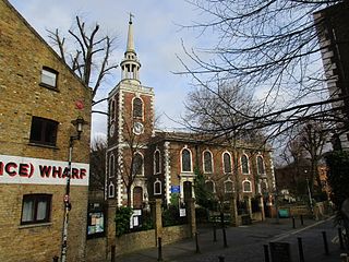
Rotherhithe is a district of south-east London, England, and part of the London Borough of Southwark. It is on a peninsula on the south bank of the Thames, facing Wapping, Shadwell and Limehouse on the north bank, as well as the Isle of Dogs to the east of the Thames and is a part of the Docklands area. It borders Bermondsey to the west and Deptford to the south east.

The Surrey Commercial Docks were a large group of docks in Rotherhithe, South East London, located on the south bank of the River Thames.

Surrey Docks is a largely residential area of Rotherhithe in south-east London, occupied until 1970 by the Surrey Commercial Docks.. The precise boundaries of the area are somewhat amorphous, but it is generally considered to comprise the southern half of the Rotherhithe peninsula from Canada Water to South Dock; electorally, Surrey Docks is the eastern half of the peninsula. The area is served by Surrey Quays railway station. The Docks are called Surrey Docks because until 1889 the borders of Surrey and Kent met in this area.
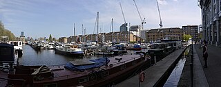
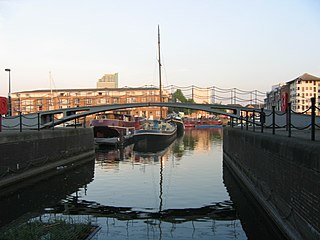
Greenland Dock is the oldest of London's riverside wet docks, located in Rotherhithe in the area of the city now known as Docklands. It used to be part of the Surrey Commercial Docks, most of which have by now been filled in. Greenland Dock is now used purely for recreational purposes; it is one of only two functioning enclosed docks on the south bank of the River Thames, along with the smaller South Dock, to which it is connected by a channel now known as Greenland Cut.

Surrey Wildlife Trust (SWT) was founded in 1959 as Surrey Naturalists' Trust and it is one of forty-six wildlife trusts covering Great Britain, Northern Ireland, Isle of Man and Alderney. SWT carries out conservation activities on a considerable area of Surrey County Council's large countryside estate and also manages land on behalf of the Ministry of Defence estate. As of 2022 the SWT manages more than 6,000 hectares of land for wildlife and employs more than 100 staff. It had an income of £5.1 million and expenditure of £5.7 million.
South Dock is one of two surviving docks in the former Surrey Commercial Docks in Rotherhithe, London, England. It was built in 1807–1811 just south of the larger Greenland Dock, to which it is connected by a channel now known as Greenland Cut; it also has a lock giving access to the River Thames. Originally named the East Country Dock, it was renamed in 1850 when the Surrey Commercial Dock Company purchased and enlarged it. Timber and grain were the main products imported and exported in the dock.

Canada Water is an area of the Docklands in south-east London. It is named after a freshwater lake and wildlife refuge. Canada Water tube, Overground and bus station is immediately north of the lake, along with Canada Water Library which overhangs the lake and Deal Porter Square. Surrey Quays Shopping Centre is also adjacent, sitting immediately to the south. The surrounding area, which forms the town centre of Rotherhithe, is now increasingly known as Canada Water, after the transport interchange as much as the lake itself.
The Grand Surrey Canal was a canal constructed in south London, England during the early 19th century. It opened to the Old Kent Road in 1807, to Camberwell in 1810, and to Peckham in 1826. Its main purpose was to transport cargo, primarily timber from the Surrey Commercial Docks.

The London Borough of Southwark, occupying a roughly triangular area south of Tower Bridge over the River Thames, considers itself to be one of the greenest boroughs in London, with its 245 hectares of public parkland. There are more than 130 such green areas, ranging from the large areas around Dulwich and Southwark Park in Rotherhithe to the many sports grounds and squares. The main ones are:

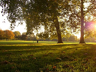
Russia Dock Woodland is a long narrow park in Rotherhithe, London, created by the infilling of one of the former Surrey Commercial Docks. The former Russia Dock was originally used for the importing of softwood timber from Norway, Russia and Sweden. Known as "deal wood", it was mostly used for newsprint and for manufacturing furniture.

Camley Street Natural Park is an urban nature reserve in St Pancras in central London and within the London Borough of Camden. It is a local nature reserve.
Southwark Park is located in Rotherhithe, in central South East London, England, and is managed by the London Borough of Southwark. It first opened in 1869 by the Metropolitan Board of Works as one of its first parks. It was designed by Alexander McKenzie and covers 63 acres (250,000 m2). It takes its name from being in what was the old Parliamentary constituency of Southwark at the time of its opening.

Railway Fields is a Local Nature Reserve and a Site of Borough Importance for Nature Conservation, Grade I, in Harringay the London Borough of Haringey. About one hectare in area, it was a railway goods yard until 1967.

Sydenham Hill Wood is a ten-hectare wood on the northern slopes of the Norwood Ridge in the London Borough of Southwark. It is designated as a Local Nature Reserve and Site of Metropolitan Importance for Nature Conservation. With the adjacent Dulwich Wood, Sydenham Hill Wood is the largest extant tract of the ancient Great North Wood. The two woods are formed from coppices known as Lapsewood, Old Ambrook Hill Wood and Peckarmans Wood after the relocation of The Crystal Palace in 1854 and the creation of the high level line in 1865.

Godstone Ponds is a 13.6-hectare (34-acre) biological Site of Special Scientific Interest in Godstone in Surrey. Bay Pond is an educational nature reserve closed to the public which is managed by the Surrey Wildlife Trust.

Lesnes Abbey Woods, sometimes known as Abbey Wood, is a 73 ha ancient woodland in southeast London, England. It is located near to, and named after, the ruined Lesnes Abbey in the London Borough of Bexley and gives its name to the Abbey Wood district. The woods are adjacent to Bostall Woods.

Gunnersbury Triangle is a 2.57-hectare (6.4-acre) local nature reserve in Chiswick, in the London boroughs of Ealing and Hounslow, immediately to the east of Gunnersbury. It was created in 1983 when, for the first time in Britain, a public inquiry ruled that a planned development of the land could not go ahead because of its value for nature. It opened as a nature reserve in 1985.

Cranham Marsh is a 15.3 hectare Local Nature Reserve and a Site of Metropolitan Importance for Nature Conservation in Cranham in the London Borough of Havering. It is owned by Havering Council and managed by the Essex Wildlife Trust.
