Ham Lands

Last updated

Ham Lands is a 72-hectare Local Nature Reserve and Site of Metropolitan Importance for Nature Conservation in Ham in the London Borough of Richmond upon Thames and the Royal Borough of Kingston upon Thames. The area is very popular with walkers, nature lovers, and horse-riders. There is an unofficial (non Council) off-road BMX track near Teddington Lock. [1] [2]

Contents

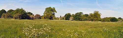
The site is a large area of grassland and scrub bordering the River Thames. The other boundary is mostly formed by Riverside Drive. The area is divided into two sections by the lagoon and Thames Young Mariners.

The land belonged to the Earl of Dysart until the nineteenth century. In 1904 it was leased by the Ham River Grit Co. Ltd for excavation of sand and ballast. They constructed a wharf and processing plant where barges loaded. A canal was constructed through the towpath in the 1920s to create an internal loading lagoon, now the Thames Young Mariners. The gravel pits were then backfilled with soil from different areas of London, creating a variety of habitats which attract many bird and butterfly species. By the 1960s tipping was complete and the Wates estate built along Riverside Drive. [3]

The construction of Teddington Lock in 1904, now the limit of the tidal Thames, resulted in the raising of the towpath while the in-filled area was above the general level of flooding. The area north of Thames Young Mariners is still floodable. The flood-meadows have a wide range of wild flowers [2] [4] and there are many plants which are rare in London. [1] Some of the more unusual plants found include meadow saxifrage, hemlock water-dropwort, yellow vetchling, hoary cinquefoil/silver cinquefoil, dittander/pepperwort, bee orchid, pyramidal orchid.

Plans to build on the former gravel pits were finally abandoned by the Council in 1983. A survey of the flora was carried out by Nigel Hepper in 1985 and a report published in 1987 which recognised eight zones. [3]


Related Research Articles

Richmond is a town in south-west London, 8.2 miles (13.2 km) west-southwest of Charing Cross. It is on a meander of the River Thames, with many parks and open spaces, including Richmond Park, and many protected conservation areas, which include much of Richmond Hill. A specific Act of Parliament protects the scenic view of the River Thames from Richmond.

<span class="mw-page-title-main">Borough of Spelthorne</span> Place in England

Spelthorne is a local government district and borough in Surrey, England. Its council is based in Staines-upon-Thames; other settlements in the area include Ashford, Sunbury-on-Thames, Shepperton, Stanwell and Laleham.

<span class="mw-page-title-main">Teddington Lock</span> Series of locks on the River Thames in London

Teddington Lock is a complex of three locks and a weir on the River Thames between Ham and Teddington in the London Borough of Richmond upon Thames, England. Historically in Middlesex, it was first built in 1810.

<span class="mw-page-title-main">Cotswold Water Park</span>

The Cotswold Water Park is the United Kingdom's largest marl lake system, straddling the Wiltshire–Gloucestershire border, northwest of Cricklade and south of Cirencester. There are 180 lakes, spread over 42 square miles (110 km2).

<span class="mw-page-title-main">Trowlock Island</span>

Trowlock Island is a residential island in the River Thames 450 metres (490 yd) upstream of Teddington Lock on the non-tidal Kingston reach less than 10 metres from the northern bank, in the London Borough of Richmond upon Thames, England.

<span class="mw-page-title-main">Ham, London</span> Area of Richmond in London, England

Ham is a suburban district in Richmond, south-west London. It has meadows adjoining the River Thames where the Thames Path National Trail also runs. Most of Ham is in the London Borough of Richmond upon Thames and, chiefly, within the ward of Ham, Petersham and Richmond Riverside; the rest is in the Royal Borough of Kingston upon Thames. The district has modest convenience shops and amenities, including a petrol station and several pubs, but its commerce is subsidiary to the nearby regional-level economic centre of Kingston upon Thames.

<span class="mw-page-title-main">Hampton Court Park</span>

Hampton Court Park, also known as Home Park, is a walled royal park managed by the Historic Royal Palaces. The park lies between the gardens of Hampton Court Palace and Kingston upon Thames and Surbiton in south west London, England, mostly within the post town of East Molesey, but with its eastern extremity within the post town of Kingston. In 2014, part of the park was designated a biological Site of Special Scientific Interest. It takes up most of the final (lowest) meander of the non-tidal reaches of the River Thames and is mainly divided between a golf course, meadows interspersed with trees used for deer, seasonal horse grazing and wildlife. A corner of the park is used annually for the Hampton Court Flower Show and the part nearest to the palace has the Long Water — an early set of hydro-engineered ponds or lakes, fed by water from the distant River Colne, as are the bodies of water in the neighbouring park, Bushy Park.

<span class="mw-page-title-main">Thames Path</span> National Trail following the River Thames in England

The Thames Path is a National Trail following the River Thames from its source near Kemble in Gloucestershire to the Woolwich foot tunnel, south east London. It is about 185 miles (298 km) long. A path was first proposed in 1948 but it only opened in 1996.

<span class="mw-page-title-main">Parks and open spaces in the London Borough of Newham</span>

The London Borough of Newham, in spite of being one of the more crowded areas of London, has over 20 parks within its boundaries, as well as smaller recreation grounds. The larger parks in the Borough include:

<span class="mw-page-title-main">Canbury Gardens</span> Park in Kingston upon Thames, London

Canbury Gardens is a public space in the Canbury district of Kingston upon Thames, along the Lower Ham Road, covering 14½ acres area between the road and the towpath along the River Thames, downstream from Kingston Railway Bridge.

<span class="mw-page-title-main">Teddington</span> Area of South West London, England

Teddington is a suburb in south-west London in the London Borough of Richmond upon Thames. In 2021, Teddington was named as the best place to live in London by The Sunday Times. Historically in Middlesex, Teddington is situated on a long meander of the Thames between Hampton Wick and Strawberry Hill, Twickenham. Mostly residential, it stretches from the river to Bushy Park with a long high street of shops, restaurants and pubs. There is a suspension bridge over the lowest non-tidal lock on the Thames, Teddington Lock. At Teddington's centre is a mid-rise urban development, containing offices and apartments.

<span class="mw-page-title-main">Rammey Marsh</span> Marshland in London

Rammey Marsh is located in the Lee Valley Park at Enfield Lock, Enfield, and covers approximately 42 hectares. The site is owned and managed by the Lee Valley Regional Park Authority.

<span class="mw-page-title-main">Ham Common, London</span>

Ham Common is an area of common land in Ham, London. It is a conservation area in, and managed by, the London Borough of Richmond upon Thames. It comprises 48.69 hectares, the second largest area of common land in the borough, 2 acres (0.81 ha) smaller than Barnes Common. It is divided into two distinct habitats, grassland and woodland, separated by the A307, Upper Ham Road. It is an area of ecological, historical and recreational interest, designated a Local Nature Reserve.

<span class="mw-page-title-main">Oak Avenue Local Nature Reserve</span>

Oak Avenue is a 1.85 hectare Local Nature Reserve and Grade II Site of Borough Importance for Nature Conservation in Hampton in the London Borough of Richmond upon Thames. It is owned and managed by Richmond upon Thames Borough Council.

<span class="mw-page-title-main">Irthlingborough Lakes and Meadows</span>

Irthlingborough Lakes and Meadows is a 117-hectare (290-acre) nature reserve in Northamptonshire, owned and managed by the Wildlife Trust for Bedfordshire, Cambridgeshire and Northamptonshire. The character of the reserve is defined by flooded gravel pits and wet grassland, providing an excellent habitat for large variety of wetland flora and fauna.

<span class="mw-page-title-main">Thames Young Mariners</span> Area of land in Ham, London

Thames Young Mariners is a 25-acre area of land situated in Ham. It includes the Thames Young Mariners Base Lagoon, which is a calm 10-acre lake connected to the River Thames by a lock. The site was established over 40 years ago and sits in between Richmond and Kingston.

<span class="mw-page-title-main">Arthur Jacob Nature Reserve</span>

Arthur Jacob Nature Reserve is a 4.1-hectare (10-acre) Local Nature Reserve in Horton in Berkshire. It is owned and managed by the Royal Borough of Windsor and Maidenhead.

<span class="mw-page-title-main">Petersham Meadows</span>

Petersham Meadows are a 24-acre water-meadow that lie alongside the River Thames in Petersham, London, bounded by Buccleuch Gardens, Manor Farm Livery Stables, the main Petersham Road (A307) and River Lane. The Capital Ring footpath crosses the meadow to reach Petersham and the Thames Path follows the towpath.

References

  1. 1 2 "Ham Lands". Greenspace Information for Greater London. 2013. Archived from the original on 22 October 2013. Retrieved 23 January 2014.
  2. 1 2 "Ham Lands". Local Nature Reserves. Natural England. 5 March 2013. Retrieved 23 January 2014.
  3. 1 2 Davis, G.E.; Latham, E. (1987). Ham lands. A guide to nature conservation. London Borough of Richmond upon Thames.
  4. "Map of Ham Lands". Local Nature Reserves. Natural England . Retrieved 23 January 2014.

Further reading


Coordinates: 51°26′06″N0°19′30″W / 51.435°N 0.325°W / 51.435; -0.325