The Royal Borough of Greenwich is a London borough in southeast Greater London, England. The London Borough of Greenwich was formed in 1965 by the London Government Act 1963. The new borough covered the former area of the Metropolitan Borough of Greenwich and most of the Metropolitan Borough of Woolwich to the east. The local council is Greenwich London Borough Council which meets in Woolwich Town Hall.

Kidbrooke is an area of south-east London, England, in the Royal Borough of Greenwich 7+1⁄2 miles (12 km) south-east of Charing Cross and north west of Eltham.

Mottingham is a district of south-east London, England, which straddles the border of the London Borough of Bromley the London Borough of Lewisham and the Royal Borough of Greenwich. It is located south west of Eltham, 1.5 miles. It was historically within the county of Kent.

The River Ravensbourne is a tributary of the River Thames in south London, England. It flows north from near Bromley into the tidal River Thames at Deptford, where its tidal reach is known as Deptford Creek.

Eltham is a district of southeast London, England, within the Royal Borough of Greenwich. It is 8.7 miles (14.0 km) east-southeast of Charing Cross, and is identified in the London Plan as one of 35 major centres in Greater London. The three wards of Eltham North, South and West have a total population of 35,459. 88,000 people live in Eltham.

The River Quaggy is a river, 17 kilometres (11 mi) in length, passing through the south-east London boroughs of Bromley, Greenwich and Lewisham. In its lower reaches it is an urban river, in its upper reaches further from London it is more natural and known as the Kyd Brook. The river rises from two sources near Princess Royal University Hospital (PRUH) at Locksbottom and is a tributary of the River Ravensbourne which it flows into near Lewisham station in Lewisham.

Oxleas Wood is one of the few remaining areas of ancient deciduous forest in Eltham in the Royal Borough of Greenwich, in southeast London. Some parts date back over 8,000 years to the end of the last ice age, the Younger Dryas. It is part of a larger continuous area of woodland and parkland on the south side of Shooter's Hill: other parts are Jack Wood, Castle Wood, Oxleas Meadows, Falconwood Field, Eltham Common and Eltham Park North. Eltham Park North includes the ancient Shepherdleas Wood.
Falconwood is an area of south east London within both the London Boroughs of Bexley and Greenwich. It is north east of Eltham and south west of Welling. According to the 2021 census, Falconwood, has a population of roughly 16,600.
The Royal Borough of Greenwich has over fifty parks and open spaces within its boundaries. They include:

The Ferrier Estate was a large housing estate located in Kidbrooke, Greenwich, south London. Built as social housing between 1968 and 1972, it was demolished as part of the Kidbrooke Vision scheme between 2009 and 2012 and replaced with housing and retail space known as Kidbrooke Village.
Chinbrook is an area of south east London, England, located 14 km (8.7 mi) southeast of Charing Cross in the London Borough of Lewisham. Chinbrook lies between Grove Park and Mottingham, approximately half a mile east of Grove Park centre and is generally considered part of Grove Park.

Horn Park is an area of south east London south west of Eltham. It is located 12.5 km (7.8 mi) southeast of Charing Cross on the southwest edge of the Royal Borough of Greenwich and borders both the London Borough of Lewisham and the London Borough of Bromley. There is a public park also named Horn Park and two schools in the area. The River Quaggy flows northward though Horn Park, and the suburb is covered by the postcode district SE12, which was previously called the Lee postal district. There is community centre located in Horn Park Estate on Sibthorpe Road, that hosts a number of activities, such as Christian, council and MP meetings, and numerous classes including dance, karate and English.

Ham Lands is a 72-hectare (180-acre) Local Nature Reserve and Site of Metropolitan Importance for Nature Conservation in Ham in the London Borough of Richmond upon Thames and the Royal Borough of Kingston upon Thames. The area is very popular with walkers, nature lovers, and horse-riders. There is an unofficial off-road BMX track near Teddington Lock.
The Chase is a nature reserve in Dagenham in London. Most of it is in the London Borough of Barking and Dagenham, with a small part in Havering. It is owned by the boroughs, and managed by London Borough of Barking & Dagenham - Parks & Countryside Ranger Service. The boroughs have designated the sections in their respective boroughs as Local Nature Reserves. The Chase, together with the neighbouring Eastbrookend Country Park, is also designated a Site of Metropolitan Importance for Nature Conservation.

Beam Valley Country Park is a 74-hectare park in Dagenham in the London Borough of Barking and Dagenham. Most of it is designated as a Local Nature Reserve (LNR) called Beam Valley, but a narrow strip next to the River Beam south from Western Avenue is a separate LNR called Beam Valley. The park is also designated as two Sites of Borough Importance for Nature Conservation, Grade 1, one north and the other south of South Dagenham Road.
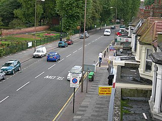
Well Hall is a place to the north of Eltham in the Royal Borough of Greenwich in southeast London, England, with no present formal boundaries and located 13.5 km (8.4 mi) east-southeast of Charing Cross. In the past Well Hall was the grounds of a manor house, and then a hamlet. Today it is a largely residential suburb and housing estate absorbed by the development of Eltham and London. It is centred on the main road between Eltham and Woolwich, on which many shops and businesses are located. Several major A roads including the South Circular Road and A2 road pass through the area, as does a railway line, serving Eltham station which is located in Well Hall. The Postcode that covers Well Hall and most of the Eltham area is SE9, and the 020 dialing covers the entire Royal Borough of Greenwich. Well Hall is split across two electoral wards, Eltham West on the west side of Well Hall Road, and Eltham North on the east side of Well Hall Road. In 2015 the population of these two wards combined was recorded as 24,621, although the wards cover a larger area than just Well Hall.

Northolt Manor is a 1.8 hectare scheduled monument, local nature reserve and Site of Borough Importance for Nature Conservation, Grade II, in Northolt in the London Borough of Ealing. It is owned and managed by Ealing Council.

Kidbrooke Village is a residential development located in the Kidbrooke area of the Royal Borough of Greenwich, in London, England. It is part of a larger regeneration project aimed at transforming the former Ferrier Estate into a new, mixed-use community. The development is a collaborative effort involving the local government, housing developers, and community stakeholders.
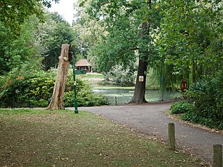
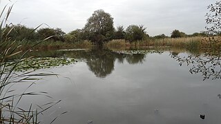
The Tarn is a 9 acres (3.6 ha) site on Court Road between Mottingham and Eltham, in the Royal Borough of Greenwich, southeast London, United Kingdom, consisting of a public garden, a bird sanctuary nature reserve and a lake amongst woodland. The woodland and lake, which was historically known as Starbuck's Pond, were previously the southern part of the Great Park, one of three parks belonging to the estate of Eltham Palace and used as a royal deer hunting park for several centuries up until the English Civil War. As a garden The Tarn opened in 1935, after the Metropolitan Borough of Woolwich acquired the site from the adjacent Royal Blackheath Golf Course. The Tarn remains largely unchanged since the 1930s and contains several shelters, benches, a public toilets building and a circular path which crosses a wooden footbridge spanning the lake. There is also an 18th-century ice house in the garden, which is a listed structure.


