Wandle Meadow Nature Park

Last updated
Wandle Meadow Nature Park 3.JPG

Wandle Meadow Nature Park is a 4.15 hectare local nature reserve and Site of Borough Importance for Nature Conservation, Grade 1, in Wimbledon in the London Borough of Merton. [1] [2] It is owned and managed by Merton Council. [3]

Local nature reserve (LNR) is a designation for nature reserves in Great Britain. The designation has its origin in the recommendations of the Wild Life Conservation Special Committee which established the framework for nature conservation in the United Kingdom and suggested a national suite of protected areas comprising national nature reserves, conservation areas, national parks, geological monuments, local nature reserves and local educational nature reserves.

Site of Nature Conservation Interest (SNCI), Site of Importance for Nature Conservation (SINC) and regionally important geological site (RIGS) are designations used by local authorities in the United Kingdom for sites of substantive local nature conservation and geological value. The Department for Environment, Food and Rural Affairs has recommended the generic term 'Local Site', which is divided into 'Local Wildlife Site' and 'Local Geological Site'.

Wimbledon, London Suburb of London

Wimbledon is a district and town of south-west London, England, 7.1 miles (11.4 km) south-west of the centre of London at Charing Cross, in the London Borough of Merton, south of Wandsworth, north-east of New Malden, north-west of Mitcham, west of Streatham and north of Sutton. Wimbledon had a population of 68,187 in 2011 which includes the electoral wards of Abbey, Dundonald, Hillside, Trinity, Village, Raynes Park and Wimbledon Park.

Contents

A map of 1847 shows the site as Byegrove Mead, which may have been managed as water meadows. In 1877 it was acquired by a sewage company, and it formed part of a sewage works until this closed in 1970. A plan to build a stadium for Wimbledon Football Club on the site was strongly opposed by local residents, and in 1989 it was designated as a nature reserve by Merton Council. [1]

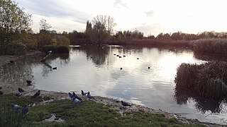
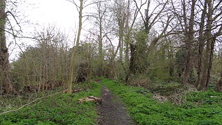
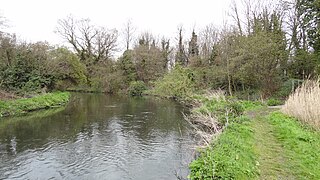
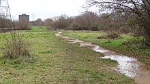
The Meadow lies between the River Wandle and Mead Path, part of the Wandle Trail. Wetland plants and animals include small sweet-grass, eared willow and broad-bodied chaser dragonflies. Bullfinches, whitethroats and reed buntings breed in woodland areas. [4] There are also bodies of water which have a variety of frogs, toads and newts. [5]

River Wandle river in South-East England

The River Wandle is the largest river of the south southwest sector of London, England. Its name is thought to derive from the community around its mouth, Wandsworth. About 9 miles (14 km) long, it passes through the London Boroughs of Croydon, Sutton, Merton, and Wandsworth to join the River Thames on the Tideway. Much of the river is accessible on the Wandle Trail. A short headwater - the Caterham Bourne - is in Surrey, the historic county of the river's catchment.

Wandle Trail

The Wandle Trail is a 12.5-mile (20 km) walking and cycling trail that follows the River Wandle from Croydon to Wandsworth in south-west London

The Nature Reserve is accessible via Chaucer Way, Boundary Road & North Road in Colliers Wood, a footbridge across the River Wandle from Garfield Road Recreation Ground in South Wimbledon and from a footpath at Plough Lane, Wimbledon. [1]

See also

Related Research Articles

Beverley Brook watercourse in United Kingdom

Beverley Brook is a minor English river 14.3 km (8.9 mi) long in southwest London. It rises in Worcester Park and joins the River Thames to the north of Putney Embankment at Barn Elms.

Walking in London popular recreational activity in London

Walking is a popular recreational activity in London, despite traffic congestion. There are many areas that provide space for interesting walks, including commons, parks, canals, and disused railway tracks. This includes Wimbledon Common, Epping Forest, Hampstead Heath, and the eight Royal Parks: Hyde Park, Regents Park, Richmond Park, etc. In recent years access to canals and rivers, including the Regent's Canal, and the River Thames has been greatly improved, and as well a number of long distance walking routes have been created that link green spaces.

Parks and open spaces in the London Borough of Croydon

The London Borough of Croydon has over 120 parks and open spaces within its boundaries, ranging from the 200 acre (80ha) Selsdon Wood Nature Reserve to many recreation grounds and sports fields scattered throughout the Borough. Croydon covers an area of 86.52 km², the 256th largest district in England. Croydon's physical features consist of many hills and rivers that are spread out across the borough and into the North Downs, Surrey and the rest of South London. Some of the open spaces in Croydon form part of the well-known London LOOP walks where the first section was opened on 3 May 1996 with a ceremony on Farthing Downs in Coulsdon. As a borough in Outer London it also contains some open countryside in the form of country parks. Croydon Council is associated with several other boroughs who are taking part in the Downlands Countryside Management Project. These boroughs are Sutton; and by Surrey County Council; the City of London Corporation; the Surrey districts of Reigate and Banstead and Tandridge; and the Countryside Agency. An additional partner is Natural Britain.

Rye Meads

Rye Meads is a 58.5 hectare biological Site of Special Scientific Interest (SSSI) in Rye House, Hertfordshire. It is one of series of wetlands and reservoirs situated along the River Lea, to the north-east of London. It is part of the Lea Valley RAMSAR site and a Special Protection Area.

Sutcliffe Park public park in Eltham in the Royal Borough of Greenwich in London

Sutcliffe Park is a 16.7 hectare public park in Eltham in the Royal Borough of Greenwich in London. A large part of the park is a local nature reserve and a Site of Borough Importance for Nature Conservation, Grade II. Fauna include dragonflies, damselflies, kingfishers, snipe and reed warblers. The River Quaggy runs through the park, and it has an athletics track and outdoor gym. It received a Green Flag award for 2012-13.

Fishpond Wood and Beverley Meads

Fishpond Wood and Beverley Meads is a 5.8 hectare local nature reserve adjacent to Wimbledon Common in the London Borough of Merton. It is owned by Merton Council and managed by the London Wildlife Trust.

Morden Park (park)

Morden Park is a 50 hectare public park and Site of Borough Importance for Nature Conservation, Grade 1, in the district of Morden Park in the London Borough of Merton. An area of 28 hectares is also a Local Nature Reserve. It is owned and managed by Merton Council. The site includes the Morden Park mound, a Scheduled Ancient Monument, and Pyl Brook runs through the park.

Ravensbury Park

Ravensbury Park is a public park in Mitcham in the London Borough of Merton. An area of 7 hectares is designated a Local Nature Reserve. The River Wandle runs along the southern boundary of the park, which is also part of the Upper Wandle River Site of Metropolitan Importance for Nature Conservation.

Bennetts Hole Local Nature Reserve in Mitcham, London

Bennett's Hole is a 1.2 hectare Local Nature Reserve in Mitcham in the London Borough of Merton. According to the Natural England details page about the site, it is owned by Merton Council and managed by the council and London Wildlife Trust, but it is not shown on the Trust's list of reserves.

Wandle Valley Wetland

Wandle Valley Wetland is a 0.6 hectare Local Nature Reserve in Carshalton in the London Borough of Sutton. It is owned by the Council and managed by the Council together with Sutton Nature Conservation Volunteers.

Wilderness Island

Wilderness Island is the 2.7 hectare island between the Wandle and the Wrythe in Carshalton in the London Borough of Sutton. It is designated a Local Nature Reserve and a Site of Metropolitan Importance for Nature Conservation, is owned by Sutton Council and is managed by the London Wildlife Trust.

Sutton Ecology Centre Grounds

Sutton Ecology Centre Grounds is a 1.3 hectare Local Nature Reserve and Site of Borough Importance for Nature Conservation, Grade 1, in Carshalton in the London Borough of Sutton. It is owned by Sutton Council and managed by the Council together with the Friends of Sutton Ecology Centre.

Cherry Wood

Cherry Wood is a 1.8 hectare Local Nature Reserve and Site of Borough Importance for Nature Conservation, Grade II, in Morden Park in the London Borough of Merton. It is owned by Merton Council and managed by the council together with the Friends of Cherry Wood.

Derwent Floodwash

Derwent Floodwash is a 1.8 hectare Local Nature Reserve and Site of Borough Importance for Nature Conservation, Grade II, in Morden Park in the London Borough of Merton. It is owned by the London Borough of Wandsworth and managed by Merton Council. The site borders Pyl Brook, and it is designed to store flood waters when the brook overflows, preventing flooding of properties downstream.

Merton Park Green Walks

Merton Park Green Walks is a linear walk along the line of a former railway line between Merton Park tram stop and Morden Road in Merton Park in the London Borough of Merton. It is a 1.5 hectare Local Nature Reserve and a Site of Borough Importance for Nature Conservation, Grade II, which is owned and managed by Merton Council.

Sir Joseph Hood Memorial Wood

Sir Joseph Hood Memorial Wood is a 1.7 hectare Local Nature Reserve and a Site of Borough Importance for Nature Conservation, Grade I, in Motspur Park in the London Borough of Merton. It adjoins Sir Joseph Hood Memorial Playing Fields, and both are owned and managed by Merton Council.

Wandle Park, Merton

Wandle Park is a public park in the London Borough of Merton near Colliers Wood Underground station in south London, England.

References

  1. 1 2 3 "Wandle Meadow Nature Park". London Parks and Gardens Trust. Retrieved 20 December 2013.
  2. "Map of Wandle Meadow Nature Park". Local Nature Reserves. Natural England. Retrieved 20 December 2013.
  3. "Wandle Meadow Nature Park". Local Nature Reserves. Natural England. 8 March 2013. Retrieved 20 December 2013.
  4. "Wandle Trail Nature Park and Lower River Wandle". Greenspace Information for Greater London. 2013. Retrieved 20 December 2013.
  5. "Nature reserves". Merton Council. Retrieved 20 December 2013.

Coordinates: 51°25′26″N0°10′59″W / 51.424°N 0.183°W / 51.424; -0.183

Geographic coordinate system Coordinate system

A geographic coordinate system is a coordinate system that enables every location on Earth to be specified by a set of numbers, letters or symbols. The coordinates are often chosen such that one of the numbers represents a vertical position and two or three of the numbers represent a horizontal position; alternatively, a geographic position may be expressed in a combined three-dimensional Cartesian vector. A common choice of coordinates is latitude, longitude and elevation. To specify a location on a plane requires a map projection.