
Deoria district, one of the districts of eastern Uttar Pradesh, India has its headquarters located at Deoria and is a part of Gorakhpur division. It came into existence on 16 March 1946 from Gorakhpur district.

Jalaun district is a district of Uttar Pradesh, India. The district is named after the town of Jalaun, which was the former headquarters of a Maratha governor, but the administrative headquarters of the district is at Orai.

Siwan is a city and nagar parishad in the Indian state of Bihar. It is the administrative headquarters of Siwan district and one of the urban settlements out of three in the district. It is located close to Uttar Pradesh.

Sant Kabir Nagar district is one of the 75 districts of Uttar Pradesh state in northern India. Khalilabad is the district headquarters. Sant Kabir Nagar district is a part of Basti division. The total area of Sant Kabir Nagar district is 1,646 km2 (636 sq mi).

Hamirpur district is one of the 75 districts of Uttar Pradesh state of India and Hamirpur town is the district headquarters. Hamirpur district is a part of Chitrakoot Division. The district occupies an area of 4,121.9 km2. The district has a population of 1,104,285. As of 2011 it is the third least populous district of Uttar Pradesh, after Mahoba and Chitrakoot. Two major rivers Yamuna and Betwa meet here. On the banks of river Betwa lies the "Coarse sand" which is exported to many parts in U.P.

Shravasti district is one of the districts of the Uttar Pradesh state of India, with Bhinga town as its district headquarters. Shravasti district is a part of Devipatan Division. According to Government of India, it is among the 121 minority concentrated districts in India. It is the fourth most backward district in India, according to the 2018 Niti Aayog ranking. This district is the most poverty stricken district in the country.
Maharajganj district is one of the 75 districts of Uttar Pradesh state in northern India, and the town of Maharajganj is the district headquarters. District is a part Gorakhpur division. It is located in Terai region of Himalayas, bordering Nepal in North. Gandak, Rapti, Rohin are some major river flowing through the district.
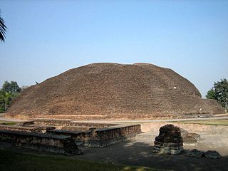
Kushinagar is a district of the state of Uttar Pradesh in India situated in the easternmost part of the state. It has the administrative headquarters at Ravindra Nagar Dhoos. The district is named such after the town Kushinagar, a Buddhist pilgrimage site where Gautama Buddha attained parinirvana in the 5th century BCE. Since the independence of India, Kushinagar district was a part of Deoria District and came into existence on 13 May 1994 as a separate district division. It was earlier known as Padrauna and thereafter was renamed Kushinagar on 19 June 1997.

Gopalganj is a town, municipality and headquarters of Gopalganj district in the Indian state of Bihar.
Bhatpar Rani is a town and tehsil in Deoria District in the state of Uttar Pradesh in India. It belongs to Gorakhpur Division. It is located 48 km towards East from District headquarters Deoria.The Member of Legislative Council of Bhatpar Rani Constituency is Shri. Sabhakunwar Kushwaha In Bhatpar Rani, the block number of village is 127. The biggest village in this tehsil is Sarayan. Khan Sir(Teacher), Shilpi Raj(Singer) were born here.
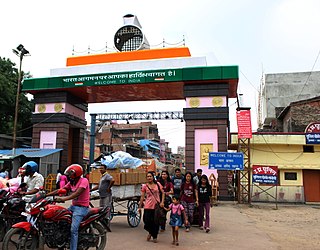
Deoria is a city in the state of Uttar Pradesh, India. It is one of five tehsils of the Deoria district. Deoria is located 45 km east of Gorakhpur and about 317 km from the state capital Lucknow. It shares its eastern border with the Indian state of Bihar.

Chitrakoot district is one of the districts of Uttar Pradesh state of India in the Bundelkhand region and Chitrakoot city is the district headquarters. Chitrakoot district is a part of Chitrakoot Division. The district occupies an area of 3,216 km2.The district has a population of 991,730. As of 2011 it is the second least populated district of Uttar Pradesh, after Mahoba.
Hata is a town located at NH-28 having 25 wards and a Nagarpalika in Kushinagar district in the Indian state of Uttar Pradesh. It is situated 36 km away from Gorakhpur in east. It is a major town of Kushinagar district situated on NH -28. Nearest railway station is Gauri Bajar, which is 17 km away from the town and the next major market of Kaptanganj is located 23 km away from it. Hata is the main market for wholesaler, local vendors & retailers.
Basti is a city, municipal board and administrative headquarters of Basti district in the Indian state of Uttar Pradesh. The district is part of Basti division. It is situated 202 kilometres east of the state capital, Lucknow.
Patherwa is a village in Kushinagar district, previously Deoria district, Uttar Pradesh, India. Situated along National Highway 28, it lies approximately 4 kilometers from Fazilnagar. Historically part of the Deoria district, Patherwa was incorporated into the newly formed Kushinagar district in 1994. The village is approximately 80 kilometers from the city of Gorakhpur and 25 kilometers east of the internationally renowned Buddhist pilgrimage site of Kushinagar, where Lord Buddha is believed to have attained Mahaparinirvana.
Piparahi is one of the habitations/localities of Amwa Khas village in the Kushinagar district of Uttar Pradesh. It comes under the Dudahi block of Tamkuhi Raj tehsil in the district. The locality is located about 5 kilometers away from the Gandaki River to the east. It is also about 3 kilometers near Uttar Pradesh-Bihar border to the north. The village is additionally 10 kilometers away from the broad-gauge Dudahi Railway Station, 35 kilometers away from the Tamkuhi Raj Assembly constituency on the Grand Trunk Road, and 38 kilometers from the district secretariat of Padrauna. Piparahi has one government primary school and one private primary school, that being Shri Mahatma Gandhi Gyan Mandir. This locality has two temples and a market, Piparahi Bazar.
Ait is a small town located in Jalaun district of Uttar Pradesh.
Baghirua is a large village located in Jagir block and Bhogaon Tehsil of Mainpuri district, Uttar Pradesh. As of 2011, it has a population of 2,748, in 437 households. It falls under Mainpuri Lok Sabha and Kishni Vidhan Sabha constituency.
Tamkuhi Raj is a constituency of the Uttar Pradesh Legislative Assembly covering the city of Tamkuhi Raj in the Kushinagar district of Uttar Pradesh, India.

Birnawan is a village in Sareni block of Rae Bareli district, Uttar Pradesh, India. It is located 19 km from Lalganj, the tehsil headquarters. As of 2011, it has a population of 485 people, in 92 households. It has two primary schools and no healthcare facilities. It belongs to the nyaya panchayat of Rasulpur.
