Kushinagar district

Last updated

Kushinagar district
Kushinagar district
Buddha's cremation stupa, Kushinagar.jpg
Buddha cremation stupa, Kushinagar
India Uttar Pradesh districts 2012 Kushinagar.svg
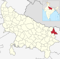
Location of Kushinagar district in Uttar Pradesh
CountryFlag of India.svg  India
State Uttar Pradesh
Division Gorakhpur
Established as Padrauna 13 May 1994
Name Changed from Padrauna to Kushinagar 19 June 1997
Headquarters Padrauna
Tehsils Padrauna Sadar, Khadda, Kushinagar/Kasia, Hata, Tamkuhiraj, Captanganj
Government
  Member of Parliament (Kushinagar) Vijay Kumar Dubey
   Lok Sabha constituencies Kushinagar
   Vidhan Sabha constituencies Padrauna Sadar, Khadda, Ramkola, Hata, Fazilnagar, Tamkuhiraj, Kushinagar
Area
  Total2,873.5 km2 (1,109.5 sq mi)
Population
 (2011)
  Total3,564,544
  Density1,200/km2 (3,200/sq mi)
   Urban
4.87%
Language

Official=Hindi,Urdu

Regional=Bhojpuri

Demographics
   Literacy 67.66 per cent
  Sex ratio955
Time zone UTC+05:30 (IST)
Vehicle registration UP 57
Major highways NH 27 and NH 727 (previously NH 28 and NH 28B)
Website kushinagar.nic.in

Kushinagar is a district of the state of Uttar Pradesh in India situated in the easternmost part of the state. It has the administrative headquarters at Ravindra Nagar Dhoos. The district is named such after the town Kushinagar, a Buddhist pilgrimage site where Gautama Buddha attained parinirvana in the 5th century BCE. Since the independence of India, Kushinagar district was a part of Deoria District and came into existence on 13 May 1994 as a separate district division. It was earlier known as Padrauna and thereafter was renamed Kushinagar on 19 June 1997.

Contents

Location

Kushinagar District is bounded on the northeast by West Champaran and Gopalganj districts of Bihar, on the south by Deoria District and on the west by Gorakhpur and Maharajganj districts. It is part of Gorakhpur Division.

Economy

In 2006 the Ministry of Panchayati Raj named Kushinagar one of the country's 250 most backward districts (out of a total of 640). [1] It is one of the 34 districts in Uttar Pradesh currently receiving funds from the Backward Regions Grant Fund Programme (BRGF). [1]

Transport

The Indian Government has approved a project for the construction of an International Airport which would be completed till 2019.[ citation needed ] In 2017, Uttar Pradesh Government has approved a project for develop Kushinagar bus station as an International Bus Station.[ citation needed ] Daily Buses from Gorakhpur to Tamkuhi Road and Gorakhpur to Padrauna through Kasia are available at Railway Station Bus Depot Gorakhpur.[ citation needed ]

Padrauna, Ramkola, Kaptanganj, Dudahi and Tamkuhi Road are some cities connected with train facility in the district.

On 20 October 2021 the international airport was officially inaugurated during the Abhidhamma Day celebrations in Kushinagar.

Demographics

Historical population
YearPop.±% p.a.
1901738,315    
1911804,023+0.86%
1921820,780+0.21%
1931876,462+0.66%
1941977,561+1.10%
19511,043,419+0.65%
19611,184,272+1.27%
19711,401,482+1.70%
19811,746,618+2.23%
19912,255,120+2.59%
20012,891,667+2.52%
20113,564,544+2.11%
source: [2]
Religions in Kushinagar district (2011) [3]
ReligionPercent
Hinduism
82.16%
Islam
17.40%
Other or not stated
0.44%

According to the 2011 census Kushinagar district has a population of 3,564,544, [4] roughly equal to the nation of Lithuania [5] or the US state of Connecticut. [6] This gives it a ranking of 81st in India (out of a total of 640). [4] The district has a population density of 1,226 inhabitants per square kilometre (3,180/sq mi). [4] Its population growth rate over the decade 2001-2011 was 23.08%. [4] Kushinagar has a sex ratio of 955 females for every 1000 males, [4] and a literacy rate of 67.66%. 4.72% of the population lives in urban areas. Scheduled Castes and Scheduled Tribes make up 15.27% and 2.25% of the population respectively. [4]

Languages in Kushinagar district (2011) [7]

   Bhojpuri (77.67%)
   Hindi (21.79%)
  Others (0.54%)

According to 2011 Census, 77.67% of the population in the district spoke Bhojpuri and 21.79% Hindi as their first language. [7]

Bhojpuri is the local language of Kushinagar. The Bhojpuri variant of Kaithi is the indigenous script of Bhojpuri language. [8]

Related Research Articles

<span class="mw-page-title-main">Garhwa district</span> District of Jharkhand in India

Garhwa District is one of the twenty-four districts in the Indian state of Jharkhand. The Garhwa District is part of the Palamu division and has its administrative headquarters in Garhwa City.

<span class="mw-page-title-main">Basti district</span> District of Uttar Pradesh in India

Basti district is one of the districts of Uttar Pradesh state, India, and a part of Basti Division. Basti city is the district headquarters.

<span class="mw-page-title-main">Azamgarh district</span> District in Uttar Pradesh, India

Azamgarh district is one of the three districts of Azamgarh division in the Indian state of Uttar Pradesh.

<span class="mw-page-title-main">Chandauli district</span> District in Uttar Pradesh, India

Chandauli district is a district of Uttar Pradesh state of India, and Chandauli town is the district headquarters. Chandauli district is a part of Varanasi Division. Chandauli became a separate district on 20 May 1997.

<span class="mw-page-title-main">Deoria district</span> District of Uttar Pradesh in India

Deoria district, one of the districts of eastern Uttar Pradesh, India has its headquarters located at Deoria and is a part of Gorakhpur division. It came into existence on 16 March 1946 from Gorakhpur district.

<span class="mw-page-title-main">Jalaun district</span> District of Uttar Pradesh in India

Jalaun district is a district of Uttar Pradesh, India. The district is named after the town of Jalaun, which was the former headquarters of a Maratha governor, but the administrative headquarters of the district is at Orai.

<span class="mw-page-title-main">Kaushambi district</span> District of Uttar Pradesh in India

Kaushambi district is a district in the state of Uttar Pradesh in India. Manjhanpur is the district headquarters. The district was carved from Prayagraj district on 4 April 1997. Manauri Bajar connects Prayagraj and Kaushambi districts by railway over a bridge on SH-95. Manjhanpur is south-west of Prayagraj on the north bank of the Yamuna river, about 55 kilometres (34 mi) from the city. It is surrounded by Chitrakoot district on the south, Pratapgarh district on the north, Prayagraj district on the east and Fatehpur district on the west. Kaushambi is part of Prayagraj division. The nearest railway station, in Bharwari, connects with Delhi, Prayagraj, Kolkata, Gaya and Kanpur.

<span class="mw-page-title-main">Pratapgarh district, Uttar Pradesh</span> District of Uttar Pradesh in India

The Pratapgarh district is one of the districts of Uttar Pradesh state of India, and Pratapgarh city is the district headquarters. Pratapgarh district is a part of Prayagraj division. The total area of Pratapgarh district is 3730 Sq. km.

<span class="mw-page-title-main">Mau district</span> District in Uttar Pradesh, India

Mau district is one of the districts of Uttar Pradesh state of India, and Mau town is the district headquarters which is also one of the few remaining areas of handloom saree production in eastern Uttar Pradesh, specializing in Sadiya silk sarees. Mau was carved out as a separate district from Azamgarh on 19 November 1988. It is situated in the south-eastern part of the state with headquarters in Maunath Bhanjan. The district is surrounded by Ghazipur district on the south, Ballia district in the east, Azamgarh district in the west, and by Gorakhpur and Deoria districts on the north; says, Pallavi mishra.

<span class="mw-page-title-main">Sant Kabir Nagar district</span> District of Uttar Pradesh in India

Sant Kabir Nagar district is one of the 75 districts of Uttar Pradesh state in northern India. Khalilabad is the district headquarters. Sant Kabir Nagar district is a part of Basti division. The total area of Sant Kabir Nagar district is 1,646 km2 (636 sq mi).

<span class="mw-page-title-main">Hamirpur district, Uttar Pradesh</span> District of Uttar Pradesh in India

Hamirpur district is one of the 75 districts of Uttar Pradesh state of India and Hamirpur town is the district headquarters. Hamirpur district is a part of Chitrakoot Division. The district occupies an area of 4,121.9 km². The district has a population of 1,104,285. As of 2011 it is the third least populous district of Uttar Pradesh, after Mahoba and Chitrakoot. Two major rivers Yamuna and Betwa meet here. On the banks of river Betwa lies the "Coarse sand" which is exported to many parts in U.P.

<span class="mw-page-title-main">Mahoba district</span> District of Uttar Pradesh in India

Mahoba district is one of the districts of Uttar Pradesh state of India and Mahoba city is the district headquarters. Mahoba district is a part of Chitrakoot Division. The district occupies an area of 2884 km². It has a population of 875,958. As of 2011 it is the least populous district of Uttar Pradesh. Mahoba District is also known as Alha-Udal Nagari.

<span class="mw-page-title-main">Shravasti district</span> District of Uttar Pradesh in India

Shravasti district is one of the districts of the Uttar Pradesh state of India, with Bhinga town as its district headquarters. Shravasti district is a part of Devipatan Division. According to Government of India, it is among the 121 minority concentrated districts in India. It is the fourth most backward district in India, according to the 2018 Niti Aayog ranking. This district is the most poverty stricken district in the country.

<span class="mw-page-title-main">Ambedkar Nagar district</span> District of Uttar Pradesh, India

Ambedkar Nagar is a district in the Indian state of Uttar Pradesh. This district is a part of Ayodhya division in the Awadh region of the state. This district was established on 29 September 1995 by carving out parts of the erstwhile Faizabad district. It was created by the then Chief Minister Mayawati and named in memory of Bhimrao Ambedkar, who worked for the advancement of the depressed classes. The total area of Ambedkar Nagar district is 2350 Sq. Km.

<span class="mw-page-title-main">Maharajganj district</span> District of Uttar Pradesh in India

Maharajganj district is one of the 75 districts of Uttar Pradesh state in northern India, and the town of Maharajganj is the district headquarters. District is a part Gorakhpur division. It is located in Terai region of Himalayas, bordering Nepal in North. Gandak, Rapti, Rohin are some major river flowing through the district.

<span class="mw-page-title-main">Gonda district</span> District of Uttar Pradesh in India

Gonda district is one of the districts of Uttar Pradesh, India. The city of Gonda is the district headquarters, and also the administrative centre for the Devipatan Division. The total area of Gonda district is 4,003 km2 (1,546 sq mi).

<span class="mw-page-title-main">Mirzapur district</span> District in Uttar Pradesh, India

Mirzapur district is one of the 75 districts in the Indian state of Uttar Pradesh. The district is bounded on the north by Bhadohi and Varanasi districts, on the east by Chandauli district, on the south by Sonbhadra district and on the northwest by Prayagraj. The district occupies an area of 4521 km2. Mirzapur city is the district headquarters. Mirzapur district is a part of Mirzapur division. This district is known for the Vindhyavasini temple in Vindhyachal and several tourist attractions like water falls like Rajdari & Devdari and dams. It consist of several Ghats where historical sculptures are still present. During the Ganges festival these Ghats are decorated with lights and diyas.

<span class="mw-page-title-main">Gorakhpur district</span> District of Uttar Pradesh in India

Gorakhpur district is one of the 75 districts of Uttar Pradesh state in northern India. This district is a part of the Gorakhpur division. The city of Gorakhpur, or Gorakhpur is the administrative headquarters of this district and Gorakhpur division. It borders Sant Kabir Nagar district to the west, Kushinagar and Deoria districts to the east, and Maharajganj and Azamgarh districts to the north and south.

<span class="mw-page-title-main">Chitrakoot district</span> District of Uttar Pradesh in India

Chitrakoot district is one of the districts of Uttar Pradesh state of India in the Bundelkhand region and Chitrakoot city is the district headquarters. Chitrakoot district is a part of Chitrakoot Division. The district occupies an area of 3,216 km².The district has a population of 991,730. As of 2011 it is the second least populated district of Uttar Pradesh, after Mahoba.

<span class="mw-page-title-main">Siddharthnagar district</span> District of Uttar Pradesh in India

Siddharthnagar district is one of the 75 districts of the Indian state of Uttar Pradesh. Siddharthnagar is the district headquarters. Siddharthnagar district is a part of Basti division. It was under the ancient Kosala kingdom and also the Shakya kingdoms.

References

  1. 1 2 Ministry of Panchayati Raj (8 September 2009). "A Note on the Backward Regions Grant Fund Programme" (PDF). National Institute of Rural Development. Archived from the original (PDF) on 5 April 2012. Retrieved 27 September 2011.
  2. "Decadal Variation In Population Since 1901". www.censusindia.gov.in. Retrieved 6 February 2021.
  3. "Table C-01 Population by Religion: Uttar Pradesh". censusindia.gov.in. Registrar General and Census Commissioner of India. 2011.
  4. 1 2 3 4 5 6 "District Census Handbook: Kushinagar" (PDF). censusindia.gov.in. Registrar General and Census Commissioner of India. 2011.
  5. US Directorate of Intelligence. "Country Comparison:Population". Archived from the original on 13 June 2007. Retrieved 1 October 2011. Lithuania 3,535,547 July 2011 est.
  6. "2010 Resident Population Data". U. S. Census Bureau. Archived from the original on 19 October 2013. Retrieved 30 September 2011. Connecticut 3,574,097
  7. 1 2 "Table C-16 Population by Mother Tongue: Uttar Pradesh". www.censusindia.gov.in. Registrar General and Census Commissioner of India.
  8. Grierson, George Abraham (1881). A handbook to the Kayathi character. The Library of Congress. Calcutta, Thacker, Spink, and co.

26°54′09″N83°58′55″E / 26.90250°N 83.98194°E / 26.90250; 83.98194