Padrauna

Last updated

Padrauna
City
Main Gate of the Palace.jpg
Main gate of the palace
Nickname: 
PAVA
India Uttar Pradesh relief map.svg
Red pog.svg
Padrauna
Location in Uttar Pradesh, India
Coordinates: 26°54′N83°59′E / 26.9°N 83.98°E / 26.9; 83.98
CountryFlag of India.svg  India
State Uttar Pradesh
District Kushinagar
Government
  TypeDemocratic
  BodyMunicipal board
Population
 (2011)
  Total49,723
  Rank300+
Time zone UTC+5:30 (IST)
PIN
274304
Telephone code05564
Vehicle registration UP-57
Sex ratio 950 (approx.) /
Website www.kushinagar.nic.in

Padrauna is a city and headquarter of Kushinagar district in the Indian state of Uttar Pradesh. It is the place where Rama spent a few days of his life. After passing from Padrauna, Rama reached at Ramkola where he made a hut with his wife Sita and younger brother Lakshman to stay. It is situated 19 kilometres (12 mi) northeast of Kushinagar International Airport. Udit Narayan Intermediate College is the biggest College in the Kushinagar district .

Contents

Connectivity

The town is connected to many important cities through National Highway 28B [1] and State Highway No. 64. A daily bus travels the route from Padrauna to Kanpur, while another bus route connects Padrauna with Lucknow. Padrauna Railway Station connects Padrauna to Chhapra, Gorakhpur, Lucknow, Siddharthnagar, Delhi, Katihar, Jalandar, and other important cities. Padrauna is also close to Kushinagar International Airport. The proposed Buddha Expressway between Kushinagar and Sarnath will provide connectivity with southeastern cities in the state like Varanasi, Allahabad, Azamgarh as well as Kolkata through National Highway 2 in Varanasi.

Economy

The economy of Padrauna mainly consists of Agriculture followed by Services and a little contribution is made by Industrial sector. There are many family run businesses, shops, vendors, hawkers, etc., in tamkhurod. A number of small and mid-size hotels exist in Padrauna. Earlier there were few industries (Kanpur Sugar Works, sugar factory for example) which are no more operational. The shutting down of factories led to poverty and backwardness of this region. The backwardness is further soared by the power shortage in this region.

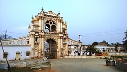
Landmarks and geography

Disused sugar factory Sugar Factory in dilapidated state.jpg
Disused sugar factory

Notable landmarks are: Subhash Chowk, Tilak Chowk, Ambay Chowk, Chawani, Ravindra Nagar, Nahar, Rajdarbar, Gudaribajar, Lajpat Nagar, Durgamandir, Jataharoad, Belawan chungi, Bawali Chowk Sugar Factory etc. Though Padrauna is a district headquarter yet almost all the offices like Kutchery, Vikas Bhavan, Income Tax Office, Collectorate, District Hospital etc. are situated in Ravindra Nagar Dhoos. It lies in the Great Plains and is Terai area, very close to piedmont plains of Himalayas, and is very close to borders of Nepal and Bihar. It is located on the bank of river Bansi, a Ganges tributary originating in Nepal. The town presents characteristics distinct from natural features of the western districts of Uttar Pradesh. This difference is due primarily to the relative proximity of the Himalayas, the outermost foothills of which are only a few kilometres from the northern borders. The peak of Dhaulagiri, some 8,230 meters above sea-level, is visible under favourable climatic conditions as far south as Padrauna itself. Below the outer hills is a dry boulder-strewn tract, corresponding to the Bhabar of Kumaun and Garhwal and here the bulk of the moisture contributed by the rainfall and the small streams is absorbed by the soil, to reappear through seepage in the damp and unhealthy tract, known as the terai. The climate is extreme temperate climate, with soaring temperatures in summer crossing 40 degrees and in winters temperatures as low as 3 to 4 degrees.

Education

Udit Narayan Inter College UditNarayanInterCollege.jpg
Udit Narayan Inter College

The town has several schools like Vivekanand Inter College, Kendriya Vidyalaya Navodaya Vidyalaya, Goswami Tulsi Das Intermediate college, VBD INTERNATIONAL PUBLIC SCHOOL, Tulsi vidya niketan, Udit Narayan Intermediate College, JDS International School, (Affiliate to CBSE) Kiddy's Corner School, D.D.N. Public School, Midas School of Learning, Geeta International Public School, Udit Narayan Post Graduate College, Bhartiya Intermediate College, St. Therese's School (affiliated to ICSE), Summer Field Public School, Hanuman Intermediate College, Real Paradise Academy School, ITI, Tapesawari Vidya Mandir, HIIT institute, Shree Ganga Public School, St. Xavier's Senior Secondary School (affiliated to CBSE), Seth M R Jaipuria School, Post Graduate Colleges affiliated to DDU Gorakhpur

Literacy rate is relatively low as compared to the UP state average 69.72 and 63% of its residents are literate. [2] After pursuing 10th and 12th standard from Padrauna, students travel to other cities like Lucknow, Allahabad, Varanasi and sometimes up to New Delhi as well. Students from here are primarily interested in government sector jobs and secondary preference is private jobs.[ citation needed ]

Two men enjoying an elephant ride in Market Street Elephantridepadrauna.jpg
Two men enjoying an elephant ride in Market Street

Radio stations

Radio Pragya 90.4 MHz is a community radio station in Padrauna, Kushinagar district.

Demographics

The majority is Hinduism while other religions with dominant position are Islam, Sikhism and small population of Buddhism and Christianity exists in Padrauna. Padrauna is also known for garh of Saithwar Kurmi. RPN Singh belong to this community.

Related Research Articles

<span class="mw-page-title-main">Faizabad</span> City in Uttar Pradesh, India

Faizabad is a city located in Ayodhya district in the Indian state of Uttar Pradesh. It is situated on the southern bank of the River Saryu about 6.5 km from Ayodhya City, the district headquarter, 130 km east of the state capital Lucknow. Faizabad was the first capital of the Nawabs of Awadh and has monuments built by those Nawabs, like the Tomb of Bahu Begum, Gulab Bari. It was also the headquarters of Faizabad district and Faizabad division before November 2018. Faizabad is a twin city of Ayodhya and it is administered by Ayodhya Municipal Corporation.

<span class="mw-page-title-main">Unnao</span> City in Uttar Pradesh, India

Unnao is a city in the Indian state of Uttar Pradesh. It is the administrative headquarters of Unnao district and a part of Lucknow division, between Kanpur and Lucknow. Unnao is a large industrial city with three industrial suburbs around it. Unnao has the country's largest leather Export in the UPSIDC.

<span class="mw-page-title-main">North Eastern Railway zone</span> Zones of Indian Railways

The North Eastern Railway is one of the 18 railway zones of Indian Railways. It is headquartered at Gorakhpur.

Ballia is a city with a municipal board in the Indian state of Uttar Pradesh. The eastern boundary of the city lies at the junction of two major rivers, the Ganges and the Ghaghara.The city is situated 140 km (87 mi) east of Varanasi and about 380 km from the state capital Lucknow. It is home to a protected area, the Jai Prakash Narayan bird sanctuary. Ballia is around 4 km (2.5 mi) from Bihar.

<span class="mw-page-title-main">Kulpahar</span> City in Uttar Pradesh, India

Kulpahar is a city in Mahoba district in the Indian state of Uttar Pradesh. It is a historical town in the Bundelkhand region. Before 11 Feb 1995 Kulpahar was a Tehsil of Hamirpur District. On 11 Feb 1995 Mahoba District was carved out of Hamirpur, and Kulpahar is now a part of the Mahoba District. Kulpahar is the largest Subdivision of Uttar Pradesh. Kulpahar is known for its closeness to Khajuraho and other historic places like Mahoba, Charkhari, Kalinjar Rath, Orchha, and Jhansi. This town holds relics of temples and man-made water bodies of the Chandela Dynasty

Bilariaganj is the second largest city and a Nagar Palika Parishad in Azamgarh division after its capital city Azamgarh in the state of Uttar Pradesh, India.

Pharenda, or Anandnagar, is a city in the Maharajganj district of the province of Uttar Pradesh in northern India. It is located approximately 44 kilometres north of Gorakhpur near the border with Nepal. District of Pharenda is Maharajganj. This is situated on the Buddhist Circuit which is built from Sarnath to Lumbini. It lies on NH-24 and near NH 29. It is about 45 km from Gorakhpur, 40 km from Siddharthnagar, 30 km from Maharajganj and 55 km from Sonauli Indo-Nepal border. This place is named after Seth Anandram Jaypuriya. There is closed sugar Mill which was started in about 1935 and closed in 1995. Near Anand Nagar there is a temple is Durga devi mandir, popularly known as Lehara Devi mandir.

Kaptanganj is a town, a Tehsil and a Nagar Panchayat in Kushinagar district of Uttar Pradesh, a state in the Republic of India.

Rajapur is a town and tehsil of Chitrakoot district in the Indian state of Uttar Pradesh. It is situated along the bank of river Yamuna. It has its nickname as "Tulsi Dhaam" after great Hindi poet Goswami Tulsidas, who is the writer of holy "Ram Charit Manas" along with many other religious books of Hindus. There is a temple devoted to Tulsidas where part of the original "Hand written Scripture" of Ramcharitmanas is still available, although some pages may be missing. Rajapur is linked with Kaushambi district on the opposite bank of river Yamuna.

<span class="mw-page-title-main">Renukoot</span> Village in Uttar Pradesh, India

Renukoot is a town and a nagar panchayat in Sonbhadra district in the Indian state of Uttar Pradesh. It is 68 km south from the district headquarters Robertsganj.

<span class="mw-page-title-main">Akbarpur, Ambedkar Nagar</span> City in Uttar Pradesh, India

Akbarpur is a city, municipal corporation, tehsil, and the administrative headquarters of Ambedkar Nagar district in the state of Uttar Pradesh, India. It is a part of Ayodhya division.

<span class="mw-page-title-main">Tourism in Uttar Pradesh</span> Overview of tourism in the Indian state of Uttar Pradesh

Situated in the northern part of India, bordering with the capital of India New Delhi, Uttar Pradesh is one of the most popular and an established tourist destination for both Indians and non-Indians alike in India. The most populous state of India, Uttar Pradesh contains many historical monuments and places of religious significance. Geographically, Uttar Pradesh is very diverse, with Himalayan foothills in the extreme north and the Gangetic Plain in the centre. It is also home of India's most visited sites, Hinduism's holiest city, Varanasi. Kumbh city, Prayagraj. Kathak, one of the eight forms of Indian classical dances, originated from Uttar Pradesh. Uttar Pradesh is at the heart of India, hence it is also known as The Heartland of India. Cuisine of Uttar Pradesh like Awadhi cuisine, Mughlai cuisine and Bhojpuri cuisine are very famous not only in India but also many places abroad.

The state of Uttar Pradesh had a small tradition of learning, although it had remained mostly confined to the elite class and the religious establishment.

<span class="mw-page-title-main">Christianity in Uttar Pradesh</span> Overview of Christianity in the Indian state of Uttar Pradesh

Christianity is a minority religion in Uttar Pradesh, the largest state of India. The Christians of Uttar Pradesh come under the territory of Lucknow and Agra Diocese of Church of North India and of the Archdiocese of Agra. The Uttar Pradesh Christian Revival Church (UPCRC) was established in 2017 as a part of the Christian Revival Church.

<span class="mw-page-title-main">Uttar Pradesh Expressways Industrial Development Authority</span> Indian agency controlled by Government of Uttar Pradesh

The Uttar Pradesh Expressways Industrial Development Authority (UPEIDA) is an authority set up in 2007 by the Government of Uttar Pradesh to develop expressway projects in the state. The headquarters of UPEIDA is located at Paryatan Bhawan in Gomti Nagar, Lucknow.

<span class="mw-page-title-main">Udit Narayan Post Graduate College</span>

Udit Narayan Post Graduate College is a college at Padrauna town in Kushinagar district of Uttar Pradesh. College was established in 1962 and is managed by the trust named Udit Narayan Kshetriya School Society. Academically, it is affiliated with Deen Dayal Upadhyay Gorakhpur University and offers various Undergraduate and Post-graduate courses.

Manikpur Junction railway station is a railway station in Manikpur town of Chitrakoot district, Uttar Pradesh on Prayagraj–Jabalpur section. It is 99 km away from Prayagraj Junction. It has 4 platforms. Passenger and Superfast trains halt here.

References

  1. "NHAI::Welcome to NHAI". Archived from the original on 11 June 2016. Retrieved 6 October 2011.
  2. 2011 census results [ dead link ]