Ancient lake

Last updated
Lake Zaysan in Kazakhstan is one of the oldest lakes in the world. Zaysan.jpg
Lake Zaysan in Kazakhstan is one of the oldest lakes in the world.

An ancient lake is a lake that has consistently carried water for more than one million years. 12 of the 20 ancient lakes have existed for more than 2.6 million years, the full Quaternary period. Ancient lakes continue to persist due to plate tectonics in an active rift zone. This active rift zone creates lakes that are extremely deep and difficult to naturally fill with sediment. Due to the prolonged life of ancient lakes, they serve as models for isolated evolutionary traits and speciation. Most of the world's bodies of water are less than 18,000 years old. There are only 20 ancient lakes over 1 million years old. [1]

Contents

Lake Baikal is often considered the oldest, as clear evidence shows that it is 25–30 million years old. [2] [3] Lake Zaysan may be even older, of Cretaceous origin and at least 66 million years old [4] (most likely around 70 million years [5] ), but its exact age is controversial and labelled with some uncertainty. [6] Another contender for oldest is Lake Maracaibo, estimated to be 20–36 million years old. In ancient times it was indisputably a true lake, but today it is saline and directly connected to the sea, leading many to consider it a large lagoon or bay. [7]

Ancient lakes vs. younger lakes

There are six major types of lakes (listed below). The majority of lakes dry up as the result of the filling with lacustrine deposits, sediment deposited from a river into a lake over thousands of years. Factors that influence the water level decreasing include fluvial-lacustrine sediment build-up, evaporation, natural drainage and geophysical processes. Ancient Lakes have a prolonged life when compared to younger, more ordinary lakes due to the local active rift zones and subsided sections of land called grabens.

For example, Lake Baikal in Russia, the deepest lake in the world, is an ancient lake created by the Baikal Rift Zone which is 25–30 million years old and 5,387 feet (1,642 m) deep. This is compared to the North American Great Lakes, which were formed by the last glacial period by glacial scouring and the pooling of meltwater which are 14,000 years old and have maximum depths ranging from 200–1,300 feet (60–400 m) deep.

Formation of ancient lakes

Ancient lake formation is similar to that of a rift valley. Formation occurs within a graben that is located on an active rift zone. Grabens are sections of land, formed along divergent plate boundaries, which have subsided between two parallel plates. The location of the graben above the active rift zone results in a lake bottom that is constantly dropping in depth and walls increasing in height.

Importance to evolution

Ancient lakes allow scientists to study the mechanisms of environmental changes over glacial-interglacial timescales. Evolutionary characteristics including sexual selection, adaptive radiation and punctuated equilibrium are studied in ancient lakes due to their prolonged existence and general geographic isolation. Most of the research has been associated with the endemic fauna and diatoms that exist in these isolated lakes, concentrating on Lake Baikal, the Caspian Sea and the African Great Lakes. Information is derived from the associations of the fluvial-lacustrine, fluctuating profundal and evaporative facies.

List of ancient lakes

These are the 20 ancient lakes in the world that have existed for more than 1 million years. [1]

NameOriginTypeAgeArea
(km2)
Volume
(km³)
Depth maxDepth averageCountriesNotes
Lake Pingualuk meteor impactfresh, permanent, crater1.5 million8267 Canada
Lake Tahoe tectonicfresh, permanent1–2 million499156505313 United States
Lake Bosumtwi meteor impactsoda, permanent, crater1–2 million492.248145 Ghana
Lake Lanao volcanicfresh, permanent2 million37511260.3 Philippines
Lake Titicaca tectonicfresh, permanent3 million8372893281107 Bolivia, Peru
Lake Prespa tectonicfresh, permanent1.5-5 million2594.85418.7 Albania, Greece, North Macedonia
Lake Ohrid tectonicfresh, permanent1.5-5 million358.1853.63286.7163.71Albania North Macedonia
Lake Malawi tectonicfresh, permanent2–5 million296008400705292 Malawi, Mozambique, Tanzania
Lake Hovsgol tectonicfresh, permanent2–5 million2770381267138 Mongolia
Kati Thanda–Lake Eyre tectonicsaline, intermittent, endorheic2.5-5 million969030.163 Australia
Lake Tanganyika tectonicfresh, permanent3–6 million32000178001471572 Burundi, Congo, Tanzania, Zambia
Caspian Sea tectonicsaline, permanent, endorheic5.5 million374000782001025182 Azerbaijan, Iran, Kazakhstan, Russia, Turkmenistan
Aral Sea tectonicsaline, permanent5.5 million645006256716 Kazakhstan, Uzbekistan 
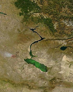
Formerly the fourth largest lake in the world with an area of 68,000 km2 (26,300 sq mi). By 1997, it had shrunk to 10% of its original size due to water that was diverted in the Soviet Era. It is now split into 4 smaller lakes. As of 2023, the Aral Sea has become mostly desert.
Lake Biwa tectonicfresh, permanent5–6 million67427.510441 Japan
Lake Tule tectonicfresh, permanent3–15 million5340 United States
Lake Maracaibo tectonicsaline, permanent, coastal bay20+ million130102806025.9 Venezuela Historically it was an ancient lake. Now a large tidal bay / inlet rather than a lake in the traditional sense. It is saline and directly connected to the Caribbean Sea, leading many to consider it a large lagoon or bay.
Lake Baikal tectonicfresh, permanent25+ million31500230001741740 Russia
Issyk-Kul tectonicsaline, permanent25 million62361738668270 Kyrgyzstan
Lake Vostok subglacialfresh, permanent, subglacial15–35 million125005400510432 Antarctica
Lake Zaysan tectonicfresh, permanent65+ million551053105 Kazakhstan The construction of the Bukhtarma dam inundated the lake, thus, in some sources the lake is considered a reservoir. [8]

Related Research Articles

<span class="mw-page-title-main">Lake Zaysan</span> Lake in Kazakhstan

Lake Zaysan or Zaisan, also known by other names in other languages, is a freshwater lake in Tarbagatay District, East Kazakhstan Region, Kazakhstan. It is the largest lake in the region. The lake is generally frozen from the beginning of November to the end of April, but still has an abundance of fish.

<span class="mw-page-title-main">Graben</span> Depressed block of planetary crust bordered by parallel normal faults

In geology, a graben is a depressed block of the crust of a planet or moon, bordered by parallel normal faults.

<span class="mw-page-title-main">Rift</span> Geological linear zone where the lithosphere is being pulled apart

In geology, a rift is a linear zone where the lithosphere is being pulled apart and is an example of extensional tectonics. Typical rift features are a central linear downfaulted depression, called a graben, or more commonly a half-graben with normal faulting and rift-flank uplifts mainly on one side. Where rifts remain above sea level they form a rift valley, which may be filled by water forming a rift lake. The axis of the rift area may contain volcanic rocks, and active volcanism is a part of many, but not all, active rift systems.

<span class="mw-page-title-main">Lake Ohrid</span> International lake in North Macedonia and Albania

Lake Ohrid is a lake which straddles the mountainous border between the southwestern part of North Macedonia and eastern Albania. It is one of Europe's deepest and oldest lakes, with a unique aquatic ecosystem of worldwide importance, with more than 200 endemic species.

<span class="mw-page-title-main">Depression (geology)</span> Landform sunken or depressed below the surrounding area

In geology, a depression is a landform sunken or depressed below the surrounding area. Depressions form by various mechanisms.

<span class="mw-page-title-main">Maracaibo Basin</span> Foreland basin in Venezuela

The Maracaibo Basin, also known as Lake Maracaibo natural region, Lake Maracaibo depression or Lake Maracaibo Lowlands, is a foreland basin and one of the eight natural regions of Venezuela, found in the northwestern corner of Venezuela in South America. Covering over 36,657 square km, it is a hydrocarbon-rich region that has produced over 30 billion bbl of oil with an estimated 44 billion bbl yet to be recovered. The basin is characterized by a large shallow tidal estuary, Lake Maracaibo, located near its center. The Maracaibo basin has a complex tectonic history that dates back to the Jurassic period with multiple evolution stages. Despite its complexity, these major tectonic stages are well preserved within its stratigraphy. This makes The Maracaibo basin one of the most valuable basins for reconstructing South America's early tectonic history.

The geology of the Netherlands describes the geological sequence of the Netherlands. Large parts of the Netherlands today are below sea level and have in the past been covered by the sea or flooded at regular intervals. The modern Netherlands formed as a result of the interplay of the four main rivers and the influence of the North Sea and glaciers during ice-ages. The Netherlands is mostly composed of deltaic, coastal and eolian derived sediments during the Pleistocene glacial and interglacial periods.

<span class="mw-page-title-main">Lacustrine plain</span> Lakes filled by sediment

A lacustrine plain or lake plain is a plain formed due to the past existence of a lake and its accompanying sediment accumulation. Lacustrine plains can be formed through one of three major mechanisms: glacial drainage, differential uplift, and inland lake creation and drainage. Lake plains can have various uses depending on where and how they form.

<span class="mw-page-title-main">Baikal Rift Zone</span> Part of the boundary between the Amur and Eurasian tectonic plates.

The Baikal Rift Zone is a series of continental rifts centered beneath Lake Baikal in southeastern Russia. Current strain in the rifts tends to be extending with some shear movement. A series of basins form along the zone for more than 2,000 kilometres (1,200 mi), creating a rift valley. The rifts form between the Eurasian Plate to the west and the Amur Plate to the east.

This is a list of articles related to plate tectonics and tectonic plates.

<span class="mw-page-title-main">Geology of the Pyrenees</span> European regional geology

The Pyrenees are a 430-kilometre-long, roughly east–west striking, intracontinental mountain chain that divide France, Spain, and Andorra. The belt has an extended, polycyclic geological evolution dating back to the Precambrian. The chain's present configuration is due to the collision between the microcontinent Iberia and the southwestern promontory of the European Plate. The two continents were approaching each other since the onset of the Upper Cretaceous (Albian/Cenomanian) about 100 million years ago and were consequently colliding during the Paleogene (Eocene/Oligocene) 55 to 25 million years ago. After its uplift, the chain experienced intense erosion and isostatic readjustments. A cross-section through the chain shows an asymmetric flower-like structure with steeper dips on the French side. The Pyrenees are not solely the result of compressional forces, but also show an important sinistral shearing.

<span class="mw-page-title-main">Geology of Russia</span> Overview of the geology of Russia

The geology of Russia, the world's largest country, which extends over much of northern Eurasia, consists of several stable cratons and sedimentary platforms bounded by orogenic (mountain) belts.

<span class="mw-page-title-main">Half-graben</span> Geological structure bounded by a fault along one side of its boundaries

A half-graben is a geological structure bounded by a fault along one side of its boundaries, unlike a full graben where a depressed block of land is bordered by parallel faults.

<span class="mw-page-title-main">Gulf of Mexico basin</span> Oceanic rift basin

The formation of the Gulf of Mexico, an oceanic rift basin located between North America and the Yucatan Block, was preceded by the breakup of the Supercontinent Pangaea in the Late-Triassic, weakening the lithosphere. Rifting between the North and South American plates continued in the Early-Jurassic, approximately 160 million years ago, and formation of the Gulf of Mexico, including subsidence due to crustal thinning, was complete by 140 Ma. Stratigraphy of the basin, which can be split into several regions, includes sediments deposited from the Jurassic through the Holocene, currently totaling a thickness between 15 and 20 kilometers.

<span class="mw-page-title-main">Taranaki Basin</span> Onshore-offshore Cretaceous rift basin on the West Coast of New Zealand

The Taranaki Basin is an onshore-offshore Cretaceous rift basin on the West Coast of New Zealand. Development of rifting was the result of extensional stresses during the breakup of Gondwanaland. The basin later underwent fore-arc and intra-arc basin development, due to the subduction of the Pacific Plate under the Australian Plate at the Hikurangi Subduction System. The basin covers approximately 100,000 km2 of which the majority is offshore. The basin contains mostly marine sediment, with significant terrestrial sediment from the Late Cretaceous to the Eocene. The majority of New Zealand's oil and gas production occurs within the basin, with over 400 wells and approximately 20 oil and gas fields being drilled.

<span class="mw-page-title-main">North German basin</span> Passive-active rift basin in central and west Europe

The North German Basin is a passive-active rift basin located in central and west Europe, lying within the southeasternmost portions of the North Sea and the southwestern Baltic Sea and across terrestrial portions of northern Germany, Netherlands, and Poland. The North German Basin is a sub-basin of the Southern Permian Basin, that accounts for a composite of intra-continental basins composed of Permian to Cenozoic sediments, which have accumulated to thicknesses around 10–12 kilometres (6–7.5 mi). The complex evolution of the basin takes place from the Permian to the Cenozoic, and is largely influenced by multiple stages of rifting, subsidence, and salt tectonic events. The North German Basin also accounts for a significant amount of Western Europe's natural gas resources, including one of the world's largest natural gas reservoir, the Groningen gas field.

<span class="mw-page-title-main">Lacustrine deposits</span>

Lacustrine deposits are sedimentary rock formations which formed in the bottom of ancient lakes. A common characteristic of lacustrine deposits is that a river or stream channel has carried sediment into the basin. Lacustrine deposits form in all lake types including rift graben lakes, oxbow lakes, glacial lakes, and crater lakes. Lacustrine environments, like seas, are large bodies of water. They share similar sedimentary deposits which are mainly composed of low-energy particle sizes. Lacustrine deposits are typically very well sorted with highly laminated beds of silts, clays, and occasionally carbonates. In regards to geologic time, lakes are temporary and once they no longer receive water, they dry up and leave a formation.

The geology of Denmark includes 12 kilometers of unmetamorphosed sediments lying atop the Precambrian Fennoscandian Shield, the Norwegian-Scottish Caledonides and buried North German-Polish Caledonides. The stable Fennoscandian Shield formed from 1.45 billion years ago to 850 million years ago in the Proterozoic. The Fennoscandian Border Zone is a large fault, bounding the deep basement rock of the Danish Basin—a trough between the Border Zone and the Ringkobing-Fyn High. The Sorgenfrei-Tornquist Zone is a fault-bounded area displaying Cretaceous-Cenozoic inversion.

The geology of Argentina includes ancient Precambrian basement rock affected by the Grenville orogeny, sediment filled basins from the Mesozoic and Cenozoic as well as newly uplifted areas in the Andes.

<span class="mw-page-title-main">Espanola basin</span> Structural basin in northern New Mexico, US

The Espanola basin is a structural basin in northern New Mexico. It is located in the Rio Grande watershed and is part of the Rio Grande rift. The definition of its boundaries is not fully settled, but the basin is usually defined such that it includes the cities of Santa Fe, Los Alamos, and Espanola.

References

  1. 1 2 Free, Christopher (April 23, 2016). "Ancient lakes of the world". Christopher M. Free. Archived from the original (website) on February 9, 2020. Retrieved 20 January 2024. Most of the hundreds of thousands of inland water bodies on our planet are less than 18,000 years old, but a few lakes and inland seas have existed continuously for more than 1 million years. I present a database of the 20 ancient lakes of the world.
  2. "Lake Baikal – UNESCO World Heritage Centre". 1992–2024. Retrieved 20 January 2024. Situated in south-east Siberia, the 3.15-million-ha Lake Baikal is the oldest (25 million years) and deepest (1,700 m) lake in the world. It contains 20% of the world's total unfrozen freshwater reserve.
  3. "Lake Baikal: Protection of a unique ecosystem". ScienceDaily. 26 July 2017. Retrieved 8 March 2018.
  4. Lucas; Bray; Emry; Hirsch (2012). "Dinosaur eggshell and Cretaceous-Paleogene Boundary in the Zaysan Basin, eastern Kazakhstan". Journal of Stratigraphy. 36 (2): 1376–1382. doi: 10.1016/j.proenv.2011.09.220 .
  5. Dorfman, B.F. (2011). "Zaysan-the Only Surviving Cretaceous Lake-May be Lost". Procedia Environmental Sciences. 10 (B): 1376–1382. doi: 10.1016/j.proenv.2011.09.220 .
  6. "The Oldest Lakes in the World". World Atlas. 25 August 2017. Retrieved 8 March 2018.
  7. "Lake Maracaibo – Lakes of the World". World Atlas. Retrieved 8 March 2018.
  8. Soviet Encyclopedic Dictionary, Moscow, 1980, p. 451.