Anderson, California

Last updated

Anderson, California
Club 50 Anderson.jpg
Club 49
Flag of Anderson, California.gif
Seal of Anderson, California.png
Nickname: 
City of Opportunity [1]
Shasta County California Incorporated and Unincorporated areas Anderson Highlighted 0602042.svg
Location of Anderson in Shasta County, California
USA California location map.svg
Red pog.svg
Anderson, California
Location in California
Usa edcp location map.svg
Red pog.svg
Anderson, California
Anderson, California (the United States)
North America laea location map.svg
Red pog.svg
Anderson, California
Anderson, California (North America)
Coordinates: 40°27′8″N122°17′48″W / 40.45222°N 122.29667°W / 40.45222; -122.29667
Country United States
State California
County Shasta
Incorporated January 16, 1956 [2]
Government
  Type Council-manager
   City council Mayor Susie Baugh
Vice Mayor Baron V. Browning
Melissa Hunt
Stan Neutze
Mike Gallagher
Area
[3]
  Total7.21 sq mi (18.68 km2)
  Land7.03 sq mi (18.21 km2)
  Water0.18 sq mi (0.47 km2)  3.74%
Elevation
430 ft (132 m)
Population
 (2020)
  Total11,323
  Density1,610.44/sq mi (621.77/km2)
Time zone UTC-8 (Pacific (PST))
  Summer (DST) UTC-7 (PDT)
ZIP code
96007
Area code 530
FIPS code 06-02042
GNIS feature ID0277470
Website http://ci.anderson.ca.us/

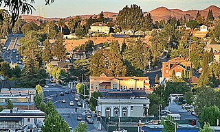
Anderson is a city in Shasta County, California, approximately 10 miles south of Redding. Its population is 11,323 as of the 2020 census, up from 9,932 from the 2010 census.

Contents

Located 138 miles north of Sacramento, the city's roots are as a railroad town near the northern tip of the Central Valley of California.

The city was named after ranch owner Elias Anderson, who granted the Oregon and California Railroad trackage rights and land for a station. [4] Elias Anderson was a farmer, hotel owner, and postmaster. Elias married Elizabeth Summers in 1839 and built the Prairie House in the community of Cottonwood in 1856 on the south side of Cottonwood Creek (now Tehama County).

Elias Anderson purchased the American Ranch from Thomas Freeman in 1856 and built the American Ranch Hotel in what would become downtown Anderson, California. The post office was inside the hotel. Elias Anderson purchased 210 acres from Pierson B. Reading in 1865 and deeded a right-of-way through his property to Central Pacific Railroad in 1872; in return the railroad gave the depot his name. Elias and Elizabeth Anderson built their new home at 2865 East Street in 1873; it no longer exists. While it stood, the house was designated as California Historical Landmark No. 12. In 1876 the Andersons moved their ranch hotel to the corner of Main and Ferry Streets.

History

Anderson was originally a part of Rancho Buena Ventura, a Mexican-era rancho granted by Governor Manuel Micheltorena to Pierson B. Reading. Map of Rancho Buena Ventura (modern day Redding, California).png
Anderson was originally a part of Rancho Buena Ventura, a Mexican-era rancho granted by Governor Manuel Micheltorena to Pierson B. Reading.

Railroad activity came to the area in 1872. Anderson is named after Elias Anderson, who owned the largest land grant in the vicinity. The city's Anderson River Park sits on part of the original land grant owned by Anderson. [5]

Geography

Anderson is located at 40°27′08″N122°17′48″W / 40.452092°N 122.296560°W / 40.452092; -122.296560 . [6]

According to the United States Census Bureau, the city has a total area of 6.6 square miles (17 km2), of which 6.4 square miles (17 km2) of it is land and 0.2 square miles (0.52 km2) of it (3.74%) is water.

Climate

According to the Köppen Climate Classification system, Anderson has a Hot-summer Mediterranean climate, abbreviated "Csa" on climate maps. [7]

Demographics

Historical population
CensusPop.Note
1890 508
1960 4,492
1970 5,49222.3%
1980 7,38134.4%
1990 8,29912.4%
2000 9,0228.7%
2010 9,93210.1%
2020 11,32314.0%
U.S. Decennial Census [8]

2010

At the 2010 census Anderson had a population of 9,932. The population density was 1,500.3 inhabitants per square mile (579.3/km2). The racial makeup of Anderson was 8,273 (83.3%) White, 70 (0.7%) African American, 426 (4.3%) Native American, 256 (2.6%) Asian, 17 (0.2%) Pacific Islander, 353 (3.6%) from other races, and 537 (5.4%) from two or more races. Hispanic or Latino of any race were 1,070 persons (10.8%). [9]

The census reported that 9,920 people (99.9% of the population) lived in households, 12 (0.1%) lived in non-institutionalized group quarters, and no one was institutionalized.

There were 3,944 households, 1,453 (36.8%) had children under the age of 18 living in them, 1,503 (38.1%) were opposite-sex married couples living together, 771 (19.5%) had a female householder with no husband present, 254 (6.4%) had a male householder with no wife present. There were 364 (9.2%) unmarried opposite-sex partnerships, and 25 (0.6%) same-sex married couples or partnerships. 1,163 households (29.5%) were one person and 490 (12.4%) had someone living alone who was 65 or older. The average household size was 2.52. There were 2,528 families (64.1% of households); the average family size was 3.07.

The age distribution was 2,746 people (27.6%) under the age of 18, 934 people (9.4%) aged 18 to 24, 2,565 people (25.8%) aged 25 to 44, 2,420 people (24.4%) aged 45 to 64, and 1,267 people (12.8%) who were 65 or older. The median age was 34.1 years. For every 100 females, there were 87.6 males. For every 100 females age 18 and over, there were 82.2 males.

There were 4,211 housing units at an average density of 636.1 per square mile, of the occupied units 1,888 (47.9%) were owner-occupied and 2,056 (52.1%) were rented. The homeowner vacancy rate was 2.8%; the rental vacancy rate was 4.6%. 4,727 people (47.6% of the population) lived in owner-occupied housing units and 5,193 people (52.3%) lived in rental housing units.

2000

At the 2000 census there were 9,022 people in 3,372 households, including 2,319 families, in the city. The population density was 1,412.0 inhabitants per square mile (545.2/km2). There were 3,579 housing units at an average density of 560.2 per square mile (216.3/km2). The racial makeup of the city was 86.51% White, 0.62% African American, 4.13% Native American, 1.77% Asian, 0.12% Pacific Islander, 2.33% from other races, and 4.51% from two or more races. Hispanic or Latino of any race were 7.30%. [10]

Of the 3,372 households 39.3% had children under the age of 18 living with them, 42.6% were married couples living together, 20.2% had a female householder with no husband present, and 31.2% were non-families. 26.5% of households were one person and 12.0% were one person aged 65 or older. The average household size was 2.64 and the average family size was 3.14.

The age distribution was 31.6% under the age of 18, 9.2% from 18 to 24, 27.1% from 25 to 44, 18.3% from 45 to 64, and 13.9% 65 or older. The median age was 32 years. For every 100 females, there were 87.4 males. For every 100 females age 18 and over, there were 79.6 males.

The median income for a household in the city was $24,558, and the median family income was $29,259. Males had a median income of $28,074 versus $20,745 for females. The per capita income for the city was $11,744. About 22.2% of families and 28.3% of the population were below the poverty line, including 43.3% of those under age 18 and 9.5% of those age 65 or over.

According to a 2006 estimate, the population is 10,677. The report by the California Department of Finance lists the annual percentage change population estimate at 1.4%. [11]

In 2007, the population dropped from 10,677 to 10,580.

In areas north of Anderson, 4,036 live in unincorporated urban areas along Highway 273. Another 8,342 live in rural areas, including at least 3,500 people in the communities of Olinda and Happy Valley, which is west of Anderson and southwest of Redding. A total of 21,400 people live in the entire Anderson area, including Olinda, Happy Valley, and some areas south of Churn Creek Bottom.

Politics

In the state legislature Anderson is located in the 1st Senate District , represented by Republican Brian Dahle, [12] and the 1st Assembly District , represented by Republican Megan Dahle. [13]

Federally, Anderson is in California's 1st congressional district , represented by Republican Doug LaMalfa. [14]

Economy

Education

High schools

Elementary schools

Recreation

The city is home to Anderson River Park, North Volonte Park, and South Volonte Park.

Anderson River Park

Anderson River Park is located off of Stingy Ln. down Rupert Rd. The park is situated on the Sacramento River. The park consists of athletic fields, picnic areas, fishing access, play structures, and a disc golf course.

In fall 2020, the city added River Splash a Splash pad, Shasta County's newest water play park to the park. [15] River Splash has three large shade structures, picnic tables, seating, lawn areas, restrooms, and a 106-feet diameter water play area. The water features include above-ground items such as water spray tunnels, a tipping bucket of water and water jets. All 35 water jets that are cast into the concrete play area have LED lights that are timed with the water spray.

North Volonte Park

North Volonte Park is located off South St. on Emily Rd. North Volonte Park is separated from South Volonte Park. North Volonte Park is a developed park which consists of softball and baseball fields. It also has a skate park.

South Volonte Park

South Volonte Park is located behind North Volonte Park. South Volonte Park is wetlands that are outlined by a jogging trail. It also contains exercise equipment.

Related Research Articles

<span class="mw-page-title-main">Calera, Alabama</span> City in Alabama, United States

Calera is a city in Shelby and Chilton counties in the U.S. state of Alabama. It is the location of the Shelby County Airport.

<span class="mw-page-title-main">Anderson, Alaska</span> City in Alaska, United States

Anderson is a city in the Denali Borough, Alaska, United States, and the borough's only incorporated community. At the 2010 census the population was 246, down from 367 at the 2000 census. At the 2020 census, the population dropped to 177 residents. The city is named after one of the original homesteaders.

<span class="mw-page-title-main">Rail Road Flat, California</span> Census-designated place in California, United States

Rail Road Flat is a census-designated place (CDP) in Calaveras County, California, United States. The population was 475 at the 2010 census, down from 549 at the 2000 census.

<span class="mw-page-title-main">Knightsen, California</span> Census-designated place in California, United States

Knightsen is a census-designated place (CDP) in Contra Costa County, California, in the United States. As of the 2010 census, the CDP population was 1,568, up from 861 reported in the 2000 census.

<span class="mw-page-title-main">Pinole, California</span> City in California, United States

Pinole is a city in Contra Costa County, California, United States. The population was 19,022 at the 2020 census.

<span class="mw-page-title-main">Firebaugh, California</span> City in Fresno County, California, United States

Firebaugh is a city in Fresno County, California, United States, on the west side of the San Joaquin River 38 miles (61 km) west of Fresno.

<span class="mw-page-title-main">Kingsburg, California</span> City in California, United States

Kingsburg is a city in Fresno County, California. Kingsburg is located 5 miles (8 km) southeast of Selma at an elevation of 302 feet, on the banks of the Kings River. The city is 21 miles (34 km) from Fresno, and about 130 miles (210 km) from the California Central Coast and Sierra Nevada mountain range. The population was 12,380 at the 2020 census.

<span class="mw-page-title-main">Rosamond, California</span> Unincorporated community in Kern County, California

Rosamond is an unincorporated community in Kern County, California, US, near the Los Angeles county line. Rosamond is part of Greater Los Angeles and is located in the Mojave Desert just north of Lancaster and Palmdale, two of the largest cities in Antelope Valley. As of the 2010 Census, Rosamond's population was 18,150. For statistical purposes, the United States Census Bureau has defined Rosamond as a census-designated place (CDP).

<span class="mw-page-title-main">Roseville, California</span> City in California, United States

Roseville is the most populous city in Placer County, California, located within the Sacramento metropolitan area. As of 2019, the US Census Bureau estimated the city's population to be 141,500. Interstate 80 runs through Roseville and State Route 65 runs through part of the northern edge of the city.

<span class="mw-page-title-main">Montague, California</span> City in California, United States

Montague is a city in Siskiyou County, California, United States. Its population is 1,226 as of the 2020 census, down from 1,443 from the 2010 census.

<span class="mw-page-title-main">Suisun City, California</span> City in California, United States

Suisun City is a city in Solano County, California, United States. The population was 29,518 at the 2020 census.

<span class="mw-page-title-main">Tuolumne City, California</span> Census-designated place in California, United States

Tuolumne City is an unincorporated town in Tuolumne County, California. A census-designated place (CDP) officially known as Tuolumne also encompasses the town. The population of the CDP was 1,779 at the 2010 census, down from 1,865 at the 2000 census.

<span class="mw-page-title-main">Lisbon, Connecticut</span> Town in Connecticut, United States

Lisbon is a town in New London County, Connecticut, United States, 7.3 miles (11.7 km) by road northeast of Norwich. The town is part of the Southeastern Connecticut Planning Region. The population was 4,195 at the 2020 census. The town center is also known as the village of Newent. The town school is Lisbon Central School. Its only postal code, 06351, is Jewett City, Connecticut, which is a village of the town of Griswold, Connecticut and encompasses all of Lisbon and Griswold.

<span class="mw-page-title-main">Astor, Florida</span> Census-designated place in Florida, United States

Astor is an unincorporated community and census-designated place (CDP) in Lake County, Florida, United States, located on the west side of the St. Johns River between Lake George and Lake Dexter. The community straddles State Road 40, with the community of Volusia in Volusia County across the St. Johns to the east and Astor Park to the west. The population was 1,556 at the 2010 census. It is part of the Orlando–Kissimmee–Sanford Metropolitan Statistical Area.

<span class="mw-page-title-main">Union City, Indiana</span> City in Indiana, United States

Union City is a city in Wayne Township, Randolph County, Indiana, United States. As of the 2020 census, the city had a population of 3,454.

<span class="mw-page-title-main">Garnett, Kansas</span> City in Anderson County, Kansas

Garnett is a city in and the county seat of Anderson County, Kansas, United States. As of the 2020 census, the population of the city was 3,242.

<span class="mw-page-title-main">Union City, Ohio</span> Village in Ohio, United States

Union City is a village in Darke County, Ohio, United States. The population was 1,582 at the 2020 census. It is directly across the state line from its twin city of Union City, Indiana.

<span class="mw-page-title-main">Bridgewater, South Dakota</span> City in South Dakota, United States

Bridgewater is a city in southeastern McCook County, South Dakota, United States. The population was 511 at the 2020 census.

<span class="mw-page-title-main">Mullens, West Virginia</span> City in West Virginia, United States

Mullens is a city in Wyoming County, West Virginia. The population was 1,475 at the time of the 2020 census.

<span class="mw-page-title-main">Medford, Wisconsin</span> City in Wisconsin, United States

Medford is a city and county seat of Taylor County, in north-central Wisconsin, United States. The population was 4,349 at the 2020 census. The city is located mostly within the boundaries of the Town of Medford.

References

  1. "City of Anderson" . Retrieved July 29, 2018.
  2. "California Cities by Incorporation Date". California Association of Local Agency Formation Commissions. Archived from the original (Word) on November 3, 2014. Retrieved August 25, 2014.
  3. "2020 U.S. Gazetteer Files". United States Census Bureau. Retrieved October 30, 2021.
  4. Gudde, Erwin; William Bright (2004). California Place Names (Fourth ed.). University of California Press. p. 12. ISBN   978-0-520-24217-3.
  5. Northern California. Heathrow, Florida: AAA Publishing. 2012. p. 45.
  6. "US Gazetteer files: 2010, 2000, and 1990". United States Census Bureau. February 12, 2011. Retrieved April 23, 2011.
  7. Climate Summary for Anderson, California
  8. "Census of Population and Housing". Census.gov. Retrieved June 4, 2015.
  9. "2010 Census Interactive Population Search: CA - Anderson city". U.S. Census Bureau. Archived from the original on January 31, 2016. Retrieved July 12, 2014.
  10. "U.S. Census website". United States Census Bureau . Retrieved January 31, 2008.
  11. State of California, Department of Finance, E-1 Population Estimates for Cities, Counties and State with Annual Percent Change — January 1, 2005, and 2006. Sacramento, California, May 2006.
  12. "Senators". State of California. Retrieved March 10, 2013.
  13. "Members Assembly". State of California. Retrieved March 2, 2013.
  14. "California's 1st Congressional District - Representatives & District Map". Civic Impulse, LLC. Retrieved March 1, 2013.
  15. "News Article". KRCR. Retrieved May 19, 2020.