Cottonwood, California

Last updated

Cottonwood
Cottonwood, Shasta County, August 2022-8336.jpg
Front Street in Cottonwood, August 2022
Shasta County California Incorporated and Unincorporated areas Cottonwood Highlighted.svg
Location in Shasta County and the state of California
Coordinates: 40°23′20″N122°16′55″W / 40.38889°N 122.28194°W / 40.38889; -122.28194
Country Flag of the United States.svg  United States
State Flag of California.svg  California
County Shasta
Area
[1]
  Total13.22 sq mi (34.25 km2)
  Land13.22 sq mi (34.25 km2)
  Water0.00 sq mi (0.00 km2)  0%
Elevation
420 ft (132 m)
Population
 (2020)
  Total6,268
  Density473.95/sq mi (183.00/km2)
Time zone UTC-8 (Pacific (PST))
  Summer (DST) UTC-7 (PDT)
ZIP code
96022
Area code 530
FIPS code 06-16630
GNIS feature ID0277493

Cottonwood is a census-designated place (CDP) in Shasta County, California, United States. Its population is 6,268 as of the 2020 census, up from 3,316 from the 2010 census. [2] Cottonwood was a stagecoach town where a settlement was established in 1849. The first Post Office was opened in 1852. Cottonwood is equidistant between Redding and Red Bluff, 15 miles (24 km) in either direction. It is 4 miles (6.4 km) south of Anderson.

Contents

In the spring of 1997 Hollywood came to this small, quiet town to film Almost Heroes starring Matthew Perry and Chris Farley. It was Farley's last film.

In the summer of 1961, parts of Hell Is for Heroes , starring Steve McQueen, were shot in and around Cottonwood. Bob Newhart made his debut appearance in this film.

Geography

Cottonwood was originally a part of Rancho Buena Ventura, a Mexican-era rancho granted by Governor Manuel Micheltorena to Pierson B. Reading. Map of Rancho Buena Ventura (modern day Redding, California).png
Cottonwood was originally a part of Rancho Buena Ventura, a Mexican-era rancho granted by Governor Manuel Micheltorena to Pierson B. Reading.

Cottonwood is located at 40°23′20″N122°16′55″W / 40.38889°N 122.28194°W / 40.38889; -122.28194 (40.388953, −122.281823). [3]

According to the United States Census Bureau, the CDP has a total area of 2.3 square miles (6.0 km2), all of it land.

Cottonwood is located on the north and south bank of Cottonwood Creek, for which it is named.

Demographics

Historical population
CensusPop.Note
2020 6,268
U.S. Decennial Census [4]

2010

The 2010 United States Census [5] reported that Cottonwood had a population of 3,316. The population density was 1,433.0 inhabitants per square mile (553.3/km2). The racial makeup of Cottonwood was 2,844 (85.8%) White, 4 (0.1%) African American, 99 (3.0%) Native American, 108 (3.3%) Asian, 2 (0.1%) Pacific Islander, 120 (3.6%) from other races, and 139 (4.2%) from two or more races. Hispanic or Latino of any race were 352 persons (10.6%).

The Census reported that 3,316 people (100% of the population) lived in households, 0 (0%) lived in non-institutionalized group quarters, and 0 (0%) were institutionalized.

There were 1,200 households, out of which 500 (41.7%) had children under the age of 18 living in them, 591 (49.3%) were opposite-sex married couples living together, 200 (16.7%) had a female householder with no husband present, 102 (8.5%) had a male householder with no wife present. 240 households (20.0%) were made up of individuals, and 80 (6.7%) had someone living alone who was 65 years of age or older. The average household size was 2.76. There were 893 families (74.4% of all households); the average family size was 3.14.

The population was spread out, with 950 people (28.6%) under the age of 18, 299 people (9.0%) aged 18 to 24, 805 people (24.3%) aged 25 to 44, 910 people (27.4%) aged 45 to 64, and 352 people (10.6%) who were 65 years of age or older. The median age was 35.8 years. For every 100 females, there were 94.1 males. For every 100 females age 18 and over, there were 91.1 males.

There were 1,306 housing units at an average density of 564.4 per square mile (217.9/km2), of which 759 (63.3%) were owner-occupied, and 441 (36.8%) were occupied by renters. The homeowner vacancy rate was 4.3%; the rental vacancy rate was 7.7%. 2,093 people (63.1% of the population) lived in owner-occupied housing units and 1,223 people (36.9%) lived in rental housing units.

2000

As of the census [6] of 2000, there were 2,960 people, 1,068 households, and 776 families residing in the CDP. The population density was 1,237.2 inhabitants per square mile (477.7/km2). There were 1,131 housing units at an average density of 472.7 per square mile (182.5/km2). The racial makeup of the CDP was 86.32% White, 0.24% African American, 3.21% Native American, 3.04% Asian, 0.03% Pacific Islander, 3.34% from other races, and 3.82% from two or more races. Hispanic or Latino of any race were 9.39% of the population.

There were 1,068 households, out of which 42.6% had children under the age of 18 living with them, 51.5% were married couples living together, 16.3% had a female householder with no husband present, and 27.3% were non-families. 22.0% of all households were made up of individuals, and 8.7% had someone living alone who was 65 years of age or older. The average household size was 2.77 and the average family size was 3.22.

In the CDP, the population was spread out, with 32.1% under the age of 18, 8.7% from 18 to 24, 29.0% from 25 to 44, 19.4% from 45 to 64, and 10.8% who were 65 years of age or older. The median age was 33 years. For every 100 females, there were 89.9 males. For every 100 females age 18 and over, there were 87.2 males.

The median income for a household in the CDP was $30,191, and the median income for a family was $31,808. Males had a median income of $31,161 versus $20,755 for females. The per capita income for the CDP was $11,778. About 12.0% of families and 18.3% of the population were below the poverty line, including 21.3% of those under age 18 and 3.8% of those age 65 or over.

Politics

In the state legislature Cottonwood is located in the 1st Senate District , represented by Republican Brian Dahle, [7] and the 1st Assembly District , represented by Republican Megan Dahle. [8]

Federally, Cottonwood is in California's 1st congressional district , represented by Republican Doug LaMalfa. [9]

Proposed incorporation

A number of residents in Cottonwood[ who? ] have expressed interest in incorporation. Not only would it allow the town to have stricter building codes, but it would stop the City of Anderson from further annexation of the surrounding areas. [10]

Cottonwood is one of five CDPs in Shasta County that have expressed interest in incorporating. The other towns are Burney, Shingletown, Fall River Mills, and McArthur. Fall River Mills and McArthur would incorporate as one city together.

A suggestion for combining the new Sunset Hills and Sun City Tehama subdivisions across the Tehama County line with the current CDP would be currently unworkable since the California constitution prohibits incorporated cities and towns from crossing county lines. [11]

Education

Cottonwood has one high school, one junior high school, two elementary schools.

West Valley High School (9–12), with an enrollment of approximately 900 students. West Cottonwood Junior High School (5–8) North Cottonwood (k–4) Cottonwood Creek Charter (K-8) with an approximate enrollment of 250 students.

There are three elementary schools, Cottonwood Creek Charter for K-8 and North Cottonwood Elementary for 3–5 on the Shasta side, and Evergreen Elementary on the Tehama side.

There are two public middle schools, West Cottonwood Jr High on the Shasta side and Evergreen Middle on the Tehama side. A school that was recently added as a charter school is Cottonwood Creek Charter.

Notable residents

Chris Farley filmed his last movie, Almost Heroes in Cottonwood. The scenes were shot on the Sacramento River.

Related Research Articles

<span class="mw-page-title-main">Sun Lakes, Arizona</span> CDP in Maricopa County, Arizona

Sun Lakes is an unincorporated community and census-designated place (CDP) in Maricopa County, Arizona, United States. The population was 14,868 at the 2020 census. Sun Lakes is an active adult community comprising five country club communities in three homeowner associations. These include the gated communities of Oakwood and IronWood (IronOaks), the gated and non-gated communities of Palo Verde and Cottonwood, and the non-gated community of Sun Lakes 1. Sun Lakes is a master-planned community developed by Robson Communities.

<span class="mw-page-title-main">Oroville East, California</span> Census-designated place in California, United States

Oroville East or Kelly Ridge is a census-designated place (CDP) in Butte County, California, United States. The population was 8,280 at the 2010 census, down from 8,680 at the 2000 census. Most citizens are dependent on the commerce of Oroville, and the vast majority of high school students in Kelly Ridge attend Las Plumas High School. The community of Kelly Ridge sits at Lake Oroville and offers direct access to boating, camping, fishing and a variety of water sports.

<span class="mw-page-title-main">Tamalpais-Homestead Valley, California</span> Census-designated place in California, United States

Tamalpais-Homestead Valley is a census-designated place (CDP) in Marin County, California, United States. The population was 11,492 at the 2020 census.

<span class="mw-page-title-main">Anderson, California</span> City in California, United States

Anderson is a city in Shasta County, California, approximately 10 miles south of Redding. Its population is 11,323 as of the 2020 census, up from 9,932 from the 2010 census.

<span class="mw-page-title-main">French Gulch, California</span> Census-designated place in California, United States

French Gulch is a census-designated place (CDP) in Shasta County, California, United States. Its population is 373 as of the 2020 census, up from 346 from the 2010 census.

<span class="mw-page-title-main">Millville, California</span> Census-designated place in California, United States

Millville is a census-designated place (CDP) in Shasta County, California, United States. Its population is 724 as of the 2020 census, down from 727 from the 2010 census.

<span class="mw-page-title-main">Shingletown, California</span> Census-designated place in California, United States

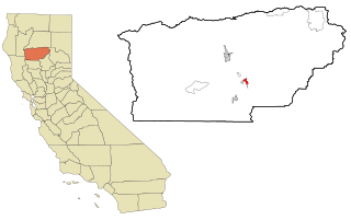
Shingletown is a census-designated place (CDP) in Shasta County, California, United States. Its population is 2,442 as of the 2020 census, up from 2,283 from the 2010 census.

<span class="mw-page-title-main">McCloud, California</span> Census-designated place in California

McCloud is a small town and census-designated place (CDP) in Siskiyou County, California, United States. Its population is 945 as of the 2020 census, down from 1,101 from the 2010 census.

<span class="mw-page-title-main">Los Molinos, California</span> Census-designated place in California, United States

Los Molinos is a census-designated place (CDP) in Tehama County, California, United States. The population was 2,037 at the 2010 census, up from 1,952 at the 2000 census.

<span class="mw-page-title-main">Manton, California</span> Census-designated place in California, United States

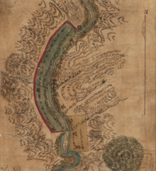
Manton is a census-designated place (CDP) partially in Tehama County, California, United States. It is also in Shasta County. The population in the Tehama County portion was 347 at the 2010 census, down from 372 at the 2000 census.

<span class="mw-page-title-main">Mineral, California</span> Census designated place in California, United States

Mineral is a boundaried but unincorporated forest village in Tehama County, California, United States. It has been part of a much larger census-designated place since 1980, for which the population was 123 at the 2010 census, down from 143 at the 2000 census.

<span class="mw-page-title-main">Tehama, California</span> City in California, United States

Tehama is a city in Tehama County, California, United States. The population was 418 at the 2010 census, down from 432 at the 2000 census.

<span class="mw-page-title-main">Verde Village, Arizona</span> CDP in Yavapai County, Arizona

Verde Village is a census-designated place (CDP) in Yavapai County, Arizona, United States. The population was 11,605 at the 2010 census. It is a retirement and bedroom community for Cottonwood.

<span class="mw-page-title-main">Montgomery Creek, California</span> Census-designated place in California, United States

Montgomery Creek is a census-designated place in Shasta County, California, United States. Its population is 176 as of the 2020 census, up from 163 from the 2010 census. The town and associated creek were named after Zachariah Montgomery.

<span class="mw-page-title-main">Rancho Tehama, California</span> Census-designated place in California, United States

Rancho Tehama, also known as the Rancho Tehama Reserve, is an unincorporated community in Tehama County, California, United States. As of the 2020 census, the population of the community and nearby areas was 1,572. The lightly populated rural, remote community has large lots where some residents farm olives, walnuts and almonds.

Cottonwood West was a census-designated place (CDP) in Salt Lake County, Utah, United States. The CDP was situated between the cities of Holladay and Murray, which by the mid-2000s had annexed virtually all of the area between them.

<span class="mw-page-title-main">Gerber, California</span> Census-designated place in California, United States

Gerber is a census-designated place (CDP) in Tehama County, California. Gerber sits at an elevation of 226 feet (69 m). The 2020 United States census reported Gerber's population was 1,044.

<span class="mw-page-title-main">Lakehead, California</span> Census-designated place in California, United States

Lakehead is a census-designated place (CDP) in Shasta County, California. Lakehead sits at an elevation of 1,447 feet (441 m). Lakehead is located halfway between Seattle and Los Angeles. Its population is 469 as of the 2020 census, up from 461 from the 2010 census.

<span class="mw-page-title-main">Lake California, California</span> Census-designated place in California, United States

Lake California is a census-designated place (CDP) in Tehama County, California. Lake California sits at an elevation of 597 feet (182 m). The 2010 United States census reported Lake California's population was 3,054.

Las Flores is a census-designated place (CDP) in Tehama County, California. Las Flores sits at an elevation of 249 feet (76 m). The 2010 United States census reported Las Flores's population was 187.

References

  1. "2020 U.S. Gazetteer Files". United States Census Bureau. Retrieved October 30, 2021.
  2. "QuickFacts: Cottonwood CDP, California". U.S. Census Bureau. Retrieved January 22, 2022.
  3. "US Gazetteer files: 2010, 2000, and 1990". United States Census Bureau. February 12, 2011. Retrieved April 23, 2011.
  4. "Census of Population and Housing". Census.gov. Retrieved June 4, 2016.
  5. "2010 Census Interactive Population Search: CA – Cottonwood CDP". U.S. Census Bureau. Archived from the original on July 15, 2014. Retrieved July 12, 2014.
  6. "U.S. Census website". United States Census Bureau . Retrieved January 31, 2008.
  7. "Senators". State of California. Retrieved March 10, 2013.
  8. "Members Assembly". State of California. Retrieved March 2, 2013.
  9. "California's 1st Congressional District - Representatives & District Map". Civic Impulse, LLC. Retrieved March 1, 2013.
  10. Woodward, Michael (June 27, 2007). "The City of Cottonwood: A pipe dream or planning ahead?". Anderson Valley Post. Archived from the original on November 21, 2008. Retrieved July 11, 2017.
  11. CALIMESA: Housing slump stalls growth – Press Enterprise
  12. Schultz, Jim (May 8, 2009). "Country guitarist Norm Stephens dies in Cottonwood". Redding Record Searchlight. Archived from the original on May 10, 2009. Retrieved July 11, 2017.
  13. USA Track & Field: Nicole Teter