
The Bass Coast Shire is a local government area in Victoria, Australia, located in the southeastern part of the state. It covers an area of 866 square kilometres (334 sq mi) and in June 2018 had a population of 35,327. It includes the towns of Bass, Cape Paterson, Cape Woolamai, Corinella, Coronet Bay, Cowes, Inverloch, Kilcunda, Lang Lang, Newhaven, Rhyll, San Remo, Summerlands and Wonthaggi as well as the historic locality of Krowera. It also includes the popular tourist destination Phillip Island. It was formed in 1994 from the amalgamation of the Shire of Bass, Shire of Phillip Island, Borough of Wonthaggi, parts of the Shire of Woorayl, Shire of Korumburra and City of Cranbourne.

Western Port, commonly but unofficially known as Western Port Bay, is a large tidal bay in southern Victoria, Australia, opening into Bass Strait. It is the second largest bay in the state. Geographically, it is dominated by two large islands; French Island and Phillip Island. At the time it was renamed, its position was west of other known ports and bays, but Western Port has become something of a misnomer as it lies just to the east of the larger Port Phillip and the city of Melbourne. It is visited by Australian fur seals, whales and dolphins, as well as many migratory waders and seabirds. It is listed under the Ramsar Convention as a wetland of international significance.

Inverloch is a seaside town located in Victoria, Australia and the most populous city of the Bass Coast Shire. It is located 143 kilometres (89 mi) south east of Melbourne via the South Gippsland Highway on the Bass Highway in the Bass Coast Shire of Gippsland, Victoria, Australia. Known originally for the calm waters of Anderson Inlet, it is now also known for the discovery of Australia's first dinosaur bone.

The Ninety Mile Beach is a sandy stretch of beach on the south-eastern coastline of the East Gippsland region of Victoria in Australia. The beach faces Bass Strait and backs the Gippsland Lakes. The beach is just over 151 kilometres (94 mi) in length, running north-eastward from a spit near Port Albert to the man-made channel at Lakes Entrance.

The Gippsland Lakes are a network of coastal lakes, marshes and lagoons in East Gippsland, Victoria, Australia covering an overall area of about 354 km2 (137 sq mi) between the rural towns of Lakes Entrance, Bairnsdale and Sale. The largest of the lakes are Lake Wellington, Lake King and Lake Victoria. The lakes are collectively fed by the Avon, Thomson, Latrobe, Mitchell, Nicholson and Tambo Rivers, and drain into the Bass Strait through a short canal about 2 km (1.2 mi) southwest of Lakes Entrance town centre.
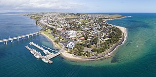
Wonthaggi is a seaside town located 132 kilometres (82 mi) south east of Melbourne via the South Gippsland and Bass Highways, in the Bass Coast Shire of Gippsland, Victoria, Australia. Known originally for its coal mining, it is now the largest town in South Gippsland, a regional area with extensive tourism, beef and dairy industries.

Port Albert is a coastal town in Victoria, Australia, on the coast of Corner Inlet on the Yarram - Port Albert Road, 82 kilometres (51 mi) south-east of Morwell, 236 kilometres (147 mi) south-east of Melbourne, in the Shire of Wellington. At the 2016 census, Port Albert had a population of 293.
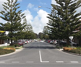
San Remo is a town in southern Victoria, Australia in the Gippsland region. Formed as a fishing village, its economy is now largely based on tourism. It is also notable as the town on the mainland end of the Phillip Island Bridge to Phillip Island. At the 2021 census, San Remo had a population of 1,700.
Kilcunda is a seaside town located 117 kilometres (73 mi) south east of Melbourne between Phillip Island and Wonthaggi near Dalyston via the South Gippsland Highway on the Bass Highway, in the Bass Coast Shire of Gippsland, Victoria, Australia. Known originally as a train station near Wonthaggi, it is now the location of a very popular swimming hole at the Bourne Creek Trestle Bridge and at the 2016 census, Kilcunda had a population of 396.

The Great Southern Rail Trail is a 109-kilometre rail trail from Nyora to Welshpool in South Gippsland, Victoria, Australia. Sections of the trail are flat or gently undulating trail through lush dairy farmland, areas of remnant bush and lowland scrub. There is a big climb on the section between Loch and Leongatha. The section between Fish Creek and Foster climbs past Mount Hoddle and goes through dense forest with occasional magnificent views of Wilsons Promontory and Corner Inlet.

Sunday Island is a low-lying, sandy, 16.2 km2 barrier island on the coast of Victoria, Australia. It is about 8 km long by 3 km wide and rises to a maximum height of no more than 15 m above mean sea level. It lies in Corner Inlet, South Gippsland, 4 km south-west of Port Albert and 215 km south-east of Melbourne. Although the island is surrounded by the Nooramunga Marine and Coastal Park, it is private freehold property, a game reserve owned by the Para Park Co-operative Game Reserve Limited. It contains an airstrip and a jetty as well as accommodation buildings for resident caretakers, visiting members, and their guests.

Cape Paterson is a cape and seaside village located near the town of Wonthaggi, 132 kilometres (82 mi) south-east of Melbourne via the South Gippsland and Bass Highways, in the Bass Coast Shire of Gippsland, Victoria, Australia. Known originally for the discovery of coal by William Hovell in 1826, it is now extremely popular for its beaches and rockpool and at the 2011 census, it had a population of 718.
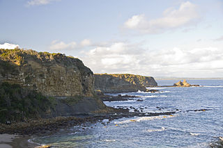
The Bunurong Marine National Park is a protected marine national park located off the coast of Cape Paterson in the South Gippsland region of Victoria, Australia. The 2,100-hectare (5,200-acre) marine national park is located about 6 kilometres (3.7 mi) southwest of Inverloch and about 5 kilometres (3.1 mi) off the coastline. The coastal waters protect a range of habitats including intertidal reefs, subtidal rocky reefs, algal gardens and seagrass beds. The waters are cool, akin to Victoria’s central and western coasts. However, they are relatively protected from south-westerly swells due to the location of far away King Island, Tasmania.
Snake Island is a sand island, located in Corner Inlet in the Gippsland region of Victoria, Australia. It has an area of 35-square-kilometre (14 sq mi) and is the largest island in Corner Inlet. Snake Island lies within the Nooramunga Marine and Coastal Park and is part of a complex of barrier islands that protect a large marine embayment from the pounding waves of Bass Strait. The Aboriginal Gunai name for the island is Negima.

The Corner Inlet is a 600-square-kilometre (230 sq mi) bay located 200 kilometres (120 mi) south-east of Melbourne in the South Gippsland region of Victoria, Australia. Of Victoria's large bays it is both the easternmost and the warmest. It contains intertidal mudflats, mangroves, salt marsh and seagrass meadows, sheltered from the surf of Bass Strait by a complex of 40 sandy barrier islands, the largest of which are Snake, Sunday and Saint Margaret Islands.
Shallow Inlet is a marine inlet, opening onto Waratah Bay on the western side of the Yanakie Isthmus in South Gippsland, Victoria, south-eastern Australia. It lies close to the small holiday communities of Sandy Point and Yanakie, as well as to Wilsons Promontory and the Wilsons Promontory National Park.
McLoughlins Beach is a small settlement in South Gippsland, Victoria. It has an estimated permanent population of less than 300 and a number of holiday houses.

Dalyston is a seaside town located 125 kilometres (78 mi) south east of Melbourne via the South Gippsland and Bass Highways, in the Bass Coast Shire of Gippsland, Victoria, Australia. Known originally as a train station at Powlett River near Wonthaggi, it is now the location of the Victorian Desalination Plant, and at the 2011 census, it had a population of 606. It's Bass Coast’s fastest-growing suburb, with the 2011 census showing Dalyston’s population more than doubled from 278 residents in 2006 to 606 in 2011.

The Bunurong Marine and Coastal Park collectively are a marine park and a coastal park located along the reef and coast of Harmers Haven, Cape Paterson and Inverloch in the South Gippsland region of Victoria, Australia. Collectively, the parks are located approximately 140 kilometres (87 mi) southeast of Melbourne, between Coal Point in the west to Wreck Creek in the east, and are used for walking, picnicking, boating, education and research.

Wreck Beach is a south-west facing, sandy bay located within the Bunurong Marine Park approximately two kilometres south of the town of Cape Paterson and 132 kilometres (82 mi) south-east of Melbourne via the South Gippsland and Bass Highways, in the Bass Coast Shire of Gippsland, Victoria, Australia.


