
Myanmar is the northwesternmost country of mainland Southeast Asia located on the Indochinese peninsula. With an area of 261,228 sq mi, it is the second largest country in Southeast Asia and the largest on mainland Southeast Asia. The kite-shaped country stretches from 10'N to 20'N for 1,275 miles (2,050 km) with a long tail running along the western coast of the Malay Peninsula.

Victoria is the capital city of the Canadian province of British Columbia, on the southern tip of Vancouver Island off Canada's Pacific coast. The city has a population of 91,867, and the Greater Victoria area has a population of 397,237. The city of Victoria is the 7th most densely populated city in Canada with 4,405.8 inhabitants per square kilometre (11,411/sq mi).

Hawaii is the largest island in the United States, located in the state of Hawaii. It is the southeasternmost of the Hawaiian Islands, a chain of volcanic islands in the North Pacific Ocean. With an area of 4,028 square miles (10,430 km2), it has 63% of the Hawaiian archipelago's combined landmass. However, it has only 13% of Hawaiʻi's population. The island of Hawaiʻi is the third largest island in Polynesia, behind the two main islands of New Zealand.

Bethel Census Area is a census area in the U.S. state of Alaska. As of the 2020 census, the population is 18,666, up from 17,013 in 2010. It is part of the unorganized borough and therefore has no borough seat. Its largest community is the city of Bethel, which is also the largest city in the unorganized borough.
Victoria is the smallest mainland state in Australia. As of 2008 it contained 2,850 separate protected areas with a total land area of 39,273 km2 (15,163 sq mi). Of these, 45 were national parks, totalling 28,023 km2 (10,820 sq mi).
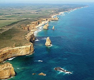
The Port Campbell National Park is a national park in the south-western district of Victoria, Australia. The 1,750-hectare (4,300-acre) national park is situated approximately 190 kilometres (120 mi) south-west of Melbourne and approximately 10 kilometres (6.2 mi) east of Warrnambool. The park is located adjacent to the Great Otway National Park and the Bay of Islands Coastal Park.

Fenwick Island is a coastal resort town in Sussex County, Delaware, United States. According to 2020 census figures, the population of the town is 355, a 2.6% decrease over the last decade. It is part of the Salisbury, Maryland-Delaware Metropolitan Statistical Area. The town is located on Fenwick Island, a barrier spit.

St. Peter Port is a town and one of the ten parishes on the island of Guernsey in the Channel Islands. It is the capital of the Bailiwick of Guernsey as well as the main port. The population in 2019 was 18,958.

Humboldt Lagoons State Park is a California State Park on the Redwood Coast, in Humboldt County, California. It is located along U.S. Route 101 between Trinidad and Orick. The park protects three lagoons with estuaries and wetlands.
Ravine Des Casoars Wilderness Protection Area is a protected area located on the west end of Kangaroo Island in South Australia about 80 km (50 mi) west of Kingscote. It was established in 1993 on land previously part of the Flinders Chase National Park.

Discovery Bay is an open oceanic embayment lying along the coast of eastern South Australia and western Victoria in south-eastern Australia.

South Channel Fort, also known as South Channel Island, is a 0.7 ha artificial island in southern Port Phillip, Victoria, Australia, 6 km north-east of the town of Sorrento. It was part of a network of fortifications protecting the narrow entrance to Port Phillip.

The Deptford culture was an archaeological culture in southeastern North America characterized by the appearance of elaborate ceremonial complexes, increasing social and political complexity, mound burial, permanent settlements, population growth, and an increasing reliance on cultigens.
The Port Phillip Bay and Bellarine Peninsula Ramsar Site is one of the Australian sites listed under the Ramsar Convention as a wetland of international importance. It was designated on 15 December 1982, and is listed as Ramsar Site No.266. Much of the site is also part of either the Swan Bay and Port Phillip Bay Islands Important Bird Area or the Werribee and Avalon Important Bird Area, identified as such by BirdLife International because of their importance for wetland and waterbirds as well as for orange-bellied parrots. It comprises some six disjunct, largely coastal, areas of land, totalling 229 km2, along the western shore of Port Phillip and on the Bellarine Peninsula, in the state of Victoria. Wetland types protected include shallow marine waters, estuaries, freshwater lakes, seasonal swamps, intertidal mudflats and seagrass beds.
The Wilsons Promontory Marine National Park is a protected marine national park located in the South Gippsland region of Victoria, Australia. The 15,500-hectare (38,000-acre) marine park is situated off the southern tip of Wilsons Promontory and extends along the coastline from Norman Bay, near Tidal River, in the west around the southern tip of the promontory to Cape Wellington in the east. It extends offshore to the Glennie and Anser groups of offshore islands.
The Discovery Bay Marine National Park is a protected marine national park located in the Western District of Victoria, Australia The 2,770-hectare (6,800-acre) marine park is located near Portland, and extends along 6 kilometres (3.7 mi) of coastline on the western side of Cape Bridgewater, from Cape Duquesne to Blacks Beach, and offshore 3 nautical miles to the limit of Victorian waters.
Cape Gantheaume is a headland located on the south coast of Kangaroo Island in South Australia. It was named after Vice admiral Honoré Joseph Antoine Ganteaume (1755–1818) by the Baudin expedition to Australia during 1803. It is currently located within the protected area known as the Cape Gantheaume Wilderness Protection Area.

Nepean Bay is a bay located on the north-east coast of Kangaroo Island in the Australian state of South Australia about 130 kilometres south-south-west of Adelaide. It was named by the British navigator, Matthew Flinders, after Sir Evan Nepean on 21 March 1802.
Hardwicke Bay is a bay in the Australian state of South Australia located on the west coast of Yorke Peninsula in Spencer Gulf.

