
Protected areas of South Australia consists of protected areas located within South Australia and its immediate onshore waters and which are managed by South Australian Government agencies. As of March 2018, South Australia contains 359 separate protected areas declared under the National Parks and Wildlife Act 1972, the Crown Land Management Act 2009 and the Wilderness Protection Act 1992 which have a total land area of 211,387.48 km2 (81,617.16 sq mi) or 21.5% of the state's area.
The Lower Glenelg National Park is a national park in the Western District of Victoria, Australia. The 27,300-hectare (67,000-acre) national park is situated approximately 323 kilometres (201 mi) west of Melbourne. The major features of the park are the Glenelg River gorge and the Princess Margaret Rose Cave. Much of the route of the Great South West Walk is located within the national park.
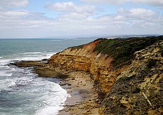
The Port Campbell National Park is a national park in the south-western district of Victoria, Australia. The 1,750-hectare (4,300-acre) national park is situated approximately 190 kilometres (120 mi) south-west of Melbourne and approximately 10 kilometres (6.2 mi) east of Warrnambool. The park is located adjacent to the Great Otway National Park and the Bay of Islands Coastal Park.

Western Port, commonly but unofficially known as Western Port Bay, is a large tidal bay in southern Victoria, Australia, opening into Bass Strait. It is the second largest bay in the state. Geographically, it is dominated by two large islands; French Island and Phillip Island. At the time it was renamed, its position was west of other known ports and bays, but Western Port has become something of a misnomer as it lies just to the east of the larger Port Phillip and the city of Melbourne. It is visited by Australian fur seals, whales and dolphins, as well as many migratory waders and seabirds. It is listed under the Ramsar Convention as a wetland of international significance.

Discovery Bay is an open oceanic embayment lying along the coast of eastern South Australia and western Victoria in south-eastern Australia.

The Port Phillip Heads Marine National Park is a marine protected area located in the vicinity of the bay of Port Phillip, between the Bellarine and Mornington Peninsulas, in Victoria, Australia. The 3,580-hectare (8,800-acre) marine national park comprises six separate sites located approximately 60 kilometres (37 mi) south-west of Melbourne and stretches along 40 kilometres (25 mi) of coastline of Victoria.

Piccaninnie Ponds Conservation Park, formerly the Piccaninnie Ponds National Park, is a protected area of 862 hectares located in southeastern South Australia near Mount Gambier.
The Churchill Island Marine National Park is a protected marine national park located in Western Port, Victoria, Australia. The 670-hectare (1,700-acre) marine park is located south of Rhyll, on the north-eastern shore of Phillip Island, in Western Port.
The Bunurong Marine National Park is a protected marine national park located off the coast of Cape Paterson in the South Gippsland region of Victoria, Australia. The 2,100-hectare (5,200-acre) marine national park is located about 6 kilometres (3.7 mi) southwest of Inverloch and about 5 kilometres (3.1 mi) off the coastline. The coastal waters protect a range of habitats including intertidal reefs, subtidal rocky reefs, algal gardens and seagrass beds. The waters are cool, akin to Victoria’s central and western coasts. However, they are relatively protected from south-westerly swells due to the location of far away King Island, Tasmania.
The Port Phillip Bay and Bellarine Peninsula Ramsar Site is one of the Australian sites listed under the Ramsar Convention as a wetland of international importance. It was designated on 15 December 1982, and is listed as Ramsar Site No.266. Much of the site is also part of either the Swan Bay and Port Phillip Bay Islands Important Bird Area or the Werribee and Avalon Important Bird Area, identified as such by BirdLife International because of their importance for wetland and waterbirds as well as for orange-bellied parrots. It comprises some six disjunct, largely coastal, areas of land, totalling 229 km2, along the western shore of Port Phillip and on the Bellarine Peninsula, in the state of Victoria. Wetland types protected include shallow marine waters, estuaries, freshwater lakes, seasonal swamps, intertidal mudflats and seagrass beds.

The Discovery Bay Coastal Park is a linear protected area of coastal land in western Victoria, south-eastern Australia. The 10,460-hectare (25,800-acre) park extends along the coast of Discovery Bay from Cape Nelson north-westwards for 50 kilometres (31 mi) to the border with South Australia. The park was listed on Australia's now-defunct Register of the National Estate, and lies within the traditional lands of the Gunditjmara people.
The Corner Inlet Marine National Park is a protected marine national park located in the South Gippsland region of Victoria, Australia. The 1,550-hectare (3,800-acre) marine park is situated approximately 200 kilometres (120 mi) southeast of Melbourne and contains part of Corner Inlet.
The Point Addis Marine National Park is a protected marine national park located near Anglesea on the Surf Coast region of Victoria, Australia. The 4,600-hectare (11,000-acre) marine park extends along 10 kilometres (6.2 mi) of coastline east of Anglesea, around Point Addis to the eastern end of Bells Beach and offshore 3 nautical miles to the limit of Victorian waters.
The Point Hicks Marine National Park is a protected marine national park in situated off Point Hicks in the East Gippsland region of Victoria, Australia. The 4,000-hectare (9,900-acre) marine park is situated approximately 450 kilometres (280 mi) east of Melbourne and 25 kilometres (16 mi) south of Cann River, adjacent to the Croajingolong National Park and Point Hicks Lighthouse Reserve.
The Wilsons Promontory Marine National Park is a protected marine national park located in the South Gippsland region of Victoria, Australia. The 15,500-hectare (38,000-acre) marine park is situated off the southern tip of Wilsons Promontory and extends along the coastline from Norman Bay, near Tidal River, in the west around the southern tip of the promontory to Cape Wellington in the east. It extends offshore to the Glennie and Anser groups of offshore islands.

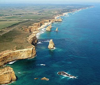
The Twelve Apostles Marine National Park is a protected marine national park located on the south-west coast of Victoria, Australia. The 7,500-hectare (19,000-acre) marine park is situated near Port Campbell and is named after the scenic Twelve Apostles rock stacks, and contains the wreck of the clipper Loch Ard, wrecked on Mutton Bird Island in 1878. The marine park borders Port Campbell and Great Otway National Parks.

The Bunurong Marine and Coastal Park collectively are a marine park and a coastal park located along the reef and coast of Harmers Haven, Cape Paterson and Inverloch in the South Gippsland region of Victoria, Australia. Collectively, the parks are located approximately 140 kilometres (87 mi) southeast of Melbourne, between Coal Point in the west to Wreck Creek in the east, and are used for walking, picnicking, boating, education and research.
The Point Cook Coastal Park covers an area of 863 hectares and includes the Cheetham Wetlands. The park extends from the RAAF Williams Point Cook Base northeast along the coast to the Laverton creek which comprises its northern boundary. The park is approximately 20 kilometres (12 mi) from Melbourne, Australia in a southwesterly direction along Port Phillip Bay. The park is adjoined by the Point Cook Marine Sanctuary, which extends around the point to the south and the east. The northwestern boundary to the park is residential housing.

Lower South East Marine Park is a marine protected area in the Australian state of South Australia located in the state's coastal waters in the state’s south-east adjoining the border with the state of Victoria.

Southern Kangaroo Island Marine Park is a marine protected area in the Australian state of South Australia located in state coastal waters adjoining both the south coast of Kangaroo Island and a group of islets located to the south of Kangaroo Island.
