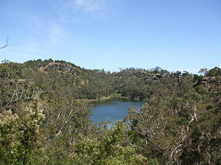
The Budj Bim National Park, formerly known as Mount Eccles National Park, is a national park located in the Western District of Victoria, Australia. The 5,470-hectare (13,500-acre) national park is situated approximately 270 kilometres (170 mi) west of Melbourne and approximately 15 kilometres (9.3 mi) southwest of Macarthur. It derives its name from Budj Bim, formerly Mount Eccles, which is situated in the north-east of the park.
Victoria is the smallest mainland state in Australia. As of 2022 it contained 5,081 separate protected areas with a total land area of 4,012,888 ha.
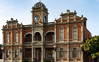
Castlemaine is a town in Victoria, Australia, in the Goldfields region about 120 kilometres northwest by road from Melbourne and about 40 kilometres from the major provincial centre of Bendigo. It is the administrative and economic centre of the Shire of Mount Alexander. The population at the 2021 Census was 7,506. Castlemaine was named by the chief goldfield commissioner, Captain W. Wright, in honour of his Irish uncle, Viscount Castlemaine.

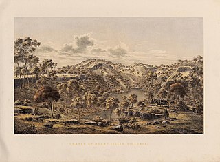
The Victorian gold rush was a period in the history of Victoria, Australia, approximately between 1851 and the late 1860s. It led to a period of extreme prosperity for the Australian colony, and an influx of population growth and financial capital for Melbourne, which was dubbed "Marvellous Melbourne" as a result of the procurement of wealth.
Victoria Park is a 9-hectare (22-acre) urban park situated on the corner of Parramatta Road and City Road, Camperdown, in the City of Sydney, New South Wales, Australia. The park is located adjacent to The University of Sydney and the Broadway Shopping Centre.

Maldon is a town in Victoria, Australia, in the Shire of Mount Alexander local government area. It has been designated "Australia's first notable town" and is notable for its 19th-century appearance, maintained since gold-rush days. At the 2016 census, Maldon had a population of 1,513.
Chewton is a town in central Victoria, Australia in the Shire of Mount Alexander local government area, 116 kilometres north west of the state capital, Melbourne. At the 2016 census, Chewton had a population of 1313.
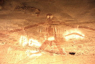
An Australian Aboriginal sacred site is a place deemed significant and meaningful by Aboriginal Australians based on their beliefs. It may include any feature in the landscape, and in coastal areas, these may lie underwater. The site's status is derived from an association with some aspect of social and cultural tradition, which is related to ancestral beings, collectively known as Dreamtime, who created both physical and social aspects of the world. The site may have its access restricted based on gender, clan or other Aboriginal grouping, or other factors.
Australian heritage laws exist at the national (Commonwealth) level, and at each of Australian Capital Territory, New South Wales, Northern Territory, Queensland, South Australia, Tasmania, Victoria, Western Australia state and territory levels. Generally there are separate laws governing Aboriginal cultural heritage and sacred sites, and historical heritage. State laws also allow heritage to be protected through local government regulations, such as planning schemes, as well.
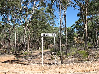
Irishtown is a locality near Castlemaine, Victoria, Australia. It is noted for heritage sites associated with the Victorian Gold Rush, near or within the Castlemaine Diggings National Heritage Park. These include the Red Hill hydraulic gold sluicing site and the Burying Flat Cemetery, also known as Deadmans Gully Burial Ground.

The Goldfields region of Victoria is a region commonly used but typically defined in both historical geography and tourism geography. The region is also known as the Victorian Golden Triangle.
Budj Bim, also known as Mount Eccles, is a dormant volcano near Macarthur in southwestern Victoria, Australia. It lies within the geologically-defined area known as the Newer Volcanics Province, which is the youngest volcanic area in Australia and stretches from western Victoria to south-eastern South Australia.

Australia's National Reserve System (NRS) is a network of more than 10,000 Commonwealth plus state and territory protected areas which, in combination, on a national scale, protect more than 137 million hectares, greater than 17% of the continent, of unique biodiversity and most significant ecological landscapes for future generations. The aim of the NRS is protect the diversity of all native landscapes, flora and fauna across Australia through strategic habitat protection. It consists of public, indigenous and privately protected areas of land and inland freshwaters.
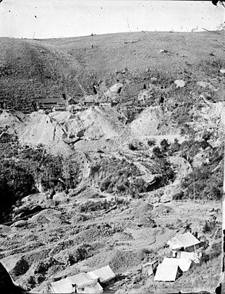
The Jim Crow goldfield was part of the Goldfields region of Victoria, Australia, where gold was mined from the mid- to the late-nineteenth century.
A heritage asset is an item which has value because of its contribution to a nation's society, knowledge and/or culture. Such items are usually physical assets, but some countries also use the term in relation to intangible social and spiritual inheritance.
Budj Bim heritage areas includes several protected areas in Victoria, Australia, the largest two being Budj Bim National Heritage Landscape and the Budj Bim Cultural Landscape. Within the latter, there are three Indigenous Protected Areas: the Tyrendarra Indigenous Protected Area, Kurtonitj Indigenous Protected Area, and the Lake Condah Indigenous Protected Area.

Castlemaine Art Museum is an Australian art gallery and museum in Castlemaine, Victoria in the Shire of Mount Alexander. It was founded in 1913. It is housed in a 1931 Art Deco neo-classical building constructed for the purpose, heritage-listed by the National Trust. Its collection concentrates on Australian art and the museum houses historical artefacts and displays drawn from the district.
Strangways is a locality within the local government area of Mount Alexander, in Central Victoria, Australia. It covers an area of 20.105 square kilometres between the townships of Guidford to the east, Newstead to the north-west and Clydesdale to the south.
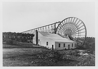
The Garfield water wheel, sometimes referred to as the Forrest Creek Mine water wheel, was a large water wheel used to power a stamper battery at a gold mine near Chewton, Victoria, Australia. Constructed in 1887, the water wheel was used until 1903 and then was dismantled in 1904. There are some remnants at its location.
Philip Clark Ingamells was an Australian conservationist, photographer, writer and advocate for the preservation of parks and wilderness areas who worked for the Victorian National Parks Association (VNPA).

