
The Dandenong Ranges National Park is a national park located in the Greater Melbourne region of Victoria, Australia. The 3,540-hectare (8,700-acre) national park is situated from 31 kilometres (19 mi) at its westernmost points at Ferntree Gully and Boronia to 45 kilometres (28 mi) at it easternmost point at Silvan, east of the Melbourne central business district.

The Oxley Wild Rivers National Park is a protected national park that is located in the Northern Tablelands region of New South Wales, Australia in the Port Macquarie-Hastings City Council and Walcha Shire councils. The 145,223-hectare (358,850-acre) park is situated 445 kilometres (277 mi) north of Sydney and is named in memory of the Australian explorer John Oxley, who passed through the area in 1818 and is one of the largest national parks in New South Wales.

The Werrikimbe National Park is a protected national park located in the catchment zone of the Upper Hastings River in New South Wales, Australia. Gazetted in 1975, the 33,309-hectare (82,310-acre) park is situated approximately 486 kilometres (302 mi) north of Sydney, 65 kilometres (40 mi) north-west of Wauchope, and 90 kilometres (56 mi) east of Walcha on the eastern escarpment of the Great Dividing Range.

The Great Otway National Park is a national park located in the Barwon South West region of Victoria, Australia. The 103,185-hectare (254,980-acre) national park is situated approximately 162 kilometres (101 mi) southwest of Melbourne, in the Otway Ranges, a low coastal mountain range. It contains a diverse range of landscapes and vegetation types.

The Tarra-Bulga National Park is a small national park located in the South Gippsland region of eastern Victoria, Australia approximately 240 kilometres (150 mi) south east of Melbourne. The park is located 33 kilometres (21 mi) south of Traralgon on the Traralgon-Balook Road and 24 kilometres (15 mi) north of Yarram.
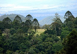
Bunya Mountains is a national park in the South Burnett Region, Queensland, Australia.

Kondalilla is a national park in the Blackall Range of South East Queensland, Australia, 91 km north of Brisbane. William Skene founded this area on his property while searching for lost cattle. He named it Bon Accord before giving it to the Queensland Government who, during the fifties, renamed it Kondalilla which is an Aboriginal word for running water. The area was first officially protected in 1906 as a recreational area, becoming a national park in 1945.

The Springbrook National Park is a protected national park that is located in the Gold Coast hinterland of Queensland, Australia. The 6,197-hectare (15,310-acre) park is situated on the McPherson Range, near Springbrook, approximately 100 kilometres (62 mi) south of Brisbane. The park is part of the Shield Volcano Group of the UNESCO World Heritage–listed Gondwana Rainforests of Australia.

Tamborine is a national park in the Gold Coast hinterland and is a part of the Scenic Rim Regional Council of South East Queensland, Australia, 45 km (28 mi) south of Brisbane.

The Dandenong Ranges are a set of low mountain ranges in Victoria, Australia, approximately 35 km (22 mi) east of the state capital Melbourne. A minor branch of the Great Dividing Range, the Dandenongs consist mostly of rolling hills, rising to 633 m (2,077 ft) at Mount Dandenong, as well as steeply weathered valleys and gullies covered in thick temperate rainforest, predominantly of tall mountain ash trees and dense ferny undergrowth. The namesaked Dandenong Creek and most of its left-bank tributaries originate from headwaters in these mountain ranges. Two of Melbourne's most important storage reservoirs, the Cardinia and Silvan Reservoir, are also located within the Dandenongs.

The McPherson Range is an extensive mountain range, a spur of the Great Dividing Range, heading in an easterly direction from near Wallangarra to the Pacific Ocean coastline. It forms part of the Scenic Rim on the border between the states of New South Wales and Queensland. Further west of the McPherson Range is the Main Range. Towards the coast the range continues into the Border Ranges and other mountainous terrain formed by the Tweed Volcano.
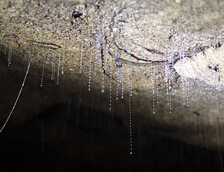
Arachnocampa is a genus of nine fungus gnat species which have a bioluminescent larval stage, akin to the larval stage of glowworm beetles. The species of Arachnocampa are endemic to Australia and New Zealand, dwelling in caves and grottos, or sheltered places in forests.

Spring Gully Conservation Park, formerly the Spring Gully National Park), is a protected area located in the Australian state of South Australia in the localities of Sevenhills and Spring Gully about 6 kilometres (3.7 mi) south of the town centre in Clare.

The Bunya Mountains are a distinctive set of peaks forming an isolated section of the Great Dividing Range in southern Queensland. The mountain range forms the northern edge of the Darling Downs in the locality also called Bunya Mountains near Bell and Dalby. The mountains are south of Kingaroy and just to the south west of Nanango. The range is the remains of a shield volcano which was built from numerous basalt lava flows about 23-24 million years ago.

Cobbler Creek Recreation Park is a 266-hectare (657-acre) protected area located in South Australia about 19 kilometres (12 mi) north of the Adelaide city centre in the suburb of Salisbury East. Originally part of the lands of the Kaurna aboriginal people, it was farmed from European settlement of South Australia until the declaration of the park in 1989.

The Boorganna Nature Reserve is a protected nature reserve located northwest of Taree on the Comboyne Plateau in New South Wales, Australia. The 396-hectare (980-acre) reserve, managed by the NSW National Parks & Wildlife Service, was gazetted in 1904 and is the second oldest nature reserve in the state. The reserve features various forest types, including stands of sub tropical rainforest of which the large rosewood, yellow carabeen and small leaf fig are particularly noteworthy. The reserve is a remnant of the former extensive rainforest on the Comboyne Plateau. The plateau was cleared between 1900 and 1925. Australian red cedar was logged in the area in the nineteenth century. Originally proposed to be part of the world heritage rainforest group. The exploration, knowledge, uses and history of this area by Indigenous Australians is not well known in the present day. Boorganna Nature Reserve was proposed, but rejected for inclusion on the UNESCO World Heritage, due to being geographically isolated from other rainforests in the group.

Polyscias sambucifolia, commonly known as elderberry panax or small basswood, is a species of plant native to eastern Australia.

The Toolangi State Forest region in southern Australia extends from Mount Monda in the south up to Murrindindi in the north and includes the township of Toolangi. The forest is mainly eucalypt forest that has regrown from the 1939 Victoria Bushfires.

Redwoods of the Otway Ranges is a small sheltered grove of Coast Redwoods, Sequoia sempervirens, about 5 kilometres (3 mi) south of Beech Forest in the Otway Ranges in southwestern Victoria, Australia.

