Victoria is the smallest mainland state in Australia. As of 2008 it contained 2,850 separate protected areas with a total land area of 39,273 km2 (15,163 sq mi). Of these, 45 were national parks, totalling 28,023 km2 (10,820 sq mi).
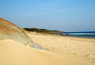
The Croajingolong National Park is a coastal national park located in the East Gippsland region of the Australian state of Victoria. The 88,355-hectare (218,330-acre) national park is situated approximately 450 kilometres (280 mi) east of Melbourne and 500 kilometres (310 mi) south of Sydney.
The Lind National Park is a national park in the East Gippsland region of Victoria, Australia. The 1,370-hectare (3,400-acre) national park is situated approximately 419 kilometres (260 mi) east of Melbourne, adjacent to the Princes Highway between Orbost and Cann River.
The Morwell National Park is a national park located in the western Gippsland region of Victoria, Australia. The 565-hectare (1,400-acre) national park is situated approximately 164 kilometres (102 mi) east of Melbourne via the Princes Highway and 16 kilometres (9.9 mi) south of Morwell in the Strzelecki Ranges. The park preserves a remnant of previously widespread wet sclerophyll forests and some rainforest remnants restricted to deep creek gullies. 320 plant species have been recorded for this park, including five rare or threatened species and 44 orchid species. 129 native fauna species have been recorded, including 19 mammals, 96 birds, 11 reptiles and three amphibians.
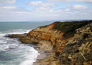
The Port Campbell National Park is a national park in the south-western district of Victoria, Australia. The 1,750-hectare (4,300-acre) national park is situated approximately 190 kilometres (120 mi) south-west of Melbourne and approximately 10 kilometres (6.2 mi) east of Warrnambool. The park is located adjacent to the Great Otway National Park and the Bay of Islands Coastal Park.

The Lakes National Park is a national park in the East Gippsland region of Victoria, Australia. The national park is located approximately 245 km (152 mi) east of the capital city of Melbourne.

The Ninety Mile Beach is a sandy stretch of beach on the south-eastern coastline of the East Gippsland region of Victoria in Australia. The beach faces Bass Strait and backs the Gippsland Lakes. The beach is just over 151 kilometres (94 mi) in length, running north-eastward from a spit near Port Albert to the man-made channel at Lakes Entrance.

The Gippsland Lakes are a network of coastal lakes, marshes and lagoons in East Gippsland, Victoria, Australia covering an overall area of about 354 km2 (137 sq mi) between the rural towns of Lakes Entrance, Bairnsdale and Sale. The largest of the lakes are Lake Wellington, Lake King and Lake Victoria. The lakes are collectively fed by the Avon, Thomson, Latrobe, Mitchell, Nicholson and Tambo Rivers, and drain into the Bass Strait through a short canal about 2 km (1.2 mi) southwest of Lakes Entrance town centre.

The Port Phillip Heads Marine National Park is a marine protected area located in the vicinity of the bay of Port Phillip, between the Bellarine and Mornington Peninsulas, in Victoria, Australia. The 3,580-hectare (8,800-acre) marine national park comprises six separate sites located approximately 60 kilometres (37 mi) south-west of Melbourne and stretches along 40 kilometres (25 mi) of coastline of Victoria.
The Bunurong Marine National Park is a protected marine national park located off the coast of Cape Paterson in the South Gippsland region of Victoria, Australia. The 2,100-hectare (5,200-acre) marine national park is located about 6 kilometres (3.7 mi) southwest of Inverloch and about 5 kilometres (3.1 mi) off the coastline. The coastal waters protect a range of habitats including intertidal reefs, subtidal rocky reefs, algal gardens and seagrass beds. The waters are cool, akin to Victoria’s central and western coasts. However, they are relatively protected from south-westerly swells due to the location of far away King Island, Tasmania.

The Corner Inlet is a 600-square-kilometre (230 sq mi) bay located 200 kilometres (120 mi) south-east of Melbourne in the South Gippsland region of Victoria, Australia. Of Victoria's large bays it is both the easternmost and the warmest. It contains intertidal mudflats, mangroves, salt marsh and seagrass meadows, sheltered from the surf of Bass Strait by a complex of 40 sandy barrier islands, the largest of which are Snake, Sunday and Saint Margaret Islands.
The Corner Inlet Marine National Park is a protected marine national park located in the South Gippsland region of Victoria, Australia. The 1,550-hectare (3,800-acre) marine park is situated approximately 200 kilometres (120 mi) southeast of Melbourne and contains part of Corner Inlet.
The Point Addis Marine National Park is a protected marine national park located near Anglesea on the Surf Coast region of Victoria, Australia. The 4,600-hectare (11,000-acre) marine park extends along 10 kilometres (6.2 mi) of coastline east of Anglesea, around Point Addis to the eastern end of Bells Beach and offshore 3 nautical miles to the limit of Victorian waters.
The Cape Howe Marine National Park is a protected marine national park situated off eastern Gippsland in the far eastern tip of Victoria, Australia. The 4,050-hectare (10,000-acre) marine park extends from just east of Gabo Island to Cape Howe and the New South Wales border, and is adjacent to Croajingolong National Park.
The Point Hicks Marine National Park is a protected marine national park in situated off Point Hicks in the East Gippsland region of Victoria, Australia. The 4,000-hectare (9,900-acre) marine park is situated approximately 450 kilometres (280 mi) east of Melbourne and 25 kilometres (16 mi) south of Cann River, adjacent to the Croajingolong National Park and Point Hicks Lighthouse Reserve.
The Wilsons Promontory Marine National Park is a protected marine national park located in the South Gippsland region of Victoria, Australia. The 15,500-hectare (38,000-acre) marine park is situated off the southern tip of Wilsons Promontory and extends along the coastline from Norman Bay, near Tidal River, in the west around the southern tip of the promontory to Cape Wellington in the east. It extends offshore to the Glennie and Anser groups of offshore islands.

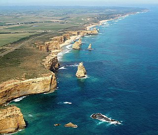
The Twelve Apostles Marine National Park is a protected marine national park located on the south-west coast of Victoria, Australia. The 7,500-hectare (19,000-acre) marine park is situated near Port Campbell and is named after the scenic Twelve Apostles rock stacks, and contains the wreck of the clipper Loch Ard, wrecked on Mutton Bird Island in 1878. The marine park borders Port Campbell and Great Otway National Parks.
The Discovery Bay Marine National Park is a protected marine national park located in the Western District of Victoria, Australia The 2,770-hectare (6,800-acre) marine park is located near Portland, and extends along 6 kilometres (3.7 mi) of coastline on the western side of Cape Bridgewater, from Cape Duquesne to Blacks Beach, and offshore 3 nautical miles to the limit of Victorian waters.

The Bunurong Marine and Coastal Park collectively are a marine park and a coastal park located along the reef and coast of Harmers Haven, Cape Paterson and Inverloch in the South Gippsland region of Victoria, Australia. Collectively, the parks are located approximately 140 kilometres (87 mi) southeast of Melbourne, between Coal Point in the west to Wreck Creek in the east, and are used for walking, picnicking, boating, education and research.
The Gippsland Lakes Coastal Park is a coastal park in the East Gippsland region of Victoria, Australia. The park is located approximately 240 km (150 mi) east of the capital city of Melbourne.

