Androscoggin Swinging Bridge

Last updated
Androscoggin Swinging Bridge
Swinging Bridge Topsham, Maine.jpg
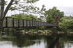
Androscoggin Swinging Bridge c. 2017
Coordinates 43°55′6″N69°58′26″W / 43.91833°N 69.97389°W / 43.91833; -69.97389 Coordinates: 43°55′6″N69°58′26″W / 43.91833°N 69.97389°W / 43.91833; -69.97389
Carries Pedestrians
Crosses Androscoggin River
Locale
Heritage status National Register of Historic Places 14 January 2004
Preceded byThe Black Bridge
Followed by Frank J. Wood Bridge
Characteristics
Design Suspension bridge
Material Wire rope, Steel, Concrete & Wood
Width6 feet (1.8 m)
Longest span322 feet (98 m)
No. of spans1
History
Constructed by John A. Roebling's Sons
Built1892 (1892)
Construction cost US$2,000
Rebuilt
  • 1913 (1913)-1916 (1916) (Towers)
  • 1938 (Deck and railings)
  • 2006 (Overhaul)
Statistics
Androscoggin Swinging Bridge
NRHP reference No. 03001404
Added to NRHPJanuary 2004
Location
Androscoggin Swinging Bridge
References
National Register of Historic Places [1]

The Androscoggin Swinging Bridge (also known simply as the Swinging Bridge) is a pedestrian suspension bridge spanning the Androscoggin River in Maine between the towns of Topsham in Sagadahoc County and Brunswick in Cumberland County. The bridge was built in 1892 as a timesaving approach for employees of the Cabot Manufacturing Company of Brunswick, could have safer and easier passage across the river.

Contents

Design

Built in 1892, the Androscoggin Swinging Bridge has two steel A-frame towers, each 30 feet 6 inches (9.30 m) in height, mounted on concrete abutments. Wire ropes are suspended from the tower, supporting a wooden plank deck suspended from the cables by metal rods, and railings 3 feet 6 inches (1.07 m) high. The span across the river between the towers is 332 feet (101 m), and the distance between the cable anchor points is 520 feet (160 m). The cable is 1.875 inches (4.76 cm) in diameter, with seven wires each composed of seven strands. [2]

History

19th century

The Androscoggin Swinging Bridge was built in 1892 to accommodate cotton mill employees living at Topsham Heights in Topsham, Maine, a new housing development built in the late 19th century. [3] Topsham Heights was a neighborhood that was inhabited by a large Franco-American population recruited from Canada to work in the mills. The bridge has helped thousands of people walk to and from the Cabot Manufacturing Company cotton mill building located on the other side of the river in Brunswick. [4] [5]

In 1891 the Topsham Land Company decided that a footbridge spanning across the Androscoggin River would be a safer, more direct route than the Free Bridge (as it was called then), as it was not conducive to pedestrian traffic. [4] The company hired John A. Roebling's Sons Company, [4] the engineering firm that designed the Brooklyn Bridge in New York City, as well as many other bridges around the world. [6] Construction began on the bridge May 19, 1892, and was completed in September of that year, at a cost of US$ 2,000. In 1906, both towns of Brunswick and Topsham became responsible for the repairs of the bridge. [4]

20th century

Between 1913 and 1916, the bridge's timber-framed towers were replaced with steel by Meguire & Jones, a steel metal fabrication company in South Portland. [4]

At 5:00am on March 20, 1936, a freshet destroyed the superstructure of the bridge. Ice and logs from the Androscoggin River crashed up alongside the bridge isolating Topsham from Brunswick. Both the steel towers and suspension cables survived the flood. The federal Works Progress Administration (WPA) replaced the damaged span and filled in the towers with concrete in 1938. [7] [4]

21st century

c. 2006 Androscoggin Swinging Bridge commemorative plaque.jpg
c. 2006

In 2000, a study performed by both towns found the bridge damaged in many locations including the concrete abutments, the wood planks and rust on all the metal. In 2006 Brunswick and Topsham appointed a committee of residents from both towns who secured funding from the Maine Department of Transportation as well as corporate grants to reconstruct the bridge. In 2007, public parks opened on both sides of the bridge. Two of John A. Roebling’s great-great-great granddaughters spoke at the dedication ceremony on September 8, 2007. [4]

In January of 2004, the Androscoggin Swinging Bridge was listed in the National Register of Historic Places. In May 2011, the bridge was dedicated as a Maine Historic Civil Engineering Landmark by the Maine Section of the American Society of Civil Engineers. The Society paid for the installation of a commemorative plaque. [4] [1]

See also

Related Research Articles

<span class="mw-page-title-main">Suspension bridge</span> Type of bridge

A suspension bridge is a type of bridge in which the deck is hung below suspension cables on vertical suspenders. The first modern examples of this type of bridge were built in the early 1800s. Simple suspension bridges, which lack vertical suspenders, have a long history in many mountainous parts of the world.

<span class="mw-page-title-main">John A. Roebling</span> German-American engineer

John Augustus Roebling was a German-born American civil engineer. He designed and built wire rope suspension bridges, in particular the Brooklyn Bridge, which has been designated as a National Historic Landmark and a National Historic Civil Engineering Landmark.

<span class="mw-page-title-main">Brunswick, Maine</span> Town in Maine, United States

Brunswick is a town in Cumberland County, Maine, United States. The population was 21,756 at the 2020 United States Census. Part of the Portland-South Portland-Biddeford metropolitan area, Brunswick is home to Bowdoin College, the Bowdoin International Music Festival, the Bowdoin College Museum of Art, the Peary-MacMillan Arctic Museum, and the Maine State Music Theatre. It was formerly home to the U.S. Naval Air Station Brunswick, which was permanently closed on May 31, 2011, and has since been partially released to redevelopment as "Brunswick Landing".

<span class="mw-page-title-main">John A. Roebling Suspension Bridge</span> Suspension bridge spanning the Ohio river at Cincinnati opened in 1866

The John A. Roebling Suspension Bridge, originally known as the Cincinnati-Covington Bridge, spans the Ohio River between Cincinnati, Ohio, and Covington, Kentucky. When opened on December 1, 1866, it was the longest suspension bridge in the world at 1,057 feet (322 m) main span, which was later overtaken by John A. Roebling's most famous design of the 1883 Brooklyn Bridge at 1,595.5 feet (486.3 m). Pedestrians use the bridge to get between the hotels, bars, restaurants, and parking lots in Northern Kentucky. The bar and restaurant district at the foot of the bridge on the Kentucky side is known as Roebling Point.

<span class="mw-page-title-main">Starr Mill Road Bridge</span> United States historic place

The Starr Mill Road Bridge is a historic bridge in Middletown, Connecticut. It is a single span Warren through truss bridge, spanning the Coginchaug River near the Starr Mill complex on the west bank of the river. Built in 1927 by the Berlin Construction Company, it is one of a shrinking number of period metal truss bridges in the state. The bridge was listed on the National Register of Historic Places in 1993. It is closed to all forms of passage.

<span class="mw-page-title-main">Pejepscot Paper Company</span>

The Pejepscot Paper Company mill building is a historic paper mill located off U.S. 201 in Topsham, Maine, on the banks of the Androscoggin River, adjacent from Brunswick Falls and the Frank J. Wood Bridge. Built in 1868, the building is one of the oldest surviving paper mills in the state of Maine. The mill was added to the National Register of Historic Places on September 17, 1974, and is now a mixed-use commercial property, housing the Sea Dog Brewing Company.

<span class="mw-page-title-main">Watson Settlement Bridge</span> United States historic place

Watson Settlement Bridge was an historic covered bridge in eastern Littleton, Maine, United States. Built in 1911, it was one of the youngest of Maine's few surviving covered bridges. It formerly carried Framingham Road over the Meduxnekeag River, but was closed to traffic, the road passing over a modern bridge to its south. It was listed on the National Register of Historic Places in 1970. It was destroyed by fire on July 19, 2021.

<span class="mw-page-title-main">Clinton Falls Bridge</span> Bridge in Minnesota, US

The Clinton Falls Bridge, also known as the Old Mill Bridge and formally as Bridge L-5573, is a historic steel Pratt through truss bridge that spans the Straight River in Clinton Falls Township, Minnesota. It was listed on the National Register of Historic Places in 1997 as Bridge No. L-5573 for having local significance in the theme of engineering. It was nominated for being an example of early steel truss bridge design in Minnesota.

<span class="mw-page-title-main">Duck Run Cable Suspension Bridge</span> United States historic place

Duck Run Cable Suspension Bridge, also known as Trubada Swinging Bridge, is a historic cable suspension bridge that spans the Little Kanawha River at Trubada, Gilmer County, West Virginia. The bridge was built in 1922. The bridge is 351 feet, 7 inches, with a main span of 209 feet, 9 inches, and two half spans of 76 feet, 6 inches, and 65 feet, 4 inches. It features four reinforced concrete towers for the two wire rope cables.

<span class="mw-page-title-main">Market Street Bridge (Ohio River)</span> Bridge over the Ohio River near Steubenville, Ohio, United States

The Market Street Bridge is a suspension bridge connecting Market Street in Steubenville, Ohio and West Virginia Route 2 in Follansbee, West Virginia over the Ohio River. As a project of the Steubenville Bridge Company, it was constructed in 1905 by the Ohio Steel Erection Company, the framework was created by the Penn Bridge Company, and the original steel was done by Jones and Laughlin Steel Company and Bethlehem Steel. The bridge spans a length of 1,794 feet (547 m) with a width of 20.7 feet (6.3 m). As of 2002, the average daily traffic was estimated around 15,000 vehicles. It was listed on the National Register of Historic Places in 2019.

<span class="mw-page-title-main">Gilsum Stone Arch Bridge</span> United States historic place

The Gilsum Stone Arch Bridge carries Surry Road over the Ashuelot River in Gilsum, New Hampshire. Built in 1862–63, it is one of the highest stone arch bridges in the state. It has a span of 47 feet 8 inches (14.53 m), and an average height over the river of 36 feet 6 inches (11.13 m). The roadway is 43 feet 6 inches (13.26 m) above the riverbed. It stands on the site of four previous bridges, where the river passes through a deep gorge. The previous bridge was also a stone arch bridge, which was built in 1860 and collapsed a few months later. It was designed by William Leonard Kingsbury, a local official; its builders are not known because the town's records were destroyed in a fire. The present bridge's vault is carefully constructed from dry-laid granite voussoirs that were shaped for a very precise fit, with larger stones at the lower ends of the arch, and a smaller ones at the crown. Some of the stones were left with rough surfaces, while others were hammered smooth.

<span class="mw-page-title-main">Topsham, Maine</span> Town in the state of Maine, United States

Topsham is a town in Sagadahoc County, Maine, United States. The population was 9,560 at the 2020 census. It is part of the Portland–South Portland–Biddeford, Maine metropolitan statistical area. The town is home to the annual Topsham Fair.

<span class="mw-page-title-main">Haggard Ford Swinging Bridge</span> United States historic place

The Haggard Ford Swinging Bridge is a historic suspension bridge in Boone County, Arkansas. It is located adjacent to Cottonwood Road, about 8 miles (13 km) north of Harrison, and spans Bear Creek. It has cast-in-place concrete abutments, towers, and anchorages, and is supported by steel cables. A wooden deck, one travel lane in width, is suspended from steel hangers. The bridge is about 160 feet (49 m) long. The bridge was built 1938–41 with funding from the Works Progress Administration. Fill surrounding the abutments was washed away in 1945 and subsequently replaced. The bridge deck was replaced in 1977.

<span class="mw-page-title-main">New Portland Wire Bridge</span> United States historic place

The New Portland Wire Bridge is a historic suspension bridge in New Portland, Maine. The bridge carries Wire Bridge Road across the Carrabassett River a short way north of the village center. Built in the mid-19th century, it is one of four 19th-century suspension bridges in the state. It is one lane wide, and has a weight limit of 3 tons. The bridge was listed on the National Register of Historic Places in 1970 and was designated as a Maine Historic Civil Engineering Landmark by the American Society of Civil Engineers in 1990.

<span class="mw-page-title-main">Verde River Sheep Bridge</span> United States historic place

The Verde River Sheep Bridge, also known as the Red Point Sheep Bridge, is a suspension bridge which crosses the Verde River in Arizona. Constructed primarily to allow sheep to be driven between grazing ranges on either side of the river. Building started in 1943 and was completed in 1944. Sheep drives stopped in 1978. The bridge was closed in 1987 and largely demolished in 1988. A replica bridge was constructed in by the U.S. Forest Service in 1989 to allow hikers access to the Mazatzal Wilderness in Tonto National Forest. The original west suspension tower still remains alongside the replica bridge.

<span class="mw-page-title-main">Gould's Mill Bridge</span> United States historic place

The Gould's Mill Bridge is a historic Baltimore through truss bridge, carrying Paddock Street across the Black River in Springfield, Vermont. The bridge was built by the Boston Bridge Works Company in 1929 after major flooding in 1927, and is one of the state's few examples of a Baltimore truss. It was listed on the National Register of Historic Places in 2006.

<span class="mw-page-title-main">Grist Mill Bridge, Dam and Mill Site</span> Archaeological site in Michigan, United States

The Grist Mill Bridge, Dam and Mill Site consists of three structures located along Upton Road between Island Road and the Maple River, one-half mile west of Elsie, Michigan in Duplain Township. The three structures are:

<span class="mw-page-title-main">Frank J. Wood Bridge</span> Road bridge in Maine, US

The Frank J. Wood Bridge is a three span, through truss bridge crossing over the Androscoggin River between the towns of Topsham and Brunswick Maine, on Route 201. Opened in 1932, the bridge was originally called the Brunswick-Topsham bridge but was officially renamed the Frank J. Wood Bridge, after a local farmer who suggested the location.

<span class="mw-page-title-main">Fort Andross</span> Site of colonial forts & cotton mills, Brunswick Maine

Fort Andross was a historic trading post and garrison built by the colonial British Empire to fortify against the Wabanaki Native Americans who were aligned with France during King William's War. It was adjacent to Brunswick Falls on the Androscoggin River in Brunswick, Maine. In the 19th century, the location of the fort has been used for several cotton mills including the Cabot Manufacturing Company. In 1986, The mills were transformed into office and retail space and named The Fort Andross Mill Complex.

<span class="mw-page-title-main">Brunswick Falls</span> Dam and waterfall in Brunswick and Topsham, Maine

Brunswick Falls is an ancient section of the Androscoggin River, bordering the towns of Brunswick and Topsham, Maine. First occupied by Paleoindians and the Wabanaki Native Americans, the falls were a plentiful resource for food and trade. Throughout Colonial history, the Industrial Revolution, and into the 21st century, the falls have been a vital part of Brunswick and Topsham's economy, harnessing its power for energy development.

References

  1. 1 2 "National Register Information System  (#03001404)". National Register of Historic Places . National Park Service. July 9, 2010.
  2. "NRHP nomination for Androscoggin Swinging Bridge". National Park Service . Retrieved 5 October 2022.
  3. "Topsham Comprehensive Plan Update 2019" (PDF). maine.org. p. 15. Retrieved 6 October 2022.
  4. 1 2 3 4 5 6 7 8 "Historic Roebling bridge weathers the ages". saveourbridge.org. Retrieved 5 October 2022.
  5. "Bridging the Androscoggin". Bethel Historical Society . Retrieved 6 October 2022.
  6. "John Roebling". National Park Service. 21 June 2020. Retrieved 5 October 2022.
  7. "Bridge Approach Falls and Isolates Topsham". Evening Express (Portland, Maine). 20 March 1936. p. 10. Retrieved 5 October 2022 via newspapers.com.