Cumberland County, Maine

Last updated

Cumberland County
Portland-Head-Lighthouse.jpg
Cumberlandcountyseal.JPG
Map of Maine highlighting Cumberland County.svg
Location within the U.S. state of Maine
Maine in United States.svg
Maine's location within the U.S.
Coordinates: 43°47′04″N70°19′41″W / 43.784477°N 70.32798°W / 43.784477; -70.32798
CountryFlag of the United States.svg United States
StateFlag of Maine.svg  Maine
FoundedNovember 1, 1760
Named for Prince William, Duke of Cumberland
Seat Portland
Largest cityPortland
Area
  Total1,217 sq mi (3,150 km2)
  Land835 sq mi (2,160 km2)
  Water383 sq mi (990 km2)  31%
Population
 (2020)
  Total303,069
  Estimate 
(2021)
305,231 Increase2.svg
  Density250/sq mi (96/km2)
Time zone UTC−5 (Eastern)
  Summer (DST) UTC−4 (EDT)
Congressional district 1st
Website www.cumberlandcounty.org

Cumberland County is a county in the U.S. state of Maine. As of the 2020 census, the population was 303,069, [1] making it the most populous county in Maine. Its county seat is Portland. [2] Cumberland County was founded in 1760 from a portion of York County, Province of Massachusetts Bay, and named for William, Duke of Cumberland, a son of King George II. [3] Cumberland County has the deepest and second-largest body of water in the state, Sebago Lake, which supplies tap water to most of the county. The county is the state's economic and industrial center, having the resources of the Port of Portland, the Maine Mall, and having corporate headquarters of major companies such as Fairchild Semiconductor, IDEXX Laboratories, Unum, and TD Bank. Cumberland County is part of the Portland–South Portland, ME Metropolitan Statistical Area.

Contents

Geography

According to the U.S. Census Bureau, the county has a total area of 1,217 square miles (3,150 km2), of which 835 square miles (2,160 km2) is land and 382 square miles (990 km2) (31%) is water. [4]

Adjacent counties

Major highways

National protected area

Demographics

Historical population
CensusPop.Note
1790 25,530
1800 38,20849.7%
1810 42,83112.1%
1820 49,44515.4%
1830 60,10221.6%
1840 68,65814.2%
1850 79,53815.8%
1860 75,591−5.0%
1870 82,0218.5%
1880 86,3595.3%
1890 90,9495.3%
1900 100,68910.7%
1910 112,01411.2%
1920 124,37611.0%
1930 134,6458.3%
1940 146,0008.4%
1950 169,20115.9%
1960 182,7518.0%
1970 192,5285.3%
1980 215,78912.1%
1990 243,13512.7%
2000 265,6129.2%
2010 281,6746.0%
2020 303,0697.6%
2023 (est.)310,230 [5] 2.4%
U.S. Decennial Census [6]
1790–1960 [7] 1900–1990 [8]
1990–2000 [9] 2010–2019 [10]

2000 census

As of the 2000 census, there were 265,612 people, 107,989 households, and 67,709 families living in the county. The population density was 318 inhabitants per square mile (123/km2). There were 122,600 housing units at an average density of 147 per square mile (57/km2). The racial makeup of the county was 95.74% White, 1.06% Black or African American, 0.29% Native American, 1.40% Asian, 0.04% Pacific Islander, 0.35% from other races, and 1.13% from two or more races. 0.95% of the population were Hispanic or Latino of any race.

There were 107,989 households, out of which 30.10% had children under the age of 18 living with them, 50.10% were married couples living together, 9.50% had a female householder with no husband present, and 37.30% were non-families. 28.40% of all households were made up of individuals, and 10.20% had someone living alone who was 65 years of age or older. The average household size was 2.38 and the average family size was 2.95.

In the county, the population was spread out, with 23.30% under the age of 18, 8.40% from 18 to 24, 31.30% from 25 to 44, 23.60% from 45 to 64, and 13.30% who were 65 years of age or older. The median age was 38 years. For every 100 females, there were 93.80 males. For every 100 females age 18 and over, there were 90.20 males.

The median income for a household in the county was $44,048, and the median income for a family was $54,485. Males had a median income of $35,850 versus $27,935 for females. The per capita income for the county was $23,949. About 5.20% of families and 7.90% of the population were below the poverty line, including 9.10% of those under age 18 and 7.40% of those age 65 or over.

19.6% were of English, 15.5% Irish, 9.6% French, 7.8% United States or American, 7.7% Italian, 6.3% French Canadian and 5.9% German ancestry according to Census 2000. 94.4% spoke English and 2.1% French as their first language.

2010 census

As of the 2010 United States Census, there were 281,674 people, 117,339 households, and 70,778 families living in the county. [11] The population density was 337.2 inhabitants per square mile (130.2/km2). There were 138,657 housing units at an average density of 166.0 per square mile (64.1/km2). [12] The racial makeup of the county was 92.8% white, 2.4% black or African American, 2.0% Asian, 0.3% American Indian, 0.6% from other races, and 1.8% from two or more races. Those of Hispanic or Latino origin made up 1.8% of the population. [11] In terms of ancestry, 22.7% were English, 21.1% were Irish, 9.0% were German, 8.4% were Italian, 6.0% were Scottish, 5.5% were French Canadian, and 4.4% were American. [13]

Of the 117,339 households, 28.3% had children under the age of 18 living with them, 46.8% were married couples living together, 9.7% had a female householder with no husband present, 39.7% were non-families, and 29.7% of all households were made up of individuals. The average household size was 2.32 and the average family size was 2.90. The median age was 41.0 years. [11]

The median income for a household in the county was $55,658 and the median income for a family was $71,335. Males had a median income of $48,158 versus $38,539 for females. The per capita income for the county was $31,041. About 6.9% of families and 10.5% of the population were below the poverty line, including 14.4% of those under age 18 and 7.5% of those age 65 or over. [14]

Government

Cumberland County courthouse in Portland, the county seat Cumberland County Courthouse 5.JPG
Cumberland County courthouse in Portland, the county seat

Cumberland County is represented by county commissioners and the daily operations are run by a county manager. The county has several responsibilities, including running a Sheriff's department, the Cumberland County Jail, and a county court system. Cumberland County also has its own treasury department, emergency management agency and also has a district attorney office. The county also has a stake in the Cross Insurance Arena (formerly called the Cumberland County Civic Center), as well as programs in local economic development and tourism.

Cumberland County is divided into five districts of approximate equal population, each of which elects one county commissioner. The sheriff is elected countywide and runs the Cumberland County Sheriff's office and the Cumberland County Jail.

Politics

Like the rest of Maine, Cumberland County was a solid Republican county after the Civil War. Between 1860 and 1960, the Republican presidential nominee won Cumberland County in every election except 1912, when the county was won by Democrat Woodrow Wilson following a split in the Republican vote between incumbent president William Howard Taft and Progressive nominee, the former Republican president Theodore Roosevelt. The county remained steadfastly and overwhelmingly Republican even in Franklin D. Roosevelt's huge Democratic landslide win in 1936.

In 1964, Democrat Lyndon B. Johnson won Cumberland County and Maine's 15 other counties as part of a 44-state landslide over controversial Republican nominee Barry Goldwater. Cumberland remained in the Democratic column in 1968, backing Hubert H. Humphrey, who had chosen Maine Senator Edmund Muskie as his running mate. These Democratic victories were a sign of things to come for Cumberland County. Though it would snap back into the Republican column for Richard Nixon in 1972, Republican victories in Cumberland grew increasingly narrower, with Republican Gerald Ford winning it by less than 2,000 votes over Democrat Jimmy Carter in 1976. Carter would narrowly win the county in 1980, marking the first time Cumberland had diverged from the rest of Maine in a presidential election, as the state would be carried by Republican nominee Ronald Reagan.

Reagan would easily carry Cumberland in his 49-state landslide re-election in 1984; however, it was Maine's closest county, with Democrat Walter Mondale losing it by a relatively narrow 13.7%. In 1988, George H. W. Bush would become the last Republican, as of 2020, to carry Cumberland County at the presidential level, winning it by less than seven points. In 1992, Democrat Bill Clinton would win the county with nearly 43% of the vote against Bush and independent Ross Perot; it would be the last time a Democrat would receive less than 50% of the vote in Cumberland County in a presidential election. In 2004, Cumberland would become the most Democratic county in Maine, a position it has retained through 2020. In 2008, over 105,000 ballots would be cast for the Democratic candidate, Barack Obama; it would be the first time a candidate received 100,000 votes in Cumberland County in history. Democrats have exceeded 100,000 votes in Cumberland in each subsequent presidential election. In 2020, Democrat Joe Biden won Cumberland County with 66% of the vote, the most lopsided presidential election result in the county since Lyndon Johnson won 69% of the vote in 1964.

In 2012, the county voted 65% to legalize same-sex marriage. [15]

Voter registration

Voter registration and party enrollment as of March 2024 [16]
Democratic 105,469
Unenrolled61,319
Republican 48,741
Green Independent 7,804
No Labels 2,215
Libertarian 826
Total226,374
United States presidential election results for Cumberland County, Maine [17] [18]
Year Republican Democratic Third party
No.%No.%No.%
2020 59,58430.75%128,75966.45%5,4222.80%
2016 57,70933.59%102,98159.94%11,1286.48%
2012 57,82135.30%101,95062.25%4,0152.45%
2008 56,18634.23%105,21864.10%2,7471.67%
2004 65,38440.12%94,84658.20%2,7321.68%
2000 58,54341.05%74,20352.03%9,8746.92%
1996 42,62032.88%69,49653.62%17,49413.50%
1992 45,75232.33%60,78142.95%34,98924.72%
1988 63,02852.93%55,22046.37%8270.69%
1984 65,84256.75%49,89443.00%2900.25%
1980 45,82042.64%47,33744.05%14,30413.31%
1976 48,95949.64%47,00747.66%2,6602.70%
1972 51,26860.59%33,32639.38%230.03%
1968 32,27541.35%44,69757.27%1,0761.38%
1964 22,36530.52%50,84469.39%630.09%
1960 47,27158.49%33,55341.51%10.00%
1956 49,69671.88%19,43828.12%00.00%
1952 46,95769.16%20,83130.68%1100.16%
1948 30,28460.71%18,91337.91%6881.38%
1944 29,34952.15%26,85747.72%720.13%
1940 29,79552.47%26,91147.39%760.13%
1936 30,02155.56%22,89542.37%1,1142.06%
1932 32,86460.82%20,65538.23%5140.95%
1928 33,19067.74%15,64831.94%1580.32%
1924 26,18773.31%7,07819.82%2,4546.87%
1920 24,62369.19%10,48429.46%4781.34%
1916 11,76853.59%9,79544.60%3981.81%
1912 5,15424.95%8,48041.04%7,02734.01%
1908 10,59361.81%5,73533.46%8104.73%
1904 9,35662.15%4,98933.14%7094.71%
1900 8,82458.59%5,77038.31%4663.09%
1896 11,01765.32%5,17530.68%6744.00%
1892 9,16551.85%8,05045.54%4622.61%
1888 9,88053.80%7,97543.43%5082.77%
1884 9,51050.44%8,17043.33%1,1756.23%
1880 10,16750.75%9,33946.62%5282.64%
1876 8,83154.22%7,45645.78%00.00%
1872 7,49162.31%4,53137.69%00.00%
1868 9,13860.18%6,04639.82%00.00%
1864 7,72854.84%6,36545.16%00.00%
1860 7,93459.04%4,81535.83%6905.13%
1856 8,21158.34%5,25837.36%6054.30%
1852 4,47136.19%6,50452.65%1,37911.16%
1848 4,79738.28%5,98947.80%1,74413.92%
1844 4,48339.52%6,16754.36%6956.13%
1840 6,79051.22%6,43848.57%280.21%
1836 3,60842.85%4,81257.15%00.00%

Communities

Cities

Towns

Census-designated places

Other unincorporated communities

Education

School districts include: [19]

Governor Baxter School for the Deaf, a state-owned school, is in the county.

The fictional town of Jerusalem's Lot, featured in the vampire novel 'Salem's Lot by Stephen King, is situated in Cumberland County. King makes passing reference to other nearby towns and cities, including Portland, Falmouth, and Westbrook.

The video game Trauma Team takes place in Cumberland County in the year 2020, referencing Portland and its Back Cove neighborhood. Neither actual hospital housed in Portland is mentioned in-game; instead, a fictional trauma center called Resurgam First Care is fabricated for the plot (in real life, Portland's city motto is "Resurgam", Latin for "I will rise again"). Two other fictional places are mentioned that reference the county name: "Cumberland College" and "Cumberland Institute of Forensic Medicine".

See also

Related Research Articles

<span class="mw-page-title-main">Wheeler County, Oregon</span> County in Oregon, United States

Wheeler County is a county in the U.S. state of Oregon. As of the 2020 census, the population was 1,451, making it Oregon's least populous county. It is named in honor of Henry H. Wheeler. an early settler who owned a farm near Mitchell. The county seat is Fossil, and Wheeler County is known for having Oregon's largest deposit of fossils.

<span class="mw-page-title-main">Polk County, Oregon</span> County in Oregon, United States

Polk County is one of the 36 counties in the U.S. state of Oregon. As of the 2020 census, the population was 87,433. The county seat is Dallas. The county is named for James Knox Polk, the 11th president of the United States.

<span class="mw-page-title-main">York County, Maine</span> County in Maine, United States

York County is the southwesternmost county in the U.S. state of Maine, along the state of New Hampshire's eastern border. It is divided from Strafford County, New Hampshire, by the Salmon Falls River and the connected tidal estuary, the Piscataqua River. York County was permanently established in 1639. Several of Maine's earliest colonial settlements are found in the county, which is the state's oldest and one of the oldest in the United States. As of the 2020 census, its population was 211,972, making it Maine's second-most populous county. Its county seat is Alfred. York County is part of the Portland–South Portland, Maine Metropolitan Statistical Area.

<span class="mw-page-title-main">Oxford County, Maine</span> County in Maine, United States

Oxford County is a county in the state of Maine, United States. As of the 2020 Census, the county had a population of 57,777. Its county seat is the town of Paris. The county was formed on March 4, 1805, by the Massachusetts General Court in the Maine District from northerly portions of York and Cumberland counties. It borders the Canadian province of Quebec. Part of Oxford County is included in the Lewiston-Auburn, Maine metropolitan New England City and Town Area while a different part of Oxford County is included in the Portland-South Portland-Biddeford, Maine metropolitan New England City and Town Area.

<span class="mw-page-title-main">Kennebec County, Maine</span> County in Maine, United States

Kennebec County is a county located in the South-central portion of the U.S. state of Maine. At the 2020 census, the population was 123,642. Its county seat is Augusta, the state capital. The county was established on February 20, 1799, from portions of Cumberland and Lincoln Counties. The name Kennebec comes from the Eastern Abenaki /kínipekʷ/, meaning "large body of still water, large bay."

<span class="mw-page-title-main">Androscoggin County, Maine</span> County in Maine, United States

Androscoggin County is a county in the U.S. state of Maine. As of the 2020 census, the county's population was 111,139. Its county seat is Auburn and its most populous city is Lewiston.

<span class="mw-page-title-main">Cumberland County, Illinois</span> County in Illinois, United States

Cumberland County is a county located in the U.S. state of Illinois. As of the 2020 census, the population was 10,450. Its county seat is Toledo.

<span class="mw-page-title-main">Baldwin, Maine</span> Town in the state of Maine, United States

Baldwin is a town in Cumberland County, Maine, United States. The population was 1,520 at the 2020 census. It is part of the Portland–South Portland–Biddeford, Maine, metropolitan statistical area.

<span class="mw-page-title-main">Cape Elizabeth, Maine</span> Town in the state of Maine, United States

Cape Elizabeth is a town in Cumberland County, Maine, United States. The town is part of the Portland–South Portland–Biddeford, Maine, metropolitan statistical area. As of the 2020 census, Cape Elizabeth had a population of 9,535.

<span class="mw-page-title-main">Casco, Maine</span> Town in the state of Maine, United States

Casco is a town in Cumberland County, Maine, United States. Casco is included in the Lewiston-Auburn, Maine metropolitan New England city and town area. The population was 3,646 at the 2020 census. Casco includes the villages of Casco, South Casco and Cook Mills. The town borders the east shore of Sebago Lake, and is home to part of Sebago Lake State Park. Casco is part of the Portland–South Portland–Biddeford, Maine metropolitan statistical area. Casco is just under 30 miles (48 km) from downtown Portland.

<span class="mw-page-title-main">Falmouth, Maine</span> Town in Maine, United States

Falmouth is a town in Cumberland County, Maine, United States. The population was 12,444 at the 2020 census. It is part of the Portland–South Portland–Biddeford, Maine metropolitan statistical area.

<span class="mw-page-title-main">Harrison, Maine</span> Town in the state of Maine, United States

Harrison is a town in Cumberland County, Maine, United States. Harrison is included in the Lewiston-Auburn, Maine metropolitan New England city and town area. The population was 2,447 at the 2020 census. A historic resort area, Harrison straddles Long Lake and Crystal Lake. It is part of the Portland–South Portland–Biddeford, Maine metropolitan statistical area.

<span class="mw-page-title-main">Long Island, Maine</span> Town in Maine, United States

Long Island is an island town in Cumberland County, Maine, United States, which seceded from the city of Portland in 1993. The population was 234 at the 2020 census. It is part of the Portland–South Portland–Biddeford, Maine Metropolitan Statistical Area.

<span class="mw-page-title-main">Naples, Maine</span> Town in the United States

Naples is a town in Cumberland County, Maine, United States. It is part of the Portland–South Portland–Biddeford, Maine metropolitan statistical area. The population was 3,925 at the 2020 census, and it is home to part of Sebago Lake State Park. Naples is a resort area.

<span class="mw-page-title-main">Raymond, Maine</span> Town in the state of Maine, United States

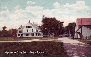
Raymond is a town in Cumberland County, Maine, United States. Raymond is included in the Lewiston-Auburn, Maine metropolitan New England city and town area. The population was 4,536 at the 2020 census. It is a summer recreation area and is part of the Portland–South Portland–Biddeford, Maine metropolitan statistical area. Raymond Neck is the landing for the ferry to the town of Frye Island in Sebago Lake. The Raymond school system is currently affiliated with the Windham school system in a district known as RSU 14.

<span class="mw-page-title-main">Sebago, Maine</span> Town in Maine, United States

Sebago is a town in Cumberland County, Maine, United States. The population was 1,911 at the 2020 census. It is part of the Portland–South Portland–Biddeford, Maine metropolitan statistical area.

<span class="mw-page-title-main">Standish, Maine</span> Town in the state of Maine, United States

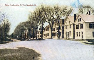
Standish is a town in Cumberland County, Maine, United States. The population was 10,244 at the 2020 census. It includes the villages of Standish Corner, Sebago Lake Village and Steep Falls, and the localities known as Richville, Elmwood, Standish Neck and Two Trails. Standish is part of the Portland-South Portland-Biddeford, Maine metropolitan statistical area.

<span class="mw-page-title-main">Westbrook, Maine</span> City in Maine, United States

Westbrook is a city in Cumberland County, Maine, United States and a suburb of Portland. The population was 20,400 at the 2020 census, making it the fastest-growing city in Maine between 2010 and 2020. It is part of the Portland–South Portland–Biddeford, Maine metropolitan statistical area.

<span class="mw-page-title-main">Portland metropolitan area, Maine</span> Metropolitan area in United States of America

The city of Portland, Maine, is the hub city of a metropolitan area in southern Maine. The region is commonly known as Greater Portland or the Portland metropolitan area. For statistical purposes, the U.S. federal government defines three different representations of the Portland metropolitan area. The Portland–South Portland, Maine, metropolitan statistical area is a region consisting of three counties in Maine, anchored by the city of Portland and the smaller city of South Portland. As of the 2020 census, the MSA had a population of 551,740. A larger combined statistical area (CSA), the Portland–Lewiston–South Portland combined statistical area, is defined as the combination of this metropolitan statistical area (MSA) with the adjacent Lewiston–Auburn MSA. The CSA comprises four counties in southern Maine. The Portland–South Portland metropolitan New England city and town area is defined on the basis of cities and towns rather than entire counties. It consists of most of Cumberland and York counties plus the town of Durham in Androscoggin County. The Greater Portland area has emerged as an important center for the creative economy, which is also bringing gentrification.

<span class="mw-page-title-main">Gorham, Maine</span> Town in the state of Maine, United States

Gorham is a town in Cumberland County, Maine, United States. The population was 18,336 at the 2020 United States Census. In addition to its urban village center known as Gorham Village or simply "the Village," the town encompasses a number of smaller, unincorporated villages and hamlets with distinct historical identities, including South Gorham, West Gorham, Little Falls, White Rock, and North Gorham. Gorham is home to one of the three campuses of the University of Southern Maine. In 2013, Gorham was voted second-best town in Maine after Hampden by a financial website.

References

  1. "Explore Census Data". data.census.gov. Retrieved November 19, 2021.
  2. "Find a County". National Association of Counties. Archived from the original on May 31, 2011. Retrieved June 7, 2011.
  3. "Cumberland County, Maine". Archived from the original on April 27, 2012. Retrieved May 5, 2012.
  4. "2010 Census Gazetteer Files". United States Census Bureau. August 22, 2012. Archived from the original on September 9, 2014. Retrieved September 7, 2014.
  5. "Annual Estimates of the Resident Population for Counties: April 1, 2020 to July 1, 2023". United States Census Bureau. Retrieved April 3, 2024.
  6. "U.S. Decennial Census". United States Census Bureau. Retrieved September 7, 2014.
  7. "Historical Census Browser". University of Virginia Library. Archived from the original on August 11, 2012. Retrieved September 7, 2014.
  8. "Population of Counties by Decennial Census: 1900 to 1990". United States Census Bureau. Retrieved September 7, 2014.
  9. "Census 2000 PHC-T-4. Ranking Tables for Counties: 1990 and 2000" (PDF). United States Census Bureau. Archived (PDF) from the original on March 27, 2010. Retrieved September 7, 2014.
  10. "State & County QuickFacts". United States Census Bureau. Archived from the original on August 5, 2011. Retrieved August 18, 2013.
  11. 1 2 3 "DP-1 Profile of General Population and Housing Characteristics: 2010 Demographic Profile Data". United States Census Bureau. Archived from the original on February 13, 2020. Retrieved January 21, 2016.
  12. "Population, Housing Units, Area, and Density: 2010 - County". United States Census Bureau. Archived from the original on February 13, 2020. Retrieved January 21, 2016.
  13. "DP02 SELECTED SOCIAL CHARACTERISTICS IN THE UNITED STATES – 2006-2010 American Community Survey 5-Year Estimates". United States Census Bureau. Archived from the original on February 13, 2020. Retrieved January 21, 2016.
  14. "DP03 SELECTED ECONOMIC CHARACTERISTICS – 2006-2010 American Community Survey 5-Year Estimates". United States Census Bureau. Archived from the original on February 13, 2020. Retrieved January 21, 2016.
  15. "2016 Election Results: President Live Map by State, Real-Time Voting Updates". Election Hub. November 8, 2016. Retrieved April 6, 2018.
  16. Bureau of Corporations, Elections & Commissions (March 29, 2024). "Registered & Enrolled Voters Statewide" (PDF). Maine SOS. Retrieved April 9, 2024.
  17. Leip, David. "Dave Leip's Atlas of U.S. Presidential Elections". uselectionatlas.org. Retrieved April 6, 2018.
  18. "Our Campaigns - Container Detail Page".
  19. "2020 CENSUS - SCHOOL DISTRICT REFERENCE MAP: Cumberland County, ME" (PDF). U.S. Census Bureau. Archived (PDF) from the original on July 22, 2022. Retrieved July 22, 2022. - Text list

43°49′N70°20′W / 43.81°N 70.33°W / 43.81; -70.33