
Cumberland County is a county in the U.S. state of Maine. As of the 2020 census, the population was 303,069, making it the most populous county in Maine. Its county seat is Portland. Cumberland County was founded in 1760 from a portion of York County, Province of Massachusetts Bay, and named for William, Duke of Cumberland, a son of King George II. Cumberland County has the deepest and second-largest body of water in the state, Sebago Lake, which supplies tap water to most of the county. The county is the state's economic and industrial center, having the resources of the Port of Portland, the Maine Mall, and having corporate headquarters of major companies such as Fairchild Semiconductor, IDEXX Laboratories, Unum, and TD Bank. Cumberland County is part of the Portland–South Portland, ME Metropolitan Statistical Area.

Branford is a shoreline town located on Long Island Sound in New Haven County, Connecticut, about 6 miles (10 km) east of downtown New Haven. The population was 28,273 at the 2020 census.

South Portland is a city in Cumberland County, Maine, United States, and is the fourth-largest city in the state, incorporated in 1898. As of the 2020 census, the city population was 26,498. Known for its working waterfront, South Portland is situated on Portland Harbor and overlooks the skyline of Portland and the islands of Casco Bay. Due to South Portland's close proximity to air, marine, rail, and highway transportation options, the city has become a center for retail and industry in the region.

Wells is a resort town in York County, Maine, United States. Founded in 1643, it is the third-oldest town in Maine. The population was 11,314 at the 2020 census. Wells Beach is a popular summer destination.

Vestal is a town within Broome County in the Southern Tier of New York, United States, and lies between the Susquehanna River and the Pennsylvania border. As of the 2020 census, the population was 29,110.

State College is a home rule municipality in Centre County in the Commonwealth of Pennsylvania. It is a college town, dominated economically and demographically by the presence of the University Park campus of the Pennsylvania State University.

Narragansett is a town in Washington County, Rhode Island, United States. The population was 14,532 at the 2020 census. However, during the summer months the town's population more than doubles to near 34,000. The town of Narragansett occupies a narrow strip of land running along the eastern bank of the Pettaquamscutt River to the shore of Narragansett Bay. It was separated from South Kingstown in 1888 and incorporated as a town in 1901.
Old Orchard Beach is a resort town and census-designated place (CDP) in York County, Maine, United States. The population was 8,960 at the 2020 census. It is part of the Portland−South Portland−Biddeford, Maine Metropolitan Statistical Area.

Kennebunk is a town in York County, Maine, United States. The population was 11,536 at the 2020 census. Kennebunk is home to several beaches, the Rachel Carson National Wildlife Refuge, the 1799 Kennebunk Inn, many historic shipbuilders' homes, the Brick Store Museum and the Nature Conservancy Kennebunk Plains, with 1,500 acres (6 km2) of nature trails and blueberry fields. The municipality includes the constituent villages of Kennebunk Village (Town), the Lower Village, Kennebunk Landing, Bartlett Mills, West Kennebunk, Kennebunk Beach, Lords Point, Coopers Corner Crossing, Sea Roads Crossing, Webahennet Grove, and Vinegarhill, Cheshire Commons, Kennebunk Meadows, and various newer neighborhoods.
Kennebunkport is a resort town in York County, Maine, United States. The population was 3,629 people at the 2020 census. It is part of the Portland–South Portland–Biddeford metropolitan statistical area.
Midland is a town in southern Cabarrus County in the U.S. state of North Carolina. Located in the Charlotte region of North Carolina, Midland is a 30-minute commute to uptown Charlotte. The name of the town is derived from its location approximately halfway between Charlotte and Oakboro on the railroad line. The population was 3,073 at the 2010 census.

Saco Bay is a small curved embayment of the Gulf of Maine on the Atlantic coast of Maine in the United States. The name derives "from a map of the coastline made in 1525 by the Spanish explorer Esteban Gómez. He named the bay Bahio de Saco ."

Interstate 195 (I-195), also known as the Saco Industrial Spur, is a short auxiliary Interstate Highway running 2.41 miles (3.88 km) in eastern York County, Maine. The highway, located entirely in the city of Saco, is a nominally east–west route that provides access to Downtown Saco and the resort town of Old Orchard Beach from Interstate 95. The western terminus of I-195 is at a trumpet interchange with the Maine Turnpike in central Saco. The route has numbered interchanges with Industrial Park Road, U.S. Route 1, and Maine State Route 5 before terminating at an at-grade intersection with SR 5 near the border between Saco and Old Orchard Beach.

Interstate 95 (I-95) in the US state of Maine is a 303-mile-long (488 km) highway running from the New Hampshire state line in Kittery, to the Canadian border in Houlton. It is the only two-digit Interstate Highway in Maine. In 2004, the highway's route between Portland and Gardiner was changed so that it encompasses the entire Maine Turnpike, a toll road running from Kittery to Augusta.
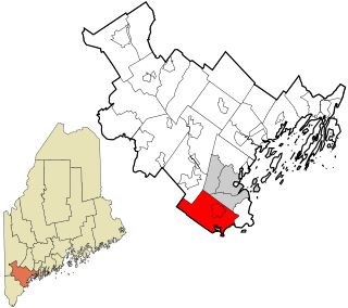
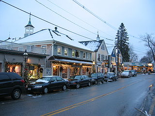
Scarborough is a town in Cumberland County on the southern coast of the U.S. state of Maine. The town is a coastal resort area. Located about 7 miles (11 km) south of Portland, Scarborough is part of the Portland–South Portland–Biddeford, Maine metropolitan statistical area. The population was 22,135 at the 2020 census, making it the most populous town in Maine.

The Spurwink River is a 4.6-mile-long (7.4 km) primarily tidal river in Cumberland County, Maine, in the United States. It rises in the town of Cape Elizabeth and flows west, then southwest, through salt marshes to its mouth at the Atlantic Ocean. It is bridged by Maine State Route 77 at the river's approximate halfway point. From a point shortly above the bridge to the river's mouth, it forms the boundary between Cape Elizabeth to the east and the town of Scarborough to the west. The river's mouth is at the Scarborough village of Higgins Beach.
West Scarborough is an area within the northwesternmost portion of the town of Scarborough, Maine.
Winthrop is a town in Kennebec County, Maine, United States. The population was 6,121 at the 2020 census. Winthrop's population, however, approximately doubles during the summer months as part-year residents return to seasonal camps located on the shores of Winthrop's Lakes and Ponds. A recreational area located among lakes, the town includes the villages of Winthrop and East Winthrop, and is the center of the Winthrop Lakes Region. Winthrop is included in the Augusta, Maine Micropolitan New England City and Town Area.

The Kite Track was an American harness racing track in Old Orchard Beach, Maine.


