Brownville Junction is a census-designated place (CDP) in the town of Brownville, Piscataquis County, Maine, United States. It is west-central part of the town, on the west side of the Pleasant River, a south-flowing tributary of the Piscataquis River and part of the Penobscot River watershed. Maine State Route 11 passes through the community, leading south 3 miles (5 km) to Brownville village and 7 miles (11 km) to Milo, and northeast 31 miles (50 km) to Millinocket.

Etna is an unincorporated community and census-designated place (CDP) in Licking County, Ohio, United States. As of the 2010 census it had a population of 1,215. It lies at an elevation of 1,069 feet (326 m) at the intersection of U.S. Route 40 and State Route 310. It was listed as a census-designated place in 2010.
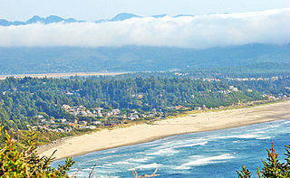
Neahkahnie Beach is a census-designated place and unincorporated community in Tillamook County, Oregon, United States. It is located west of U.S. Route 101, comprising approximately 370 residences north of the city of Manzanita, at the foot of Neahkahnie Mountain. For statistical purposes, the United States Census Bureau has defined Neahkahnie as a census-designated place (CDP). The census definition of the area may not precisely correspond to local understanding of the area with the same name. According to the 2020 Census. the population was 197.
Alfred is a census-designated place (CDP) and the primary village in the town of Alfred, York County, Maine, United States. It is in central York County and the center of the town of Alfred, 4 miles (6 km) northeast of Sanford and 13 miles (21 km) west of Biddeford. U.S. Route 202 passes through the village, leading northeast 23 miles (37 km) to Gorham and southwest through Sanford 20 miles (32 km) to Rochester, New Hampshire. Maine State Route 4 leads south 13 miles (21 km) to North Berwick and leads north out of town with US 202. State Route 111 leads east from Alfred to Biddeford.
Groveland Station is a census-designated place (CDP) in Livingston County, New York, United States. The CDP consists of the hamlet of Groveland and nearby residential areas. The CDP population was 281 as of the 2010 census. New York State Route 63 passes through the community.
Sabattus is a census-designated place (CDP) comprising the primary village in the town of Sabattus, Androscoggin County, Maine, United States. It is situated in the northwestern corner of the town, at the outlet of Sabattus Pond and the start of the Sabattus River, a southward-flowing tributary of the Androscoggin River. Maine State Route 126 forms the southern edge of the CDP; the highway leads west 6 miles (10 km) to the center of Lewiston and northeast 20 miles (32 km) to Gardiner. State Route 9 runs south from Sabattus 9 miles (14 km) to Lisbon Falls and follows Route 126 northeast to Gardiner.
Turner is a census-designated place (CDP) and the primary village in the town of Turner, Androscoggin County, Maine, United States. It is in the center of the town, situated on the Nezinscot River, a northeast-flowing tributary of the Androscoggin River. Maine State Routes 4 and 117 cross just west of the center of the village. Route 4 leads north 17 miles (27 km) to Livermore Falls and south 11 miles (18 km) to Auburn, while Route 117 leads northwest 6 miles (10 km) to Buckfield and northeast 6 miles to Howes Corner in the northern part of the town of Turner.
Island Falls is a census-designated place (CDP) and the primary village in the town of Island Falls, Aroostook County, Maine, United States. It is in the northwest part of the town, situated on the West Branch Mattawamkeag River, part of the Penobscot River watershed. U.S. Route 2 passes through the village, leading northeast 27 miles (43 km) to Houlton and south 38 miles (61 km) to Mattawamkeag. Maine State Route 159 has its eastern terminus at U.S. 2 in the center of Island Falls and leads west 10 miles (16 km) to Patten. Interstate 95 passes just west of the village of Island Falls, with access from Exit 276 ; I-95 leads northeast to Houlton and southwest 92 miles (148 km) to Bangor.
Bethel is a census-designated place (CDP) and the primary village in the town of Bethel, Oxford County, Maine, United States. It is situated in the southwestern part of the town, south of the Androscoggin River. U.S. Route 2 passes through the northwestern side of the CDP, leading northeast 23 miles (37 km) to Rumford and west 22 miles (35 km) to Gorham, New Hampshire. Maine State Route 5 joins Route 2 in Bethel but runs south through the village center and continues southwest 36 miles (58 km) to Fryeburg. State Route 26 leads southeast from Bethel 24 miles (39 km) to South Paris.
Corinna is a census-designated place (CDP) and the primary village in the town of Corinna, Penobscot County, Maine, United States. It is in the southern part of the town, on both sides of the East Branch Sebasticook River, part of the Kennebec River watershed.
Mattawamkeag is a census-designated place (CDP) and the primary village in the town of Mattawamkeag, Penobscot County, Maine, United States. It is in the southwestern corner of the town, where the Mattawamkeag River joins the Penobscot. The community is bordered to the south by the town of Winn and to the west, across the Penobscot, by the town of Woodville.
Patten is a census-designated place (CDP) and the primary village in the town of Patten, Penobscot County, Maine, United States. It is in the northeastern part of the town, mostly on the north side of Fish Stream, an eastward-flowing tributary of the West Branch Mattawamkeag River and part of the Penobscot River watershed.
Milbridge is a census-designated place (CDP) and the primary village in the town of Milbridge, Washington County, Maine, United States. It is in southwestern Washington County, near the center of the town of Milbridge, on the west side of the tidal Narraguagus River. It is bordered to the west by the town of Steuben.
Vanceboro is a census-designated place (CDP) and the primary village in the town of Vanceboro, Washington County, Maine, United States. It is in northeastern Washington County, on the west side of the St. Croix River, which forms the Canada–United States border. Directly across the border is the small community of St. Croix, New Brunswick.
Cornish is a census-designated place (CDP) and the primary village in the town of Cornish, York County, Maine, United States. It is on the northern border of York County, on the south side of the Ossipee River where it joins the Saco. To the north, across the Ossipee, is the town of Hiram in Oxford County, and to the east, across the Saco, is the town of Baldwin in Cumberland County.
Old Town is a census-designated place (CDP) in Luna County, New Mexico, United States. It was first listed as a CDP prior to the 2020 census.
Pownal is an unincorporated community and census-designated place (CDP) in the town of Pownal, Bennington County, Vermont, United States. It was first listed as a CDP prior to the 2020 census.
Bolton is the primary village and a census-designated place (CDP) in the town of Bolton, Chittenden County, Vermont, United States. It was first listed as a CDP prior to the 2020 census.
Middletown Springs is the primary village and a census-designated place (CDP) in the town of Middletown Springs, Rutland County, Vermont, United States. As of the 2020 census, it had a population of 194, out of 794 in the entire town.
Townshend is the primary village and a census-designated place (CDP) in the town of Townshend, Windham County, Vermont, United States. As of the 2020 census, it had a population of 199, compared to 1,291 in the entire town.


