Anglo-Ottoman Convention of 1913

Last updated

Anglo-Ottoman Convention of 1913
Map to show the Limits of Kuwait and Adjacent Country (1913).jpg
Map with red circle and green circle boundaries according to the Anglo-Ottoman Convention of 1913
Signed29 July 1913
PartiesFlag of the Ottoman Empire (1844-1922).svg  Ottoman Empire
Flag of the United Kingdom.svg United Kingdom
DepositaryBritish government
Language English

The Anglo-Ottoman Convention of 1913, also known as the "Blue Line", was an agreement between the Sublime Porte of the Ottoman Empire and the Government of the United Kingdom which defined the limits of Ottoman jurisdiction in the area of the Persian Gulf with respect to Kuwait, Qatar, Bahrain, and the Shatt al-Arab. It was signed on 29 July 1913, but never ratified. The long-lasting impact of the agreement was that of the status of Kuwait; the basis for both formal independence and the frontiers of modern Kuwait were established.

Contents

Background

Informal negotiations began on 29 July 1911 in a British memorandum sent to the Ottoman Government. By this time, it seemed likely that the terminus for the German funded and engineered Baghdad Railway would be situated in Kuwait. [1] Kuwait had been under Ottoman administration since 1871 and in 1875 was included in the Basra Vilayet. Although the sheikhdom now fell under the Empire’s jurisdiction, no Ottoman official was stationed in Kuwait. [2] Influence over Kuwait was crucial to British foreign policy in the Persian Gulf with regard to commerce and strategic interests concerning India.

To the British, further extension of the railway line meant further expansion of Ottoman influence, and the current administration—already emboldened by the “Young Turk” regime—desired to reestablish effective control over its empire south of Kuwait. [3] Even worse was the possible encroachment of other European powers. In the proposed memorandum, the British therefore sought to regularize the 1901 Status Quo agreement, with the added refinement of a clear definition of Kuwait's boundaries to Britain's advantage. [4]

Although at times deadlocked, negotiations communicated via memorandums continued on a quid pro quo basis in which the British had the advantage; if the Ottomans were to accept Kuwait's autonomous status and proposed boundaries, the British would have to accept Ottoman suzerainty, and in return, the northern islands of Warbah and Bubiyan must be allocated to Kuwait, and so forth. [5] The waning influence of Istanbul in the Gulf forced it to make concessions without much to gain in return. The Ottoman Empire had faced a number of setbacks in the last few decades—a few of its provinces achieved independence, some were annexed by other countries, or many lost in conflict—and for internal political reasons it may have seemed important to maintain Kuwait as part of the empire, even if only symbolically. The Ottomans also felt that making this agreement would ensure British support on other more pressing issues, such as dealing with invasion by other European powers and conflicts in other parts of the Ottoman Empire. Furthermore, British pressures led the Ottomans to abandon the proposed extension of the railway line to Kuwait and instead opt for a Basra terminus. [6] Plans for a Basra terminus created a new series of demands on behalf of the British, including the Ottoman renunciation of Qatar, and delineating its role in the wider Persian Gulf waters. Britain had wanted to conclude agreements with Sheikh of Qatar Jasim al-Thani about illicit arms traffic and maritime peace, and also sought to formally establish its dominance in the Gulf. By 6 May 1913 Britain and the Ottoman Empire initialed the compromise and the Anglo-Ottoman Convention was signed on 29 July 1913, exactly two years after the first memorandum.

Non-ratification

The Anglo-Ottoman Convention was only part of a wider bargaining process and the complexities of the competing European commercial interests in the region prevented its ratification. Russia, France, and Germany (and later Italy) also had been pressing the Ottoman government for railway concessions. Ratification was further complicated by the fact that most of the Powers themselves were engaged in bilateral negotiations with the Ottoman Empire, just as the British had done with this Convention. Also, attempts to obtain oil concessions from the Ottoman government added to the complexity of commercial arrangements. Finally, the Ottomans and British emerged as enemies within months of the Anglo-Ottoman Convention of 1913, as the outbreak of World War I diminished any hope left for ratification. [7]

Prior to the outbreak of hostilities a companion agreement covering the rest of the Arabian Peninsula, the Violet Line, was also negotiated.

Terms

I. Kuwait

Section I of the convention comprised ten articles concerning the status of Kuwait, and its territorial boundaries. It included contradictory provisions in that the British acknowledged Kuwait as an autonomous provincial sub-district ( kaza ) of the Ottoman Empire within the drawn green-zone and pledged to not establish a protectorate, while the Ottoman Empire recognized the validity of agreements that had made Kuwait a British protectorate except by name and recognized Kuwait as an independent entity within the drawn red-zone.

According to the agreement, Kuwait constituted “an autonomous kaza of the Ottoman Empire,” thereby recognizing Sheikh Mubarak al-Sabah as ruler of Kuwait as well as kaymakam (Ottoman district governor) (Article 1). Kuwait was listed as such because the Ottomans and British interpretations of “sovereignty” and “suzerainty” differed in their counter-drafts and so both terms were omitted in the final draft. [8]

As it was an “autonomous” kaza, the Ottoman government agreed to refrain from interfering in the affairs of Kuwait, “including the question of succession, and from any administrative as well as any occupation or military act.” It also allowed for the use of the Ottoman flag with the option to inscribe the word “Kuwait” on it (Article 2).

The agreement also identified the territories of Kuwait as two different regions, demarcated in red and green on a map annexed to the convention. The red line, as it is commonly referred to, demarcated the region in which the sheikh was to have “complete administrative autonomy.” This region was formed by “a semicircle with the town of Kuwayt in the center, the Khawr al-Zubayr at the northern extremity and al-Qurrayin at the southern extremity” (Article 5). This also included the surrounding islands of Warba and Bubiyan, which were major bargaining points for the British who viewed the Ottoman military posts on the islands as a threat. [9]

The green line defined the region in which the Sheikh of Kuwait would exercise the administrative rights of an Ottoman kaymakam. The tribes situated in that area were “recognized within the dependence of the Shaykh of Kuwait,” and as kaymakam he was required to collect tribute (Article 6). The importance of the green line is that it set out for the first time the basis for the established frontiers of modern Kuwait: [10]

The demarcation line begins on the coast at the mouth of Khor al-Zubair in the northwest and crosses immediately south of Umm-Qasr, Safwan, and Jabla Sanam, in such a way as to leave to the vilayet of Basrah these locations and their wells; arriving at the al-Batin, it follows it toward the southwest until Hafr-al-Batin which it leaves on the same side as Kuwayt; from that point on the line in question goes southeast leaving to the wells of al-Safah, al-Garaa, al-Haba, al-Warbah, and Antaa, reaching the sea near Jabal Munifa (Article 7).

Another major provision, and one which the Ottomans required, was that of the British declaration that no protectorate would be established over Kuwait (Article 4). Yet, the Ottoman government recognized the validity of the Anglo-Kuwaiti Agreement of 1899, and the 1900 and 1904 agreements in which Kuwait had undertaken not to engage in arms trade or allow another power to establish a post office, as well as land concessions made by the Sheikh to the British government (Article 3).

Smaller provisions were also added at the convention, which included the Sheikh's right to his private property in the vilayet of Basra (Article 9) and extradition (Article 10).

II. Qatar & III. Bahrain

Section II and III constitute provisions for Qatar and Bahrain, respectively. Central to the negotiations was the status of Qatar and Bahrain, and the British pressured the Ottoman government that it should renounce its claims to both. If the Ottoman government retained sovereignty over Qatar and Bahrain that would enable it the right to still intervene in matters of the Gulf, of which the British desired to retain a monopoly. [11]

The Ottomans were willing to drop all claims to Bahrain, in which they had never been able to maintain anything but a symbolic role, but not Qatar. As a question of sovereignty, the Ottomans argued that the empire had always exercised effective sovereignty over the peninsula and could not justify the abandonment of territory which it had never formally renounced. [12] Yet under considerable pressure it renounced claims to both (Articles 11 & 13) [13] and a blue line was established to define the territorial limits of Ottoman jurisdiction. This line separated the Ottoman sanjak of Najd from Qatar. The blue line began a few miles to the south of Zaknuniya (which was included in the sanjak), directly south up to the Rub' al-Khali (Article 11). The agreement did not mention that Zaknuniya would be part of the Najd sanjak in return for an Ottoman consideration of £1,000 paid to the Sheikh of Bahrain via the British government. [14]

With regard to Bahrain, the Ottomans renounced all claims to it so long as the British declared no intention of annexing it (Article 13) and did not claim capitulation rights for subjects of the Sheikh of Bahrain (protected by the Britannic Majesty's Consuls) living in the Ottoman Empire (Article 15).

IV. The Persian Gulf

The final step in ensuring its dominance over the Persian Gulf was formalizing British policing of the Gulf. Therefore, “for the Protection of its special interests…in the free water of the Persian Gulf and on the borders belonging to the independent Shaykhs from the south of al-Qatar up to the Indian Ocean,” the British were able to continue exercising, as in the past, the following measures (Article 16):

(a) Soundings, lighting of lighthouses, placement of buoys, piloting
(b) Maritime police
(c) Quarantine measures

Related Research Articles

Kuwait is a sovereign state in Western Asia located at the head of the Persian Gulf. The geographical region of Kuwait has been occupied by humans since antiquity, particularly due to its strategic location at the head of the Persian Gulf. In the pre-oil era, Kuwait was a maritime port city. In the modern era, Kuwait is best known for the Gulf War (1990–1991).

<span class="mw-page-title-main">History of Qatar</span>

The history of Qatar spans from its first duration of human occupation to its formation as a modern state. Human occupation of Qatar dates back to 50,000 years ago, and Stone Age encampments and tools have been unearthed in the Arabian Peninsula. Mesopotamia was the first civilization to have a presence in the area during the Neolithic period, evidenced by the discovery of potsherds originating from the Ubaid period near coastal encampments.

<span class="mw-page-title-main">Zubarah</span> Ruined Town in Al Shamal, Qatar

Zubarah, also referred to as Al Zubarah or Az Zubarah, is a ruined and ancient fort located on the north western coast of the Qatar peninsula in the Al Shamal municipality, about 65 miles from the Qatari capital of Doha. It was founded by Shaikh Muhammed bin Khalifa, the founder father of Al Khalifa royal family of Bahrain, the main and principal Utub tribe in the first half of the eighteenth century. It was designated a UNESCO World Heritage Site in 2013.

Frank Holmes, known affectionately by Arabs as "Abu Naft", was a British-New Zealand mining engineer, geologist and oil concession hunter. Following distinguished service in World War I, he was granted the title of honorary Major and was thereafter known as Major Frank Holmes in his civilian life.

<i>Kaymakam</i> Title for a district governor in Turkey, Northern Cyprus, Lebanon and the Ottoman Empire

Kaymakam, also known by many other romanizations, was a title used by various officials of the Ottoman Empire, including acting grand viziers, governors of provincial sanjaks, and administrators of district kazas. The title has been retained and is sometimes used without translation for provincial or subdistrict governors in various Ottoman successor states, including the Republic of Turkey, Kuwait, Iraq, and Lebanon.

Ḥakīm and Ḥākim are two Arabic titles derived from the same triliteral root Ḥ-K-M "appoint, choose, judge".

<span class="mw-page-title-main">Mubarak Al-Sabah</span> 7th ruler of the Sheikhdom of Kuwait

Sheikh 
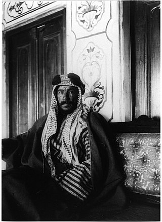
Mubarak Al-Sabah "the Great", nicknamed "The lion of the peninsula", was the seventh ruler of the Sheikhdom of Kuwait, from 18 May 1896 until his death on 18 November 1915. Mubarak ascended the throne upon killing his half-brother, Muhammad Al-Sabah. Known for his significant role in shaping modern Kuwait, the constitution of the State of Kuwait mandates that the Emir of Kuwait must be a descendant of Mubarak from the ruling Al-Sabah family.

<span class="mw-page-title-main">Basra vilayet</span> First-level administrative division of the Ottoman Empire

The Basra Vilayet was a first-level administrative division (vilayet) of the Ottoman Empire. It historically covered an area stretching from Nasiriyah and Amarah in the north to Kuwait in the south. To the south and the west, there was theoretically no border at all, yet no areas beyond Qatar in the south and the Najd Sanjak in the west were later on included in the administrative system.

Persian Gulf Residency Colonial subdivision of the British-Indian Empire

The Persian Gulf Residency was a subdivision of the British Empire from 1822 until 1971, whereby the United Kingdom maintained varying degrees of political and economic control over several states in the Persian Gulf, including what is today known as the United Arab Emirates and at various times southern portions of Iran, Bahrain, Kuwait, Oman, and Qatar.

<span class="mw-page-title-main">Al-Ahsa Oasis</span> Oasis historical region in eastern Saudi Arabia

Al-Aḥsāʾ, also known as al-Ḥasāʾ (الْحَسَاء) or Hajar (هَجَر), is an oasis and historical region in eastern Saudi Arabia. Al-Ahsa Governorate, which makes up much of the country's Eastern Province, is named after it. The oasis is located about 60 km (37 mi) inland from the coast of the Persian Gulf. Al-Ahsa Oasis comprises four main cities and 22 villages. The cities include Al-Mubarraz and Al-Hofuf, two of the largest cities in Saudi Arabia.

<span class="mw-page-title-main">Khawr al Udayd</span> Place in Al Wakrah Municipality, Qatar

Khawr al Udayd, is a settlement and inlet of the Persian Gulf located in Al Wakrah Municipality in southeast Qatar, on the border with Saudi Arabia. It is known to local English speakers as the "Inland Sea". In the past it accommodated a small town and served as the center of a long-running territorial dispute between Sheikh Jassim bin Mohammed Al Thani and Sheikh Zayed bin Khalifa Al Nahyan. At the present, it is a major tourist destination for Qatar.

This article deals with territorial disputes between states of in and around the Persian Gulf in Southwestern Asia. These states include Iran, Iraq, Kuwait, Saudi Arabia, Bahrain, Qatar, the United Arab Emirates (UAE), and Oman.

Sheikh Jassim bin Mohammed Al Thani, also known as "The Founder", was the founder of the State of Qatar. He had a total of 56 children, 19 sons and 37 daughters.

<span class="mw-page-title-main">Sheikhdom of Kuwait</span> Middle Eastern state (1752–1961)

The Sheikhdom of Kuwait was a sheikhdom which gained independence from the Khalidi Emirate of Al Hasa under Sabah I bin Jaber in the year 1752. The Sheikhdom became a British protectorate between 1899 and 1961 following the Anglo-Kuwaiti agreement of 1899. This agreement was made between Sheikh Mubarak Al-Sabah and the British Government in India, primarily as a defensive measure against threats to Kuwait's independence emanating from the Ottoman Empire.

<span class="mw-page-title-main">Najd Sanjak</span> Sanjak of the Ottoman Empire (1871-1915)

The sanjak of Najd was a sanjak of the Ottoman Empire. The name is considered misleading, as it covered the al-Hasa region, rather than the much larger Najd region. It was part of Baghdad Vilayet from June 1871 to 1875, when it became part of the Basra Vilayet.

The Battle of Al Wajbah was an armed conflict that took place in March 1893 in Qatar, a province of the Ottoman Empire's Najd sanjak at that time. The conflict was initiated after Ottoman officials imprisoned 16 Qatari tribal leaders and ordered a column of troops to march toward the Al Thani stronghold in the village of Al Wajbah in response to kaymakam Jassim Al Thani's refusal to come to Ottoman authority.

The Anglo-Kuwaiti Agreement of 1899 was a secret treaty signed between the British Empire and the Sheikhdom of Kuwait on 23 January 1899. Under its provisions Britain pledged to protect the territorial integrity of Kuwait in return for restricting the access of foreign powers to the Sheikhdom and regulating its internal affairs.

<span class="mw-page-title-main">Iraq–Kuwait border</span> International border

The Iraq–Kuwait border is 254 km in length and runs from the tripoint with Saudi Arabia in the west to the Persian Gulf coast in the east.

<span class="mw-page-title-main">Qatar–Saudi Arabia border</span> International border

The Qatar–Saudi Arabia border is 87 km (54 mi) in length and runs from the Gulf of Bahrain coast in the west to the Persian Gulf coast in the east.

<span class="mw-page-title-main">Al-Hasa Expedition (1871)</span> Ottoman military campaign to invade the El-Hasa region

The Al-Hasa Expedition was an Ottoman military campaign to annex the El-Hasa region of eastern Arabia. Ostensibly launched to assist Imam Abdullah bin Faisal in reclaiming control over Najd from his brother Saud bin Faisal, the underlying motive was Medhat Pasha's ambition to extend Ottoman dominion over the Persian Gulf.

References

  1. The original concession granted to the Baghdad Railway Company, dominated by Deutsche Bank, was an extension from Konya to Baghdad.
  2. David H. Finnie, Shifting Lines in the Sand: Kuwait’s Elusive Frontier with Iraq, (Cambridge: Harvard University Press, 1992), 7.
  3. Briton Cooper Busch, Britain and the Persian Gulf, 1894-1914, (Berkeley: University of California Press,1967), 308, and 319.
  4. Finnie, 32.
  5. Busch, 321.
  6. Feroz Ahman, “A Note on the International Status of Kuwait before November 1914,” International Journal of Middle East Studies, Vol. 21, No. 1 (Feb., 1992), 184.
  7. Wilkinson, 61, 66, and 96.
  8. Busch, 337.
  9. Busch, 338; Also, it is important to note that later on Warba and Bubiyan would become very important in the context of the modern history of the Persian Gulf with regard to Saddam Hussein’s 1990 invasion of Kuwait.
  10. Finnie, 35.
  11. Busch, 330.
  12. John C. Wilkinson, Arabia’s Frontiers: The Story of Britain’s Boundary Drawing in the Desert, London: I.B. Taurus & Co Ltd, 1991, 91-92.
  13. Britain had always refused to recognize any Ottoman authority in the Qatar Peninsula outside a de facto presence in Doha. The settlement of tribal groups outside of Doha, notably Zubara, sanctioned by the Ottoman kaymakam and Sheikh of Bahrain, Wasim, was often used as an excuse for British intervention in local affairs. Britain also used the suppression of piracy near the peninsula as an excuse to hold the Ottomans responsible for attacks, and later on as an excuse for domination in the Gulf (Wilkinson, 78-79).
  14. Wilkinson, 63.

Sources

Further reading

Tallon, James N. "Allies and Adversaries: Anglo-Ottoman Boundary Negotiation in the Middle East, 1906–1914" in Justin Q. Olmsted Britain in the Islamic World Imperial and Post-Imperial Connections London: Palgrave, 2019, p.89-105.