
Muker is a village and civil parish at the western end of Swaledale in North Yorkshire, England, within the Yorkshire Dales.

Hawes is a market town and civil parish in North Yorkshire, England, at the head of Wensleydale in the Yorkshire Dales, and historically in the North Riding of Yorkshire. The River Ure north of the town is a tourist attraction in the Yorkshire Dales National Park.

Bishopdale is a dale in the Yorkshire Dales National Park in North Yorkshire, England. The dale is a side dale on the south side of Wensleydale, and extends for some 6 miles (10 km) south west from Aysgarth. Bishopdale is also the name of a civil parish, which includes only the sparsely populated upper reaches of the dale, from the head of the dale as far downstream as Howesyke and Howgill Gill.

Kisdon Force is a series of waterfalls on the River Swale in Swaledale, England. The falls are situated within the Yorkshire Dales National Park in the county of North Yorkshire, 500 metres downstream from the small hamlet of Keld at grid reference NY898010.

Kisdon, also called Kisdon Hill, is a fell situated in upper Swaledale in the Yorkshire Dales National Park in North Yorkshire, England.

Harmby is a village and civil parish in Lower Wensleydale, one mile south-east of Leyburn, in North Yorkshire, England. It is located roughly three miles east of the Yorkshire Dales National Park. Harmby has close links with Spennithorne, a village half a mile to the south-east. The two villages have a joint sports association.

Appersett is a hamlet in the Yorkshire Dales in the Richmondshire district of North Yorkshire, England one mile (1.6 km) west of Hawes. It lies on the A684 road and an unclassified road runs alongside Widdale Beck to connect with the B6255 road between Hawes and Ingleton.

Angram Reservoir is the first of three reservoirs on the River Nidd in Upper Nidderdale, North Yorkshire, England, the others being Scar House Reservoir and finally the compensation reservoir Gouthwaite Reservoir. It is located at OS map reference SE040759. Between them they attract around 150,000 visitors a year.

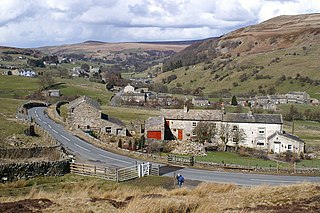
Satron is a hamlet in Swaledale, North Yorkshire, England. It lies 0.6 miles (1 km) south west of Gunnerside on the opposite bank of the River Swale. It is in the civil parish of Muker, but used to be in the ancient parish of Grinton.

Thwaite is a small village in the Yorkshire Dales, North Yorkshire, England. It is in Swaledale and is part the district of Richmondshire and the civil parish of Muker. The village lies on the B6270 road that runs through Swaledale from east to west and is 9.3 miles (15 km) west of Reeth. The name "Thwaite" comes from the Old Norse word þveit, meaning 'clearing, meadow or paddock'.

Braidley is a hamlet in Coverdale in the Yorkshire Dales, England. It lies in the civil parish of Carlton Highdale in the Richmondshire district of North Yorkshire. The River Cover flows nearby, and the peak of Little Whernside is visible from the hamlet.
Arkle Town is a hamlet in Arkengarthdale in the Richmondshire district of North Yorkshire, England. It is situated 0.4 miles (0.64 km) to the south of Langthwaite and 2.7 miles (4.3 km) north-west of Reeth.

Angram Bottoms is a 9.8 hectares biological Site of Special Scientific Interest (SSSI) near to the village of Angram in the Yorkshire Dales, England. The SSSI was first notified in 1989 and is due to the wet and dry grassland habitats which are unusual in the Yorkshire Dales.

Porth Hellick is a tidal inlet on the south coast of St Mary’s, the largest island in the Isles of Scilly.
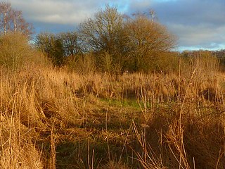
Farnham Mires is a Site of Special Scientific Interest, or SSSI, to the west of the village of Farnham, North Yorkshire, England. It consists of a spring-fed marshy fen or mire with reeds and sedge, and drier calcareous grassland containing a diverse range of flora. It has a history of poaching and fox hunting, but since the late 19th century, the attention of botanists has been drawn to its large variety of flowering plants. It has received some consideration on this account since 1944, and from 1954 it was designated SSSI status. This site has no facilities, and is not open to the public.

Cow Myers is a Site of Special Scientific Interest (SSSI) located in the Nidderdale Area of Outstanding Natural Beauty (AONB), near Ripon, North Yorkshire, England. The site was designated in 1984 for its fen and alder carr habitat, which supports a diversity of wetland plant life. Of particular interest are the bird's eye primrose which is scarce in Yorkshire, and early marsh orchid. There is no public access to this site, no vehicular access, and no public facilities.

Bishop Monkton Ings is a Site of Special Scientific Interest, or SSSI, situated east of Bishop Monkton village in North Yorkshire, England. It consists mostly of marshy, calcareous grassland, with some broadleaved woodland, and some fen alongside the two watercourses which run through the site. This varied wetland forms a habitat for a variety of plants, including the semi-parasitic marsh lousewort (Pedicularis palustris).

Mar Field Fen is a Site of Special Scientific Interest, or SSSI, north of Masham, North Yorkshire, England, in a rural area known as Marfield. It is situated on land containing woodland carr, fen, spring-fed marshy grassland and drier calcareous grassland, between the River Ure to the east and Marfield Wetland nature reserve to the west. As "one of the best examples of fen habitat in the Vale of York," it is a protected habitat for a variety of plants, including the common butterwort, a carnivorous plant. There is no public access to this site.

Crummackdale,, is a small valley north of the village of Austwick in the Craven District of North Yorkshire, England. The Valley is drained by Austwick Beck, which flows into the River Wenning, which in turn heads westwards to empty into the Irish Sea. Crummackdale is a narrow south west facing dale, at the south west corner of the Yorkshire Dales National Park.

