DL postcode area

Last updated

Template:Attached KML/DL postcode area
KML is from Wikidata
Darlington
United Kingdom adm location map.svg
Red pog.svg
DL
Coordinates: 54°31′59″N1°40′08″W / 54.533°N 1.669°W / 54.533; -1.669
CountryUnited Kingdom
Postcode area
DL
Postcode area name
Darlington
Post towns 14
Postcode districts 17
Postcode sectors67
Postcodes (live)13,282
Postcodes (total)16,683
Statistics as at May 2020 [1]

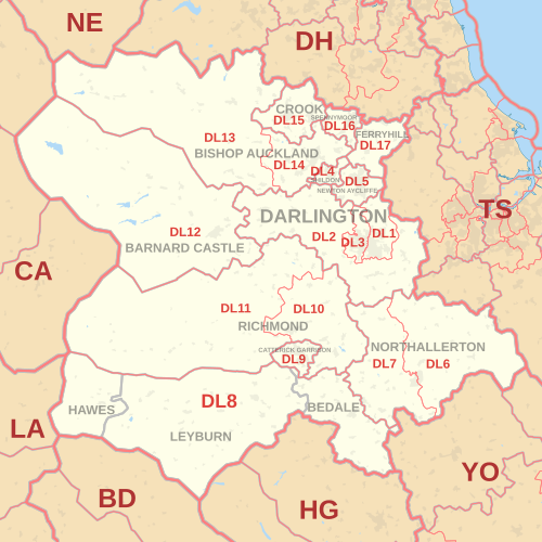
The DL postcode area, also known as the Darlington postcode area, [2] is a group of seventeen postcode districts in England, which are subdivisions of fourteen post towns. These districts cover central County Durham (including Darlington, Bishop Auckland, Ferryhill, Crook, Spennymoor, Shildon, Barnard Castle and Newton Aycliffe), northern North Yorkshire (including Northallerton, Bedale, Hawes, Leyburn, Richmond and Catterick Garrison) and a very small part of Cumbria.

Contents

Coverage

The approximate coverage of the postcode districts:

Postcode district Post town CoverageLocal authority area(s)
DL1DARLINGTON Darlington (east) Darlington
DL2DARLINGTON Staindrop, Gainford, Darlington new estates County Durham, Darlington
DL3DARLINGTONDarlington (west), Faverdale, Coatham Mundeville Darlington
DL4SHILDON Shildon County Durham
DL5NEWTON AYCLIFFE Newton Aycliffe, Heighington County Durham
DL6NORTHALLERTON Northallerton (east), Ingleby Cross North Yorkshire
DL7NORTHALLERTONNorthallerton (west), Romanby, Leeming Bar North Yorkshire
DL8BEDALE Bedale North Yorkshire
HAWES Hawes North Yorkshire
LEYBURN Coverham, Leyburn, Middleham North Yorkshire
DL9CATTERICK GARRISON Catterick Garrison North Yorkshire
DL10RICHMOND Richmond, Catterick, Brompton-upon-Swale, Scotch Corner North Yorkshire
DL11RICHMOND Swaledale, Reeth, Low Row, Arkengarthdale North Yorkshire, Westmorland and Furness
DL12BARNARD CASTLE Barnard Castle, Bowes, Middleton-in-Teesdale County Durham
DL13BISHOP AUCKLAND Stanhope, Frosterley, Wolsingham, Tow Law County Durham, Westmorland and Furness
DL14BISHOP AUCKLAND Bishop Auckland, Evenwood County Durham
DL15CROOK Crook, Willington County Durham
DL16SPENNYMOOR Spennymoor County Durham
DL16FERRYHILL non-geographic [3] [4]
DL17FERRYHILL Ferryhill, Chilton, Cornforth, Bishop Middleham County Durham
DL98DARLINGTONnon-geographic [5]

Map

Template:Attached KML/DL postcode area
KML is from Wikidata
DL postcode area map, showing postcode districts in red and post towns in grey text, with links to nearby BD, CA, DH, HG, LA, NE, TS and YO postcode areas. DL postcode area map.svg
DL postcode area map, showing postcode districts in red and post towns in grey text, with links to nearby BD, CA, DH, HG, LA, NE, TS and YO postcode areas.

See also

Related Research Articles

The TW postcode area, also known as the Twickenham postcode area, is a group of twenty postcode districts in south-east England, within thirteen post towns. These cover parts of south-west London and north-west Surrey, plus a very small part of Berkshire.

The UB postcode area, also known as the Southall postcode area, is a group of eleven postcode districts in England, within six post towns. These cover parts of western and north-western Greater London, plus a very small part of Buckinghamshire. The letters in the postcodes are the phonemic abbreviation of Uxbridge.

The GU postcode area, also known as the Guildford postcode area, is a group of 38 postcode districts in South East England, within 24 post towns. These cover west Surrey, north-east Hampshire, northwestern West Sussex and a small part of south-east Berkshire.

The HP postcode area, also known as the Hemel Hempstead postcode area, is a group of twenty-four postcode districts in England, within eleven post towns. These cover north-west Hertfordshire and central Buckinghamshire.

The NW postcode area, also known as the London NW postcode area, is a group of 13 postcode districts covering around 13,895 live postcodes within part of northwest London, England. It is the successor of the NW sector, originally created as part of the London postal district in 1856.

The SG postcode area, also known as the Stevenage postcode area, is a group of nineteen postcode districts in England, within fifteen post towns. These cover north Hertfordshire and east Bedfordshire, plus a small part of south-west Cambridgeshire and a very small part of Essex.

The BA postcode area, also known as the Bath postcode area, is a group of nineteen postcode districts in South West England, within sixteen post towns. These cover east Somerset and west Wiltshire, plus very small parts of north-west Dorset and south Gloucestershire.

The OL postcode area, also known as the Oldham postcode area, is a group of sixteen postcode districts in north-west England, within seven post towns. These cover eastern Greater Manchester, plus small parts of east Lancashire and western West Yorkshire.

The NR postcode area, also known as the Norwich postcode area, is a group of 35 postcode districts in the east of England, within 16 post towns. These cover central and eastern Norfolk and part of north-east Suffolk.

The WF postcode area, also known as the Wakefield postcode area, is a group of 17 postcode districts in north-east England, which are subdivisions of eleven post towns. These cover much of southern and eastern West Yorkshire, plus small parts of South and North Yorkshire.

The LA postcode area, also known as the Lancaster postcode area, is a group of 23 postcode districts in north-west England, within 17 post towns. These cover north Lancashire and southern Cumbria, and a small part of North Yorkshire.

The SA postcode area, also known as the Swansea postcode area, is a group of 51 postcode districts for post towns Aberaeron, Ammanford, Boncath, Burry Port, Cardigan, Carmarthen, Clynderwen, Crymych, Ferryside, Fishguard, Glogue, Goodwick, Haverfordwest, Kidwelly, Kilgetty, Lampeter, Llanarth, Llandeilo, Llandovery, Llandysul, Llanelli, Llanfyrnach, Llangadog, Llangrannog, Llansaint, Llanwrda, Llanybydder, Milford Haven, Narberth, Neath, New Quay, Newcastle Emlyn, Newport, Pembroke, Pembroke Dock, Pencader, Pontardawe, Port Talbot, Saundersfoot, Swansea, Tenby and Whitland forming south-west Wales.

The TQ postcode area, also known as the Torquay postcode area, is a group of fourteen postcode districts in South West England, within eleven post towns. These cover much of south Devon, including Torquay, Paignton, Newton Abbot, Brixham, Ashburton, Buckfastleigh, Dartmouth, Kingsbridge, Salcombe, South Brent, Teignmouth and Totnes.

The SN postcode area, also known as the Swindon postcode area, is a group of eighteen postcode districts in England, within ten post towns. These cover north Wiltshire, plus a small part of south-west Oxfordshire and a very small part of Gloucestershire.

The BS postcode area, also known as the Bristol postcode area, is a group of 37 postcode districts in South West England, within eight post towns. These cover the city of Bristol, north Somerset and south Gloucestershire.

The GL postcode area, also known as the Gloucester postcode area, is a group of 27 postcode districts in south-west England and a very small part of south-east Wales, within 28 post towns. These cover most of Gloucestershire, including Gloucester, Cheltenham, Stroud, Cirencester, Tewkesbury, Badminton, Berkeley, Blakeney, Chipping Campden, Cinderford, Coleford, Drybrook, Dursley, Dymock, Fairford, Lechlade, Longhope, Lydbrook, Lydney, Mitcheldean, Moreton-in-Marsh, Newent, Newnham, Ruardean, Stonehouse, Tetbury, Westbury-on-Severn and Wotton-under-Edge. The area also covers very small parts of Herefordshire, Worcestershire, Warwickshire, Oxfordshire and Wiltshire, while the GL16 district extends across the Welsh border to cover a very small part of Monmouthshire.

The WR postcode area, also known as the Worcester postcode area, is a group of fifteen postcode districts in England, within seven post towns. These cover central and southern Worcestershire, plus very small parts of Herefordshire, Shropshire, Warwickshire and Gloucestershire.

The WV postcode area, also known as the Wolverhampton postcode area, is a group of sixteen postcode districts in England, within four post towns. These cover Wolverhampton, Willenhall and Bilston in the West Midlands, plus parts of south-west Staffordshire and south-east Shropshire.

The TN postcode area, also known as the Tunbridge Wells postcode area, is a group of 40 postcode districts in England, within 24 post towns. These cover south and west Kent and northern and eastern East Sussex, plus very small parts of Surrey and the London Borough of Bromley.

The L postcode area, also known as the Liverpool postcode area, is a group of postcode districts in North West England. Together they cover central and southern Merseyside, southern West Lancashire, and a small part of north-west Cheshire. Its four post towns are Bootle, Liverpool, Ormskirk, and Prescot.

References

  1. "ONS Postcode Directory Version Notes" (ZIP). National Statistics Postcode Products. Office for National Statistics. May 2020. Table 2. Retrieved 19 June 2020. Coordinates from mean of unit postcode points, "Code-Point Open". OS OpenData. Ordnance Survey. February 2012. Retrieved 21 April 2012.
  2. Royal Mail, Address Management Guide, (2004)
  3. "Non Geographic Codes" (PDF). Royal Mail Address Management Unit. July 2012. Archived from the original (PDF) on 16 September 2012. Retrieved 20 December 2012.
  4. "New sectors and localities to 14 December 2012" (PDF). Royal Mail Address Management Unit. 20 December 2012. Archived from the original (PDF) on 2 February 2015. Retrieved 20 December 2012.
  5. "New sectors and localities to 17 August 2012" (PDF). Royal Mail Address Management Unit. 17 August 2012. Archived from the original (PDF) on 16 September 2012. Retrieved 21 August 2012.