TW postcode area

Last updated

Template:Attached KML/TW postcode area
KML is from Wikidata
Twickenham
United Kingdom adm location map.svg
Red pog.svg
TW
Coordinates: 51°26′49″N0°23′35″W / 51.447°N 0.393°W / 51.447; -0.393
CountryUnited Kingdom
Postcode area
TW
Postcode area name
Twickenham
Post towns 13
Postcode districts 20
Postcode sectors80
Postcodes (live)11,017
Postcodes (total)20,069
Statistics as at May 2020 [1]

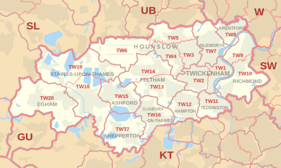
The TW postcode area, also known as the Twickenham postcode area, [2] is a group of twenty postcode districts in south-east England, within thirteen post towns. These cover parts of south-west London and north-west Surrey, plus a very small part of Berkshire.

Contents

Mail for this area is sorted at the Jubilee Mail Centre, Hounslow, [n 1] and the area served includes most of the London Boroughs of Richmond upon Thames and Hounslow, the southernmost part of the London Borough of Hillingdon (including Heathrow Airport) and very small parts of the Royal Borough of Kingston upon Thames. In Surrey it covers virtually all of the borough of Spelthorne, the northern part of the borough of Runnymede and very small parts of the borough of Elmbridge, and in Berkshire it covers the village of Wraysbury in the Royal Borough of Windsor and Maidenhead.

Coverage

The coverage of the postcode districts, naming all localities [n 2]  :

Postcode district Post town CoverageLocal authority area(s)
TW1TWICKENHAM Twickenham, St. Margarets, Strawberry Hill (east) Richmond upon Thames, Hounslow
TW2TWICKENHAM Twickenham (west) [n 3] , Whitton, Strawberry Hill (west), Fulwell (north)Richmond upon Thames
TW3HOUNSLOW Hounslow, Lampton, Whitton (north)Hounslow, Richmond upon Thames
TW4HOUNSLOW Hounslow West, Hounslow Heath, Whitton (west), Cranford (south)Hounslow, Richmond upon Thames
TW5HOUNSLOW Heston, Cranford (north), Osterley (west)Hounslow
TW6HOUNSLOW Heathrow Airport Hillingdon
TW7ISLEWORTH Isleworth, Osterley (east and centre), Whitton (north-east)Hounslow, Richmond upon Thames
TW8BRENTFORD Brentford, Kew Bridge, Syon Park, Brentford Ait Hounslow, Richmond upon Thames [n 4]
TW9RICHMOND Richmond, Kew, North Sheen (north)Richmond upon Thames
TW10RICHMOND Ham, Petersham, Richmond Hill, North Sheen (south), Richmond Park Richmond upon Thames, Kingston upon Thames [n 5]
TW11TEDDINGTON Teddington, Fulwell (east), Bushy Park Richmond upon Thames
TW12HAMPTON Hampton, Hampton Hill, Fulwell (west)Richmond upon Thames
TW13FELTHAM Feltham (south of the railway line), Hanworth Hounslow, Richmond upon Thames
TW14FELTHAM Feltham (north of the railway line), North Feltham, East Bedfont, Hatton Hounslow, Hillingdon, Spelthorne
TW15ASHFORD Ashford Spelthorne, Hounslow
TW16SUNBURY-ON-THAMES Sunbury-on-Thames Spelthorne, Elmbridge [n 6] , Hounslow [n 7] , Richmond upon Thames [n 8]
TW17SHEPPERTON Shepperton, Upper Halliford, Charlton, Littleton Spelthorne, Elmbridge [n 9]
TW18STAINES-UPON-THAMES [5] Staines-upon-Thames, Egham Hythe, Laleham Spelthorne, Runnymede, Windsor and Maidenhead
TW19STAINES-UPON-THAMES [5] Stanwell, Stanwell Moor, Wraysbury, Sunnymeads, Hythe End Spelthorne, Windsor and Maidenhead, Hillingdon
TW20EGHAM Egham, Englefield Green, Thorpe Runnymede

Map

Template:Attached KML/TW postcode area
KML is from Wikidata
TW postcode area map, showing postcode districts in red and post towns in grey text, with links to nearby GU, KT, SL, SW, UB and W postcode areas. TW postcode area map.svg
TW postcode area map, showing postcode districts in red and post towns in grey text, with links to nearby GU, KT, SL, SW, UB and W postcode areas.

See also

Notes and references

Notes
  1. Mail was previously sorted at Rugby Road, Twickenham.
  2. In accordance with WP:UKTOWNS and WP:UKVILLAGES naming settlements with individual articles, excluding sub-neighbourhoods of estates contained in those towns.
  3. Twickenham Green and Heathfield, neighbourhoods of Twickenham, are in TW2.
  4. Brentford Ait, which is uninhabited, is in the London Borough of Richmond upon Thames.
  5. A small part of Ham, in TW10, is in the Royal Borough of Kingston upon Thames.
  6. Large residential island Wheatley's Ait, in TW16, is mostly in Elmbridge.
  7. A café in a layby on the A316 is in the London Borough of Hounslow. [3]
  8. Ten riverside houses in TW16 are in the London Borough of Richmond upon Thames. [4]
  9. Part of residential island Shepperton Lock Island, in TW17, is in Elmbridge.
References
  1. "ONS Postcode Directory Version Notes" (ZIP). National Statistics Postcode Products. Office for National Statistics. May 2020. Table 2. Retrieved 19 June 2020. Coordinates from mean of unit postcode points, "Code-Point Open". OS OpenData. Ordnance Survey. February 2012. Retrieved 21 April 2012.
  2. Royal Mail, Address Management Guide, (2004)
  3. "Food hygiene ratings - Hounslow - Browns Breakfast Bar TW16 5DA". Food Standards Agency . 4 October 2022. Archived from the original on 24 June 2023. Retrieved 24 June 2023.
  4. Spelthorne Planning Map
  5. 1 2 Formerly "STAINES". "New sectors and localities to 20 July 2012" (PDF). Royal Mail Address Management Unit. 20 July 2012. Archived from the original (PDF) on 11 December 2013. Retrieved 18 August 2012.

Related Research Articles

<span class="mw-page-title-main">London Borough of Hounslow</span> London borough in United Kingdom

The London Borough of Hounslow is a London borough in West London, England, forming part of Outer London. It was created in 1965 when three smaller borough councils amalgamated under the London Government Act 1963. It is governed by Hounslow London Borough Council.

<span class="mw-page-title-main">Royal Borough of Kingston upon Thames</span> Royal borough in London, England

The Royal Borough of Kingston upon Thames is a borough in southwest London. The main town is Kingston upon Thames and it includes Surbiton, Chessington, Malden Rushett, New Malden and Tolworth. It is the oldest of the four royal boroughs in England. The others are the London boroughs of Kensington and Chelsea and Greenwich, and Windsor and Maidenhead, the site of Windsor Castle. The local authority is Kingston upon Thames London Borough Council.

<span class="mw-page-title-main">London Borough of Richmond upon Thames</span> Borough in United Kingdom

The London Borough of Richmond upon Thames in southwest London forms part of Outer London and is the only London borough on both sides of the River Thames. It was created in 1965 when three smaller council areas amalgamated under the London Government Act 1963. It is governed by Richmond upon Thames London Borough Council and is divided into nineteen wards. The population is 198,019 and the major settlements are Barnes, East Sheen, Mortlake, Richmond, Twickenham, Teddington and Hampton.

<span class="mw-page-title-main">London postal district</span> Post town

The London postal district is the area in England of 241 square miles (620 km2) to which mail addressed to the London post town is delivered. The General Post Office under the control of the Postmaster General directed Sir Rowland Hill to devise the area in 1856 and throughout its history it has been subject to reorganisation and division into increasingly smaller postal units, with the early loss of two compass points and a minor retraction in 1866. It was integrated by the Post Office into the national postcode system of the United Kingdom during the early 1970s and corresponds to the E, EC, N, NW, SE, SW, W and WC postcode areas. The postal district has also been known as the London postal area. The County of London was much smaller, at 117 square miles (300 km2), but Greater London is much larger at 607 square miles (1,570 km2).

<span class="mw-page-title-main">Middlesex</span> Historic county of England

Middlesex was a historic county in southeast England. Its area was almost entirely within the wider urbanised area of London and mostly within the ceremonial county of Greater London, with small sections in neighbouring ceremonial counties. Three rivers provide most of the county's boundaries; the Thames in the south, the Lea to the east and the Colne to the west. A line of hills forms the northern boundary with Hertfordshire.

<span class="mw-page-title-main">Borough of Spelthorne</span> Place in England

Spelthorne is a local government district and borough in Surrey, England. Its council is based in Staines-upon-Thames; other settlements in the area include Ashford, Sunbury-on-Thames, Shepperton, Stanwell and Laleham.

<span class="mw-page-title-main">Borough of Elmbridge</span> Local government district in Surrey, England

Elmbridge is a local government district with borough status in Surrey, England. Its principal towns and villages are Esher, Cobham, Walton-on-Thames, Weybridge and Molesey. It directly borders the London Borough of Richmond upon Thames and the London Royal Borough of Kingston upon Thames. Some areas of the borough form a continuation of the Greater London Built-up Area, formerly falling into the Metropolitan Police District.

<span class="mw-page-title-main">Sunbury-on-Thames</span> Town in England

Sunbury-on-Thames is a suburban town on the north bank of the River Thames in the Borough of Spelthorne, Surrey, centred 13 mi (21 km) southwest of central London. Historically part of the county of Middlesex, in 1965 Sunbury and other surrounding towns were initially intended to form part of the newly created county of Greater London but were instead transferred to Surrey. Sunbury adjoins Feltham to the north, Hampton to the east, Ashford to the northwest and Shepperton to the southwest. Walton-on-Thames is to the south, on the opposite bank of the Thames.

<span class="mw-page-title-main">Ashford, Surrey</span> Human settlement in England

Ashford is a town in Surrey, England, 14 mi (23 km) west of central London. Its name derives from a crossing point of the River Ash, a distributary of the River Colne. Historically part of Middlesex, the town has been part of Surrey since 1965. Ashford consists of relatively low density low- and medium-rise buildings, none of them being high rise. If excluding apartments most houses are semi-detached.

<span class="mw-page-title-main">Whitton, London</span> Human settlement in England

Whitton is an area of the London Borough of Richmond upon Thames, England. Historically, it was the north-western part of Twickenham manor, bounded by the River Crane and the Duke of Northumberland's River.

The KT postcode area, also known as the Kingston upon Thames postcode area, is a group of 24 postcode districts in England, within 19 post towns. These cover boroughs in south-west Greater London and several boroughs in north-east Surrey.

The CR postcode area, also known as the Croydon postcode area, is a group of eight postcode districts in England, within ten post towns. These cover parts of southern Greater London and north-east Surrey.

The SM postcode area, also known as the Sutton postcode area, is a group of seven postcode districts in England, within five post towns. These cover part of south-west London, as well as a small part of north Surrey.

<span class="mw-page-title-main">Twickenham (UK Parliament constituency)</span> Parliamentary constituency in the United Kingdom, 1918 onwards

Twickenham is a House of Commons constituency in South-West London, represented in the House of Commons of the UK Parliament since 2019 by Munira Wilson of the Liberal Democrats.

<span class="mw-page-title-main">A308 road</span> Road in England

The A308 is a road in England in two parts. The first part runs from Central London to Putney Bridge. The second part runs from just beyond Putney Heath to Bisham, Berkshire. It traces four, roughly straight lines, to stay no more than 3 miles (4.8 km) from the Thames. It is a dual carriageway where it is furthest from that river, in Spelthorne, Surrey and forms one of the motorway spurs to the large town of Maidenhead. Other key settlements served are Fulham, Kingston (London), Staines upon Thames, Windsor and a minor approach to Marlow

The UB postcode area, also known as the Southall postcode area, is a group of eleven postcode districts in England, within six post towns. These cover parts of western and north-western Greater London, plus a very small part of Buckinghamshire. The letters in the postcodes are the phonemic abbreviation of Uxbridge.

<span class="mw-page-title-main">Wheatley's Ait</span>

Wheatley's Ait or Wheatley Eyot is an ait (island) in the River Thames of approximately 8 hectares on the reach above Sunbury Lock, close to the northern side and in the post town Sunbury-on-Thames however in the Borough of Elmbridge in Surrey, England.

The GU postcode area, also known as the Guildford postcode area, is a group of 38 postcode districts in South East England, within 24 post towns. These cover west Surrey, north-east Hampshire, northwestern West Sussex and a small part of south-east Berkshire.

<span class="mw-page-title-main">Spelthorne Hundred</span> Administrative division of England

Spelthorne was a hundred of the historic county of Middlesex, England. It contained these parishes and settlements:

The SW postcode area, also known as the London SW postcode area, is a group of 20 postcode districts within the London post town in England. The area comprises the South Western operational district and the Battersea operational district, and is the only area within the London post town to lie on both sides of the River Thames.