FK postcode area

Last updated

Template:Attached KML/FK postcode area
KML is from Wikidata
Falkirk
United Kingdom adm location map.svg
Red pog.svg
FK
Coordinates: 56°04′41″N3°51′36″W / 56.078°N 3.860°W / 56.078; -3.860
CountryUnited Kingdom
Postcode area
FK
Postcode area name
Falkirk
Post towns 18
Postcode districts 21
Postcode sectors49
Postcodes (live)7,723
Postcodes (total)9,602
Statistics as at May 2020 [1]

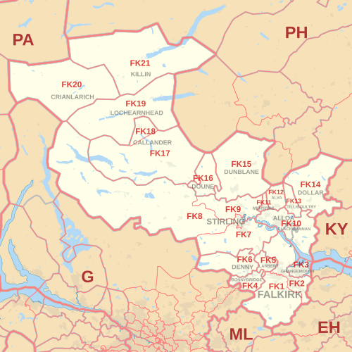
The FK postcode area, also known as the Falkirk postcode area, [2] is a group of 21 postcode districts in central Scotland, within 18 post towns. These cover most of the Falkirk council area (including Falkirk itself, Grangemouth, Larbert, Denny and Bonnybridge), most of the Stirling council area (including Stirling itself, Dunblane, Doune, Callander, Lochearnhead, Crianlarich and Killin) and Clackmannanshire (including Alloa, Clackmannan, Menstrie, Alva, Tillicoultry and Dollar), plus small parts of Fife, Perth and Kinross, and Argyll and Bute.

Contents

Coverage

The approximate coverage of the postcode districts:

Postcode district Post town CoverageLocal authority area(s)
FK1FALKIRK Falkirk (centre and south), Avonbridge, California, Camelon, Limerigg, Shieldhill, Slamannan, Standburn Falkirk
FK2FALKIRKFalkirk (north), Airth, Bainsford, Brightons, Carron, Carronshore, Dunmore, Laurieston, Maddiston, Polmont, Redding, Skinflats, Westquarter Falkirk, Stirling
FK3GRANGEMOUTH Grangemouth, Glensburgh Falkirk
FK4BONNYBRIDGE Bonnybridge, Allandale, Banknock, Dennyloanhead, Greenhill, Haggs, High Bonnybridge, Longcroft Falkirk
FK5LARBERT Larbert, Stenhousemuir, Torwood Falkirk
FK6DENNY Denny, Dunipace, Fankerton, Head of Muir, Stoneywood Falkirk
FK7STIRLING Stirling (south and east), Bannockburn, Cambusbarron, Cowie, Fallin, Plean, South Alloa, St. Ninians Stirling, Falkirk
FK8STIRLINGStirling (centre and west), Aberfoyle, Arnprior, Buchlyvie, Gargunnock, Gartmore, Inversnaid, Kippen, Port of Menteith, Ruskie, Thornhill Stirling
FK9STIRLINGStirling (north), Bridge of Allan, Blair Drummond, Blairlogie, Cambuskenneth, Lecropt Stirling
FK10ALLOA Alloa, Cambus, Kincardine, Sauchie, Tullibody Clackmannanshire, Fife
CLACKMANNAN Clackmannan, Kennet Clackmannanshire
FK11MENSTRIE Menstrie Clackmannanshire
FK12ALVA Alva Clackmannanshire
FK13TILLICOULTRY Tillicoultry, Coalsnaughton, Devonside Clackmannanshire
FK14DOLLAR Dollar, Blairingone, Burnfoot, Glendevon, Pool of Muckhart, Solsgirth Clackmannanshire, Perth and Kinross
FK15DUNBLANE Dunblane, Braco, Greenloaning, Kinbuck Stirling, Perth and Kinross
FK16DOUNE Doune, Argaty, Buchany, Deanston Stirling
FK17CALLANDER Callander, Brig o' Turk, Kilmahog Stirling
FK18CALLANDER Ardchullarie More, Strathyre Stirling
FK19LOCHEARNHEAD Lochearnhead, Ardvorlich, Balquhidder, Edinample, Kingshouse Stirling
FK20CRIANLARICH Crianlarich, Ardchyle, Auchlyne, Luib, Tyndrum Stirling, Argyll and Bute
FK21KILLIN Killin, Ardeonaig, Auchmore, Clachaig, Glenlochay, Kinnell Stirling

Map

Template:Attached KML/FK postcode area
KML is from Wikidata
FK postcode area map, showing postcode districts in red and post towns in grey text, with links to nearby EH, G, KY, ML, PA and PH postcode areas. FK postcode area map.svg
FK postcode area map, showing postcode districts in red and post towns in grey text, with links to nearby EH, G, KY, ML, PA and PH postcode areas.

See also

Related Research Articles

The RM postcode area, also known as the Romford postcode area, is a group of twenty postcode districts in south-east England, within nine post towns. These cover parts of eastern Greater London and south-west Essex. Inward mail for the area is sorted, along with mail for the E and IG postcode areas, at the Romford Mail Centre.

The B postcode area, also known as the Birmingham postcode area, is a group of 79 postcode districts in central England, within 15 post towns. These cover the central portion of the West Midlands, plus northeast Worcestershire, north and west Warwickshire, and part of southeast Staffordshire and a very small part of Leicestershire. It is the most populated postcode area in the United Kingdom, with a population of over 1.9 million.

The LN postcode area, also known as the Lincoln postcode area, is a group of thirteen postcode districts in eastern England, within seven post towns. These cover central Lincolnshire, including Lincoln, Alford, Horncastle, Louth, Mablethorpe, Market Rasen and Woodhall Spa.

The MK postcode area, also known as the Milton Keynes postcode area, is a group of 26 postcode districts in England, within five post towns. These cover north Buckinghamshire, west and north Bedfordshire and very small parts of Northamptonshire, Oxfordshire and Cambridgeshire.

The ML postcode area, also known as the Motherwell postcode area, is a group of twelve postcode districts in south-central Scotland, within twelve post towns. These cover most of North Lanarkshire and South Lanarkshire, plus very small parts of West Lothian, the Scottish Borders and Dumfries and Galloway.

The PE postcode area, also known as the Peterborough postcode area, is a group of 38 postcode districts in eastern England, which are subdivisions of 18 post towns. These cover most of Cambridgeshire, much of south Lincolnshire and west Norfolk, plus parts of east Northamptonshire and very small parts of Bedfordshire and Rutland.

The YO postcode area, also known as the York postcode area, is a group of 29 postcode districts in Yorkshire, England, within ten post towns. These cover most of Central and Eastern North Yorkshire and the northern part of the East Riding of Yorkshire. The rest of North Yorkshire is split between the TS, DL, LA, BD, HG, DN and WF postcode areas.

The WN postcode area, also known as the Wigan postcode area, is a group of eight postcode districts in North West England, within three post towns. These cover most of the Metropolitan Borough of Wigan in Greater Manchester, plus small parts of West Lancashire and the Metropolitan Borough of St Helens in Merseyside.

The LE postcode area, also known as the Leicester postcode area, is a group of 21 postcode districts in central England, within 12 post towns. These cover most of Leicestershire and Rutland, plus small parts of south Nottinghamshire and north Northamptonshire, and very small parts of Derbyshire and Warwickshire.

The NN postcode area, also known as the Northampton postcode area, is a group of nineteen postcode districts in England, within eight post towns. These cover most of Northamptonshire, plus very small parts of Bedfordshire, Buckinghamshire, Leicestershire, Oxfordshire and Warwickshire.

The IP postcode area, also known as the Ipswich postcode area, is a group of 33 postcode districts in the east of England, within 15 post towns. These cover most of Suffolk, plus southern Norfolk and a very small part of Cambridgeshire.

The LS postcode area, also known as the Leeds postcode area, is a group of 29 postcode districts in England, within six post towns. These cover northern West Yorkshire and some parts of North Yorkshire.

The ST postcode area, also known as the Stoke-on-Trent postcode area, is a group of 21 postcode districts in England, within six post towns. These cover much of north and central Staffordshire, plus very small parts of Cheshire and Derbyshire.

The AB postcode area, also known as the Aberdeen postcode area is a group of 33 postcode districts in north-east Scotland, within 24 post towns. These cover the Aberdeen council area, Aberdeenshire and east Moray.

The KY postcode area, also known as the Kirkcaldy postcode area, is a group of sixteen postcode districts in eastern Scotland, within thirteen post towns. These cover most of Fife, plus the far south of Perth and Kinross.

The G postcode area, also known as the Glasgow postcode area, is a group of postcode districts in central Scotland, within five post towns. These districts are primarily centered on Glasgow itself, and West Dunbartonshire, plus parts of the council areas of Argyll and Bute, East Dunbartonshire, North Lanarkshire, South Lanarkshire, East Renfrewshire and Stirling.

The TD postcode area, also known as the Galashiels postcode area, is a group of fifteen postcode districts in south-east Scotland and the far north-east of England, within seventeen post towns. These cover most of the Scottish Borders council area and the northernmost part of Northumberland, plus a part of south-eastern East Lothian and a very small part of Cumberland.

The DG postcode area, also known as the Dumfries and Galloway postcode area, is a group of fifteen postcode districts in south-west Scotland, within fourteen post towns. These cover most of Dumfries and Galloway, including Dumfries, Annan, Canonbie, Castle Douglas, Dalbeattie, Gretna, Kirkcudbright, Langholm, Lockerbie, Moffat, Newton Stewart, Sanquhar, Stranraer and Thornhill. The DG16 district also extends across the border into Cumbria, England.

The HX postcode area, also known as the Halifax postcode area, is a group of seven postcode districts in England, within four post towns. These cover most of the Metropolitan Borough of Calderdale in western West Yorkshire, including Halifax, Elland, Sowerby Bridge and Hebden Bridge.

The HR postcode area, also known as the Hereford postcode area, is a group of nine postcode districts in England and Wales, which are subdivisions of six post towns. These cover most of Herefordshire, including Hereford, Bromyard, Kington, Ledbury, Leominster and Ross-on-Wye, while the HR2, HR3 and HR5 districts extend across the border to cover a small part of Powys.

References

  1. "ONS Postcode Directory Version Notes" (ZIP). National Statistics Postcode Products. Office for National Statistics. May 2020. Table 2. Retrieved 19 June 2020. Coordinates from mean of unit postcode points, "Code-Point Open". OS OpenData. Ordnance Survey. February 2012. Retrieved 21 April 2012.
  2. Royal Mail, Address Management Guide, (2004)