
Central railway station is located on the North Coast line in Queensland, Australia. It is the principal station on the City network and is located in the north of the Brisbane central business district. Central station is one of four inner city stations that form a core corridor through the centre of Brisbane.

Kangaroo Point is an inner southern suburb in the City of Brisbane, Queensland, Australia. In the 2021 census, Kangaroo Point had a population of 9,689 people.

Fortitude Valley is an inner suburb of the City of Brisbane, the state capital of Queensland, Australia. In the 2021 census, Fortitude Valley had a population of 9,708 people. The suburb features two pedestrian malls at Brunswick Street Mall and Chinatown, and is one of the hubs of Brisbane's nightlife, renowned for its nightclubs, bars and adult entertainment.

Coorparoo is a suburb in the inner City of Brisbane, Queensland, Australia. In the 2021 census, Coorparoo had a population of 18,132 people.

Toowong is a riverside suburb in the City of Brisbane, Queensland, Australia. In the 2021 census, Toowong had a population of 12,556 people with a median weekly household income of $1,927.

ANZAC Square is a heritage-listed town square and war memorial located between Ann Street and Adelaide Street, in Brisbane, Queensland, Australia. It is a state memorial to the men and women who participated in overseas armed service and is named in honour of the Australian and New Zealand Army Corps. ANZAC Square is adjacent to ANZAC Square Arcade.

New Farm is an inner northern riverside suburb in the City of Brisbane, Queensland, Australia. In the 2021 census, New Farm had a population of 12,197 people.

The Holy Name Cathedral was a planned but never-built Roman Catholic cathedral for the city of Brisbane, Queensland, Australia. Designed by Hennessy, Hennessy & Co, initially in an English Baroque style inspired by St Paul's in London, it was intended to have been the largest church building of any Christian denomination in the Southern Hemisphere. James Duhig, the Archbishop of Brisbane, was the chief proponent of the project.

Brisbane City is the central suburb and central business district of Brisbane, the state capital of Queensland, Australia. It is colloquially referred to as the "Brisbane CBD" or "the city". It is located on a point on the northern bank of the Brisbane River, historically known as Meanjin, Mianjin or Meeanjin in the local Aboriginal Australian dialect. The triangular shaped area is bounded by the median of the Brisbane River to the east, south and west. The point, known at its tip as Gardens Point, slopes upward to the north-west where the city is bounded by parkland and the inner city suburb of Spring Hill to the north. The CBD is bounded to the north-east by the suburb of Fortitude Valley. To the west the CBD is bounded by Milton, Petrie Terrace, and Kelvin Grove.

Spring Hill is an inner northern suburb in the City of Brisbane, Queensland, Australia. In the 2021 census, Spring Hill had a population of 6,593 people.

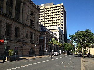
George Street is a major street located in the Brisbane CBD in Brisbane, Queensland, Australia.

Graceville is a suburb in the City of Brisbane, Queensland, Australia. In the 2021 census, Graceville had a population of 4,764 people.

Adelaide Street is a major street in Brisbane, Queensland, Australia. It runs between and parallel to Queen Street and Ann Street.

Edward Street is a busy thoroughfare in the Brisbane central business district, Queensland, Australia. It is a one-way street located between Albert Street and Creek Street, and runs from Upper Edward Street to Alice Street. It is named after Edward VII of the United Kingdom.
William Street is a small, relatively quiet road in the uptown part of the Brisbane central business district. The street is historically significant to the city's early development as a penal colony. The first convict buildings were built along William Street in 1825.

Elizabeth Street is a major street in the centre of the city in Brisbane, Queensland, Australia. The street was one of the earliest in Brisbane being established at the beginning of settlement in Brisbane as Moreton Bay penal settlement. Today, most of the street is fronted by low-level retail outlets, with an increase in mixed use skyscrapers being recently constructed.

Charlotte Street is a road in the central business district of Brisbane, Queensland, Australia. The street is one of a number that were named after female queens and princesses of the royal family shortly after the penal colony was settled. Mary Street runs parallel to the south and Elizabeth Street is the next street to the north.

John H. Buckeridge (1857–1934) was an English-born Australian architect, who built about sixty churches in Queensland and is also remembered for remodelling the interior of the Macquarie era church of St James', King Street, Sydney.
Andrea Giovanni Stombuco (1820-1907) was an Italian-born Australian sculptor and architect. Many of the buildings he designed are listed on the heritage registers in Australia.
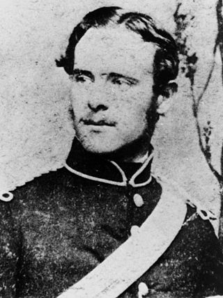
Francis Drummond Greville Stanley (1839–1897) was an architect in Queensland, Australia. He was the Queensland Colonial Architect. Many of his designs are now heritage-listed buildings.


