
Austin is the capital city of the U.S. state of Texas, as well as the seat and largest city of Travis County, with portions extending into Hays and Williamson counties. Incorporated on December 27, 1839, it is the 10th-most-populous city in the United States, the fourth-most-populous city in Texas, and the second-most-populous state capital city. It has been one of the fastest growing large cities in the United States since 2010. Downtown Austin and Downtown San Antonio are approximately 80 miles (129 km) apart, and both fall along the Interstate 35 corridor. Austin is the southernmost state capital in the contiguous United States and is considered a Beta−level global city as categorized by the Globalization and World Cities Research Network.

The Edwards Plateau is a geographic region forming the crossroads of Central, South, and West Texas. It is bounded by the Balcones Fault to the south and east, the Llano Uplift and the Llano Estacado to the north, and the Pecos River and Chihuahuan Desert to the west. San Angelo, Austin, San Antonio, and Del Rio roughly outline the area. The southeast portion of the plateau is known as the Texas Hill Country.

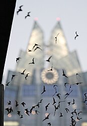
The Austin Ice Bats were a professional minor league ice hockey team based in Austin, Texas, from 1996 to 2008. The were originally members of the Western Professional Hockey League (WPHL) and later the Central Hockey League (CHL). The team was named for the Mexican free-tailed bats that nest under the Ann W. Richards Congress Avenue Bridge in the city.

The Llano River is a tributary of the Colorado River, about 105 miles (169 km) long, in Texas in the United States. It drains part of the Edwards Plateau in Texas Hill Country northwest of Austin.

The Mexican free-tailed bat or Brazilian free-tailed bat is a medium-sized bat native to the Americas, so named because its tail can be almost half its total length and is not attached to its uropatagium. It has been claimed to have the fastest horizontal speed of any animal, reaching top ground speeds over 99 mph (160 km/h). It also flies the highest among bats, at altitudes around 3,300 m (10,800 ft).
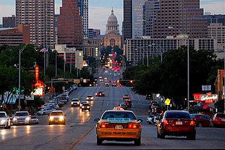
Congress Avenue is a major thoroughfare in Austin, Texas. The street is a six-lane, tree lined avenue that cuts through the middle of the city from far south Austin and goes over Lady Bird Lake leading to the Texas State Capitol in the heart of Downtown.

Merlin Devere Tuttle is an American ecologist, conservationist, writer and wildlife photographer who has specialized in bat ecology, behavior, and conservation. He is credited with protecting the Austin Congress Avenue Bridge bat colony from extermination. Tuttle is currently active as founder and executive director of Merlin Tuttle's Bat Conservation (MTBC) in Austin, Texas.

Bracken Cave is the summer home to the largest colony of bats in the world. An estimated 20 million Mexican free-tailed bats roost in the cave from March to October making it the largest known concentration of mammals. The cave is located in southern Comal County, Texas, outside the city of San Antonio. The 100-foot (30 m)-wide crescent shaped opening to the cave lies at the bottom of a sinkhole, formed when the roof of the cave collapsed.
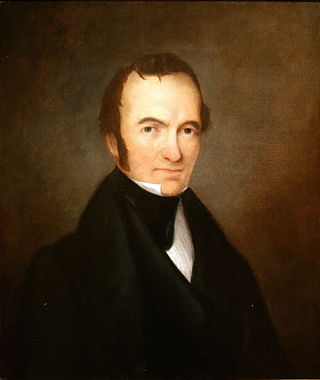
After declaring its independence from Mexico in March, 1836, the Republic of Texas had numerous locations as its seat of government. This being seen as a problem attempts were made to select a permanent site for the capital. January, 1839, with Mirabeau B. Lamar as the newly elected president, a site selection commission of five commissioners was formed. Edward Burleson had surveyed the planned townsite of Waterloo, near the mouth of Shoal Creek on the Colorado River, in 1838; it was incorporated January 1839. By April of that year the site selection commission had selected Waterloo to be the new capital. A bill previously passed by Congress in May, 1838, specified that any site selected as the new capital would be named Austin, after the late Stephen F. Austin; hence Waterloo upon selection as the capital was renamed Austin. The first lots in Austin went on sale August 1839.

The Lamar Boulevard Bridge is a historic arch bridge carrying Texas State Highway Loop 343 over Lady Bird Lake in downtown Austin, Texas, United States. The bridge features six open-spandrel concrete arches spanning 659 feet (201 m) and carries tens of thousands of vehicles daily across the lake. Completed in 1942, the Lamar Boulevard Bridge was the second permanent bridge to cross the Colorado River, and one of the last Art Deco-style open-spandrel concrete arch bridges built in Texas. The bridge was named an Austin Landmark in 1993 and added to the National Register of Historic Places in 1994.
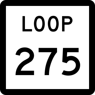
Loop 275 is a 9.454-mile (15.215 km), two-segment, state-maintained roadway located in Austin, Texas.

Moore's Crossing Historic District is a community located in rural Travis County nine miles southeast of Austin, Texas near the Austin–Bergstrom International Airport.

Downtown Austin is the central business district of Austin, Texas. The area of the district is bound by Lamar Boulevard to the west, Martin Luther King Jr. Boulevard to the north, Interstate 35 to the east, and Lady Bird Lake to the south.

South Congress is a neighborhood located on South Congress Avenue in Austin, Texas, United States. It is also a nationally known shopping and cultural district known for its many eclectic small retailers, restaurants, music and art venues and, more recently, food trucks.

Travis County has had two locations named Montopolis. The first was during the Republic of Texas period north of the Colorado River. The second is today's Montopolis neighborhood in Austin, Texas south of the river. Located southeast of the city's urban core, today's neighborhood is in ZIP code 78741. Montopolis is bounded by Lake Lady Bird on the north, by Grove Street and the Pleasant Valley neighborhood on the west, to the south by Texas State Highway 71, and by U.S. Route 183 on the east. The southeast corner abuts Austin-Bergstrom International Airport. Montopolis is in City Council District 3.
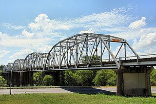
The Montopolis Bridge is a historic Parker through truss bridge in Austin, Texas. It is located in the Montopolis neighborhood where a bicycle and pedestrian walkway crosses the Colorado River in southeastern Travis County. The bridge consists of five 200-foot Parker through truss spans and four 52-foot steel I-beam approach spans resting on reinforced concrete abutments. It was added to the National Register of Historic Places on October 10, 1996.
South River City is a community located in Austin, Texas. Also frequently called Travis Heights, the neighborhood is located south of the city's urban core, just below Lake Lady Bird in South Austin. The area encompasses a portion of ZIP code 78704.

The 1839 Austin city plan is the original city plan for the development of Austin, Texas, which established the grid plan for what is now downtown Austin. It was commissioned in 1839 by the government of the Republic of Texas and developed by Edwin Waller, a Texian revolutionary and politician who would later become Austin's first mayor.

The 1928 Austin city plan was commissioned in 1927 by the City Council of Austin, Texas. It was developed by consulting firm Koch & Fowler, which presented the final proposal early the next year. The major recommendations of this city plan related to Austin's street plan, its zoning code, and the development of major industries and civic features, but it is most remembered for institutionalizing housing segregation by designating East Austin as the city's negro district.
 Bridge bats from below
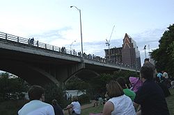 Tourists waiting for the bats.
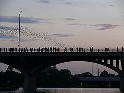 The emergence of the bats
 The bridge bats have become an integral part of Austin's cultural identity.


