Anstey, Leicestershire

Last updated

Anstey
AnsteyGateway20071026.jpg
'Anstey - Gateway to Charnwood Forest'
sign seen on entering the village
Leicestershire UK location map.svg
Red pog.svg
Anstey
Location within Leicestershire
Area6.25 sq mi (16.2 km2)
Population6,528 (2011 Census)
  Density 1,044/sq mi (403/km2)
OS grid reference SK545085
District
Shire county
Region
Country England
Sovereign state United Kingdom
Post town LEICESTER
Postcode district LE7
Dialling code 0116
Police Leicestershire
Fire Leicestershire
Ambulance East Midlands
UK Parliament
List of places
UK
England
Leicestershire
52°40′17″N1°11′44″W / 52.67148°N 1.19546°W / 52.67148; -1.19546

Anstey is a large village in Leicestershire, England, located north west of Leicester in the borough of Charnwood. Its population was 6,528 at the 2011 census. [1] This figure is expected to increase due to the building of a new housing development off Groby Road. The village is separated from Leicester by the Rothley Brook, Castle Hill Park and the A46, and it borders the villages of Glenfield, Groby, Newtown Linford, Cropston and Thurcaston as well as the suburb of Beaumont Leys and Anstey Heights. To the north-west lies Bradgate Park.

Contents

Anstey is known as the Gateway to Charnwood Forest. It is a combination of traditional English village (with two village greens - the top green and bottom green) and an industrial town (with several 19th-century hosiery factories, many of which are now being turned into apartments) which is made up mostly of a number of small estates, both council and private which are intertwined, often with no clear border.

History

Anstey dates back to Angle origins, when it was known as Hanstige (later Anstige), meaning a narrow forest track (specifically the meaning is either 'one-way' or 'steep road' [2] [3] ). Anstey was positioned between Charnwood Forest and Leicester Forest. [4]

Whilst developing the site for the new Co-op store in 2002 archaeologists were called in and found remains dating back to the 12th century. A plaque recording this has been placed on the wall of the new shop.

The place-name of Anstey is first recorded in Domesday Book when it was held by one of the county's largest landholders, Hugh de Grandmesnil, castellan of Leicester. [2] At the time it was a small farming community. [5]

Anstey appears to have had its origins in two distinct settlement foci, each associated with a separate manor, one associated with Leicester Abbey and one with the Ferrers of Groby. [2]

It is believed that Anstey once had a sizable military force - in 1431 William Porter "furnished XIX hommes and IX archers". [6]

When Bonnie Prince Charlie's army moved south during the 1745 rebellion, although the main body of troops were turned back at Derby, a foraging party reached the commons of Anstey. [6]

Local industry included hosiery from the eighteenth to the nineteenth century, leading to a rise in population to around 600 by 1800. [7] By 1845 there were 300 people employed as framework knitters in the village. [8] A decline in the industry in the middle of the nineteenth century saw a fall in the village's population, although hosiery manufacture continued in the village until the mid-twentieth century. [9] Boot and shoe manufacture became a more important part of the village's work between 1860 and 1900, and the first employer in Leicestershire described as a "boot and shoe manufacturer" appeared in Anstey in 1863. [10] The village's population rose to over 2,500 by 1900, with a corresponding rise in house-building. [9] Anstey became an independent parish in 1866, having previously been a chapelry of Thurcaston. [2] A number of related industries developed in the village, including tanning and box-making, the latter still present in the village. [11] One of the largest companies in the village was the Anstey Wallpaper Company, which occupied a site east of Cropston Road now filled with houses and the new Co-op store. Nearly all the local factories have now either been demolished or converted into flats. By 1971, the population of the village had risen to almost 6,000. [12] The village is still the home of Ulverscroft Large Print Books Ltd., known for their large-print editions of popular books, published since 1964. [13]

The most notable family of Anstey was the Martin family, who lived in the village from the 13th century until 1892. [14] Two members of the family held the position of Lord Lieutenant of Leicestershire, and the local high school is named after them. [14] They lived at Anstey Pastures (now demolished), [15] before moving to The Brand in 1892.

Famous past Anstey residents include Ned Ludd (Ludlam), [14] the machine-wrecker whose name was appropriated by the Luddites - whose name was adopted in a recent household development in the village: Ned Ludd Close, and snooker player and commentator Willie Thorne, who started playing snooker at the village's Conservative club. [16] Footballer Derek Dougan lived in the village during his time at Leicester City.

According to legend, the last wolf to be killed in England was shot in a forest "near Anstige in Wolfdale". [14] Wolfdale was a nearby district towards Newtown Linford, and the name has survived in a slightly altered form with Wooldale Close, one of the streets in the village.[ citation needed ]

Religion

St. Mary's parish church, Anstey Anstey Church.jpg
St. Mary's parish church, Anstey
Anstey Methodist Church AnsteyMethodist.jpg
Anstey Methodist Church

There are Church of England, United Reformed Church and Methodist churches in the village.

The parish church of St. Mary is on Bradgate Road, just out of The Nook, has the remains of a 15th-century preaching cross and was previously part of the Parish of Thurcaston.

The United Reformed Church is further up Bradgate Road.

The Methodist Church is situated near The Nook on Cropston Road, and is a medium-sized church serving the community, being part of the Leicester West Circuit of the Oxford and Leicester District of the Methodist Church. An earlier Methodist church was located on the opposite side of the road to the current church, until it was demolished in the 1980s.

Education

The earliest purpose-built school for children in Anstey was on Bradgate Road, built in 1873 and now a Grade II listed building that has been converted to flats; For many years after later schools were built this continued to serve as the village's infant school until it closed in 1982 whereupon the teaching of infants was relocated to nearby Latimer Primary School. There was also an Adult School & Institute on Church Lane, the building now occupied by a printing company. [17]

There are currently three schools in Anstey:

College students go to The Cedars Academy at Birstall. They may also go to English Martyrs RC School on Anstey Lane, Brookvale High School in Groby, or Rawlins Community College in Quorn (Out of catchment area).

The Martin High School

In March 2008, The Martin High was placed 10th best school in the country and 3rd best in the county for pupils' progress between the ages of 11 and 14. [18]

The village

Anstey retains some of the charm of a traditional village particularly on the area immediately north of the village centre, but due to its industrial background there are many small terraced houses as well as some pre-fabricated post war council houses in the 'Dutch barn' style. The large houses towards the top of Bradgate Road change into terraced houses in the old industrial area, and then modern suburbia out towards Link Road, where the Anstey Martin school can be found. Just off the Nook is Latimer primary school, named after Bishop Latimer.

King William's Bridge, Anstey King Williams Bridge Anstey 20071026.jpg
King William's Bridge, Anstey
Packhorse Bridge, Anstey PackhorseBridgeAnstey20071026 2.jpg
Packhorse Bridge, Anstey

The Rothley Brook flows through the village on its way to the River Soar, and there are two ancient bridges (the Packhorse Bridge and King William's Bridge) and an old water mill. The packhorse bridge is on the route of the original road from Leicester. King William's Bridge is so named because when King William III planned to visit the Grey family at Bradgate in 1696, the existing crossings of the Rothley Brook were found to be too narrow for the Royal coach, so a new bridge had to be constructed. [6]

Anstey also has a GP surgery, dentist, funeral directors and opticians, and several fast food outlets and restaurants. Around The Nook there are a number of different shops, a post office, as well as pubs - The Coach and Horses, The Crown and The Old Hare and Hounds as well as a Conservative club. The Working men's club closed in 2009 and The Plough pub in 2012.

In the past Anstey had two cinemas, the Savoy on Cropston Road which was later used as a petrol station/garage before being converted into a pub/restaurant and eventually a furnishings shop, and another on Ellis Street, which now sells wine.

Local newspaper

For many years, the village had its own newspaper, Anstey Scene, which was a quarterly with news about local events and council meetings. Other local publications included the Anstey Directory with advertisements for local businesses, including from the Birstall and Glenfield areas, and The Anstey Clarion, a monthly which took reader submitted articles. All of these have now ceased to publish. There is, however, a publication entitled Your Local which is published monthly.

Local area

Nearby Glenfield is the home of Leicestershire County Council, and all the shops and facilities of the city can be found about four miles (6 km) away in Leicester.

Castle Hill Park lies to the East of the village, connecting Anstey to Beaumont Leys and with the A46 Leicester Western Bypass running through it.

Bradgate Park, childhood home of Lady Jane Grey, stretches above the village, between the two neighbouring villages of Newtown Linford and Cropston. For transport, Anstey is served by regular bus services to Leicester and the Beaumont Shopping Centre (about a mile away in Beaumont Leys), and less regular services to Loughborough. By road, Anstey is just off the A46 Leicester Western Bypass, which provides a fast link to the M1 southbound to London, with the A50 providing access to the M1 North.

Sport

Anstey is home to Anstey Nomads Football Club who play in the East Midlands Counties League.

Prior to the Second World War there were two separate teams, the Methodist and St. Marys Parish Church football teams. However, following the War in 1947 the two teams merged and became Anstey Nomads. The ground, which is owned by the club, is situated on Cropston Road, Anstey. In addition to the Anstey Nomads there is the youth football team, Anstey Swifts. There also is another local football team, Anstey Town, who play in the Leicestershire Senior League.

There are also Rugby Union (Anstey RFC, formed 1980, who play on the Link Road playing fields) and Cricket teams, who play in the local leagues. Anstey and Glenfield CC play in the Leicestershire and Rutland Cricket League at Gynsill Lane playing field on the Anstey/Glenfield border, they have two senior teams playing in Division 6 and Division 8, one friendly XI playing numerous Sunday friendlies as of 2016. Anstey Narborians play on the recreation ground at Stadon Road, in the Leicestershire League.

Anstey has three recreation grounds - the main park ("The Reccy") off Stadon Road which has facilities including floodlit multi play/tennis court area, swings, slides, football pitch and a small area for younger children. From May 2009 it has a kicking wall and shelter to the side of the Jubilee Hall (APC office) built by Anstey Parish council. There is a less well equipped one near Link Road which is occasionally used by the Anstey RFC. Millfield Close also has a small area with play equipment on, which is rented from Charnwood Borough Council.

Ley lines

Standing stone, Anstey StoneAnstey20071026.jpg
Standing stone, Anstey

Anstey and surrounding area have been mentioned in several texts about ley lines. Anstey has a standing stone and a place called The Leys, which marks the route of the Bradgate Ley, which runs between a notch in the hill near Old John in Bradgate Park, and Oadby. [19]

Shopping

Anstey has a variety of different shops and services, making it the commercial centre for the majority of local villages. The largest shops include Potters Carpets & Kitchens, who decided to remain in the village despite the arson attack on their old building, [20] which remains to be a major source of income for the village, and a large Co-op store on Cropston Road. There were once several petrol stations in the village, although these have all now closed down. Two neighbouring petrol stations on Cropston Road are now occupied by Broughton's Interiors and a car dealer.

Transport

Anstey is served by frequent buses on First Leicester service 74 with some infrequent buses running on Centrebus service 154 and Roberts Travel service 120.

The nearest network railway station is at Leicester.

See also

Notes

  1. "Civil Parish population 2011". Neighbourhood Statistics. Office for National Statistics. Archived from the original on 11 October 2016. Retrieved 5 June 2016.
  2. 1 2 3 4 Courtney
  3. "Key to English Place-names". kepn.nottingham.ac.uk. Archived from the original on 1 July 2021. Retrieved 10 August 2021.
  4. "Andover - Anston | British History Online". www.british-history.ac.uk. Archived from the original on 24 September 2020. Retrieved 10 August 2021.
  5. Lowe, p. 1
  6. 1 2 3 "Leicestershire Villages - Anstey - Anstey History". Archived from the original on 14 October 2007. Retrieved 22 October 2007.
  7. Lowe, p. 10
  8. Lowe, p. 11
  9. 1 2 Lowe, p. 15
  10. Bailey, Brian J. (1977) Portrait of Leicestershire, Robert Hale Limited, London, ISBN   0-7091-6005-4, p. 205
  11. Lowe, p. 19
  12. Lowe, p. 20
  13. Cottin, Lou (1976) "Growing Older: Easier Reading Archived 1 August 2016 at the Wayback Machine ", Telegraph-Herald , 24 October 1976, p. 16, retrieved 2011-06-04
  14. 1 2 3 4 "Towns and Villages Around Leicester | Anstey". www.visitoruk.com. Archived from the original on 19 February 2020. Retrieved 25 March 2013.
  15. Burke, John & Burke, John Bernard (1847) A Genealogical and Heraldic History of the Landed Gentry of Great Britain & Ireland, Vol. II: M-Z, Henry Colburn, London, p. 833
  16. "BBC - Leicester Sense of Place - Looking for your landmarks". Archived from the original on 25 November 2013. Retrieved 20 December 2019.
  17. Friendly Societies, Industrial and Provident Societies, and Trade Unions, House of Commons, 1928, p. 4
  18. "Pupils Make Top Progress". Leicester Mercury . 7 March 2008. Archived from the original on 10 August 2021. Retrieved 5 April 2008.
  19. Timpson, John (2000) Timpson's Leylines, Cassell & Co., ISBN   1-84188-119-8, p.159
  20. "Two arrested after warehouse fire". BBC News. 25 February 2004. Archived from the original on 10 August 2021. Retrieved 25 April 2010.

Related Research Articles

<span class="mw-page-title-main">Borough of Charnwood</span> Borough in England

The Borough of Charnwood is a local government district with borough status in the north of Leicestershire, England, which has a population of 166,100 as of the 2011 census. It borders Melton to the east, Harborough to the south east, Leicester and Blaby to the south, Hinckley and Bosworth to the south west, North West Leicestershire to the west and Rushcliffe in Nottinghamshire to the north. It is named after Charnwood Forest, an area which the borough contains much of.

<span class="mw-page-title-main">Glenfield, Leicestershire</span> Human settlement in England

Glenfield is a large village and former civil parish, now in the parish of Glenfields, in the Blaby district of Leicestershire, England. At the 2011 Census, Glenfields had a population of 9,643. Its located at the northwestern fringe of the city of Leicester.

<span class="mw-page-title-main">Bradgate Park</span> 850 acre public park

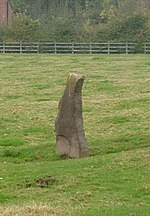
Bradgate Park is a public park in Charnwood Forest, in Leicestershire, England, northwest of Leicester. It covers 850 acres. The park lies between the villages of Newtown Linford, Anstey, Cropston, Woodhouse Eaves and Swithland. The River Lin runs through the park, flowing into Cropston Reservoir which was constructed on part of the park. To the north-east lies Swithland Wood. The park's two well known landmarks, Old John and the war memorial, both lie just above the 210 m (690 ft) contour. The park is part of the 399.3 hectare Bradgate Park and Cropston Reservoir Site of Special Scientific Interest, which has been designated under both biological and geological criteria.

<span class="mw-page-title-main">Groby</span> Human settlement in England

Grobylisten  is a large English village in the county of Leicestershire, to the north west of the city of Leicester. The population at the time of the 2011 census was 6,796.

<span class="mw-page-title-main">Rothley Brook</span> Stream in Leicestershire, England

The Rothley Brook is a left bank tributary of the River Soar in Leicestershire, England.

<span class="mw-page-title-main">Cropston Reservoir</span> Reservoir in Leicestershire

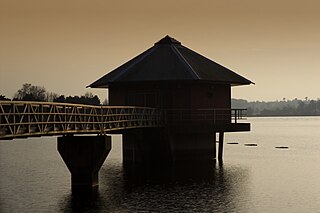
Cropston Reservoir lies in Charnwood Forest in Leicestershire, England. The dam and associated water works are in Cropston, while the bulk of the reservoir is in the neighbouring Newtown Linford parish. It was opened in May 1871 in a corner of Bradgate Park, a large expanse of open land northwest of Leicester. It is part of the 987-acre (399.3 ha) Bradgate Park and Cropston Reservoir Site of Special Scientific Interest.

<span class="mw-page-title-main">Cropston</span> Human settlement in England

Cropston is a village and former civil parish, now in the parish of Thurcaston and Cropston, part of the Borough of Charnwood in Leicestershire, England. It is on the edge of Charnwood Forest, and lies close to Bradgate Park. In 1931 the parish had a population of 404.

<span class="mw-page-title-main">Thurcaston</span> Human settlement in England

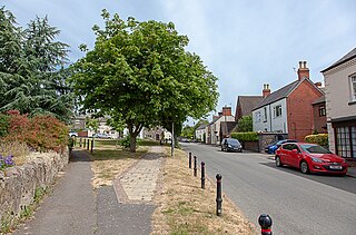
Thurcaston is a village and former civil parish, now in the parish of Thurcaston and Cropston, in the Charnwood district, in Leicestershire, England. It was the home of Bishop Hugh Latimer.

<span class="mw-page-title-main">Newtown Linford</span> Human settlement in England

Newtown Linford is a linear village in Leicestershire, England. The population of the civil parish was 1,000 at the 2001 census, including Ulverscroft, increasing to 1,103 at the 2011 census.

<span class="mw-page-title-main">Charnwood (UK Parliament constituency)</span> UK Parliament constituency since 1997

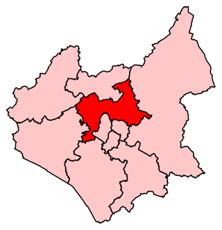
Charnwood is a constituency in Leicestershire represented in the House of Commons of the UK Parliament since 2015 by Edward Argar, a Conservative.

<span class="mw-page-title-main">Beaumont Leys</span> Suburb and electoral ward in north-western Leicester, England

Beaumont Leys is a suburb and electoral ward in north-western Leicester, in the Leicester district, in the ceremonial county of Leicestershire, England. The population of the ward at the 2011 census was 16,480. Locally, Beaumont Leys is usually used in reference to the large housing estate, built within the administrative division, centred on Strasbourg Drive.

<span class="mw-page-title-main">Markfield</span> Human settlement in England

Markfield is a large village in both the National Forest and Charnwood Forest and in the Hinckley and Bosworth district of Leicestershire, England. The settlement dates back to at least the time of the Norman conquest and is mentioned in the Domesday Book under the name Merchenefeld. A variant of this is still used as the name for the village primary school, Mercenfeld. It is to the south-east of Junction 22 of the M1, and to the south of the A50. The highest point in Markfield is shown on OS sheet 129 at 222 metres above sea level. Nearby places are Newtown Linford, Groby, Field Head, and Stanton under Bardon. In the 1841 census its population was recorded at 1,203. In the 2011 census the parish had a population of 5681. Markfield is within the LE67 postcode district. In 2012 Hinckley & Bosworth Borough Council published an overview of Markfield conservation area.

Thurcaston and Cropston is a civil parish in Leicestershire, England. As its name suggests, it consists of the villages of Thurcaston and Cropston. The parish had a population at the 2001 Census of 2,076, with around 1,200 in Cropston and 800 in Thurcaston. The population of the civil parish was 2,074 at the 2011 census. The villages are separated by the Rothley Brook.

Bradgate Electoral Division is a County Council electoral division in Leicestershire, England, taking its name from Bradgate Park which is at the centre of the division. It includes the villages of Anstey, Cropston, Thurcaston, Newtown Linford, Ulverscroft, Swithland, Woodhouse and Woodhouse Eaves, and is currently represented by Deborah Taylor.

<span class="mw-page-title-main">Swithland Reservoir</span> Reservoir in Leicestershire

Swithland Reservoir is a reservoir in the English county of Leicestershire. It is north-east of the village of Swithland from which it takes its name, north-west of Rothley and approximately 133 metres (145 yd) south-west of Mountsorrel Quarry. It is part of the 187.1-hectare (462-acre) Buddon Wood and Swithland Reservoir Site of Special Scientific Interest (SSSI).

<span class="mw-page-title-main">St Mary's Church, Anstey</span> Church in United Kingdom

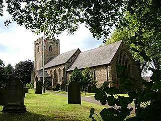
St Mary's Church is the Church of England parish church in Anstey, Leicestershire, in the Diocese of Leicester.

<span class="mw-page-title-main">River Lin</span> River in Leicestershire, England

The River Lin is a river which runs through North Leicestershire. The source of the river is in Ulverscroft, near Charnwood Forest. The river runs through Bradgate Park before the river runs into the River Soar in Quorn. The river also feeds Cropston Reservoir and Swithland Reservoir. The river runs for around 17 kilometres between its source and confluence with the River Soar. The river is described as one of Leicestershire's shortest rivers.

References