Cossington, Leicestershire

Last updated
Cossington
Cossington, Leicestershire - geograph.org.uk - 132192.jpg
Leicestershire UK location map.svg
Red pog.svg
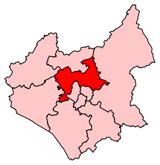
Cossington
Location within Leicestershire
Population598 
District
Shire county
Region
Country England
Sovereign state United Kingdom
Post town LEICESTER
Postcode district LE7
Police Leicestershire
Fire Leicestershire
Ambulance East Midlands
UK Parliament
List of places
UK
England
Leicestershire
52°42′58″N1°06′18″W / 52.716°N 1.105°W / 52.716; -1.105

Cossington parish church Cossington parish church 2006-04-14 019web.jpg
Cossington parish church

Cossington is a village within the Soar Valley in Leicestershire, England. [1] [2] It lies between Sileby, Rothley, Ratcliffe-on-the-Wreake and Syston. The population of the civil parish at the 2011 census was 598. [3]

The village's name means 'farm/settlement of Cusa/Cosa'. [4]

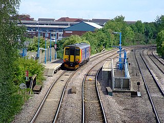
Although there is no railway service to Cossington, the Ivanhoe Line runs along the Midland Main Line between Leicester and Loughborough, passing close to the village. An hourly service is provided in both directions as part of East Midlands Railway Local service from Lincoln to Leicester via Nottingham. Many years ago there was a 'Cossington Gate railway station' which has long since gone, the only evidence remaining on old maps, The nearest stations now being at Syston and Sileby.

Cossington was once home to Lady Isobel Barnett, a radio and television personality from the mid 20th century, where she committed suicide amidst shoplifting charges. A short new road, Barnett Close, has been named in her memory.

The village is home to three small businesses; two garden centres (Derry's Nursery and Goscote Nursery) and a pub, The Royal Oak

In the early 1990s there were plans to expand the village, which were strongly opposed by the residents at the time, who formed the protest group 'Cossington In Distress'. The residents were successful in bringing about the cessation of the work and the village remains a peaceful community to this day.

Every alternate Easter the residents of Cossington open their gardens to the public for two days for the 'Secret Gardens of Cossington' in which the village's willing gardeners show off their talents, with all the proceeds of ticket sales going to charity. The event has been a massive success every time it has run.

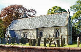
The church of All Saints dates from the 13th century. A ‘Grant of Arms’ of the Fisher family displayed on the tower wall above the arch. There are memorial tablets to the Fisher family of which Geoffrey Fisher became Archbishop of Canterbury in the 1950s. [5]

To the south of the village lies Platts Lane Recreation Ground (more simply known as just 'Platts Lane') which is owned by the Platts Lane Charitable Trust and run by a volunteer committee made up of mostly village residents. Platts Lane is basically a large playing field area and plays host to football, cricket and rugby matches - most notably being the home of Sileby Town Rugby Football Club who are also known as 'The Vikings' and play all their home fixtures at Platts Lane, which many locals enjoy watching.

Nearby is Ratcliffe College.

A notable native of Cossington was John Webster, governor of Connecticut Colony in 1656. John Webster's Great-great-great-grandson Noah Webster Jr Wrote what became the Merriam-Webster Dictionary around 1875

The Australian artist Grace Cossington Smith's mother (also Grace, née Fisher) was the daughter of a rector of Cossington from the Fisher family (see above).

To the east of the village there is a footpath named "Polly Peggs Footpath". Local village legend says a distressed girl drowned herself after falling pregnant whilst courting. Her lover, father and even the church abandoned her and she committed suicide. [6]

Related Research Articles

<span class="mw-page-title-main">Borough of Charnwood</span> Non-metropolitan district and borough in England

The Borough of Charnwood is a local government district with borough status in the north of Leicestershire, England, which has a population of 183,971 as of the 2021 census. It borders Melton to the east, Harborough to the southeast, Leicester and Blaby to the south, Hinckley and Bosworth to the southwest, North West Leicestershire to the west and Rushcliffe in Nottinghamshire to the north. It is named after Charnwood Forest, an area much of which lies within the borough.

<span class="mw-page-title-main">Frisby on the Wreake</span> Human settlement in England

Frisby on the Wreake is a village and civil parish on the River Wreake about 3.5 miles (5.6 km) west of Melton Mowbray, Leicestershire, England. The 2011 Census recorded the parish's population as 557.

<span class="mw-page-title-main">Cotes, Leicestershire</span> Human settlement in England

<span class="mw-page-title-main">Mountsorrel</span> Human settlement in England

Mountsorrel is a village in Leicestershire on the River Soar, just south of Loughborough with a population in 2001 of 6,662 inhabitants, increasing to 8,223 at the 2011 census.

<span class="mw-page-title-main">Ivanhoe line</span>

The Ivanhoe line was the local passenger service operated on the Midland Main Line between Leicester and Loughborough between 1993, when three intermediate stations were re-opened, and June 2005, when the separate Leicester–Loughborough service was withdrawn. Intermediate stations on the route are now served by East Midlands Railway's hourly service between Leicester, Nottingham and Lincoln.

<span class="mw-page-title-main">Birstall, Leicestershire</span> Human settlement in England

Birstall is a large village and civil parish within the Charnwood borough of Leicestershire, England. It is three miles north of Leicester city centre and is part of the wider Leicester Urban Area.

<span class="mw-page-title-main">Woodhouse, Leicestershire</span> Village in Leicestershire, England

Woodhouse, often known to locals as Old Woodhouse, is a small village and civil parish in the heart of Charnwood, England. The population of the civil parish at the 2011 census was 2,319, including around 300 term-time boarders at the Defence College. The parish includes the larger village of Woodhouse Eaves. The parish of Woodhouse was formed in 1844. The village is located between the larger Woodhouse Eaves and Quorn villages, the village contains a mixture of small cottages and large modern houses. It is a commuter village for both Leicester and Loughborough, as well as further afield.

<span class="mw-page-title-main">Charnwood (UK Parliament constituency)</span> UK Parliament constituency since 1997

Charnwood is a constituency in Leicestershire represented in the House of Commons of the UK Parliament since 2015 by Edward Argar, a Conservative.

<span class="mw-page-title-main">Sileby railway station</span> Railway station in Leicestershire, England

The Charnwood Forest Canal, sometimes known as the "Forest Line of the Leicester Navigation", was opened between Thringstone and Nanpantan, with a further connection to Barrow Hill, near Worthington, in 1794

<span class="mw-page-title-main">Ab Kettleby</span> Village in Leicestershire, England

Ab Kettleby is a village and civil parish in the Melton district of Leicestershire, England, located 3 miles (4.8 km) north of Melton Mowbray, on the A606 road. It had a population of 501 in 2001; at the 2011 census this had increased to 529.

<span class="mw-page-title-main">Ratcliffe on the Wreake</span> Human settlement in England

Ratcliffe on the Wreake is a village and civil parish in the Charnwood district of Leicestershire, England. The population of the civil parish at the 2011 census was 179. It is just to the north of the River Wreake, opposite East Goscote.

<span class="mw-page-title-main">Sileby</span> Human settlement in England

Sileby is a former industrial village and civil parish in the Soar Valley in the Charnwood borough of Leicestershire, England. It is located between Leicester and Loughborough. The village is close to Barrow upon Soar, Mountsorrel, Ratcliffe-on-the-Wreake, Seagrave and Cossington. The population of the civil parish at the 2011 census was 7,835, rising to 8,959 at the 2021 census.

<span class="mw-page-title-main">Stanford on Soar</span> Village in Nottinghamshire, England

Stanford on Soar, known locally as Stanford, is a village and civil parish in the Rushcliffe district of Nottinghamshire, England near the River Soar.

<span class="mw-page-title-main">East Goscote</span> Human settlement in England

East Goscote is a modern village and civil parish in the Borough of Charnwood district of Leicestershire, England, just north of the market town of Syston. It is a medium-sized village, with a population measured at 2,866 in the 2011 census. The village is twinned with Fleury-sur-Andelle, France.

<span class="mw-page-title-main">Costock</span> Village in Nottinghamshire, England

Costock is a village and civil parish in the Rushcliffe district of Nottinghamshire, England. The population of the civil parish at the 2011 Census was 621. It was estimated at 664 in 1998. Although in Nottinghamshire, Costock's closest town is Loughborough in Leicestershire.

<span class="mw-page-title-main">A607 road</span> Road in England

The A607 is an A road in England that starts in Belgrave, Leicester and heads northeastwards through Leicestershire and the town of Grantham, Lincolnshire, terminating at Bracebridge Heath, a village on the outskirts of Lincoln. It is a primary route from Thurmaston to the A1 junction at Grantham.

References

  1. Ordnance Survey: Landranger map sheet 129 Nottingham & Loughborough (Melton Mowbray) (Map). Ordnance Survey. 2014. ISBN   9780319231623.
  2. "Ordnance Survey: 1:50,000 Scale Gazetteer" (csv (download)). www.ordnancesurvey.co.uk. Ordnance Survey. 1 January 2016. Archived from the original on 3 March 2016. Retrieved 18 February 2016.
  3. "Civil Parish population 2011". Neighbourhood Statistics. Office for National Statistics. Retrieved 10 June 2016.
  4. "Key to English Place-names". kepn.nottingham.ac.uk. Archived from the original on 20 August 2021. Retrieved 20 August 2021.
  5. "Cossington Church All Saints". 12 February 2015. Archived from the original on 20 August 2021. Retrieved 19 October 2016.
  6. "The Ghost of Polly Peggs". 26 December 2016. Archived from the original on 2 February 2019. Retrieved 2 February 2019.

Commons-logo.svg Media related to Cossington, Leicestershire at Wikimedia Commons

52°42′58″N1°06′18″W / 52.716°N 1.105°W / 52.716; -1.105