
The Rocky Mountains, also known as the Rockies, are a major mountain range in western North America. The Rocky Mountains stretch more than 4,800 kilometers (3,000 mi) from the northernmost part of British Columbia, in western Canada, to New Mexico in the Southwestern United States. Located within the North American Cordillera, the Rockies are somewhat distinct from the Pacific Coast Ranges, Cascade Range, and the Sierra Nevada, which all lie farther to the west.

The Cascade Range or Cascades is a major mountain range of western North America, extending from southern British Columbia through Washington and Oregon to Northern California. It includes both non-volcanic mountains, such as the North Cascades, and the notable volcanoes known as the High Cascades. The small part of the range in British Columbia is referred to as the Canadian Cascades or, locally, as the Cascade Mountains. The latter term is also sometimes used by Washington residents to refer to the Washington section of the Cascades in addition to North Cascades, the more usual U.S. term, as in North Cascades National Park. The highest peak in the range is Mount Rainier in Washington at 14,411 feet (4,392 m).

The Canadian Rockies or Canadian Rocky Mountains comprise the Canadian segment of the North American Rocky Mountains. They are the eastern part of the Canadian Cordillera, which is a system of multiple ranges of mountains which runs from the Canadian Prairies to the Pacific Coast. The Canadian Rockies mountain system comprises the southeastern part of this system, lying between the Interior Plains of Alberta and Northeastern British Columbia on the east to the Rocky Mountain Trench of BC on the west. The southern end borders Idaho and Montana of the United States. In geographic terms the boundary is at the Canada/US border, but in geological terms it might be considered to be at Marias Pass in northern Montana. The northern end is at the Liard River in northern British Columbia.
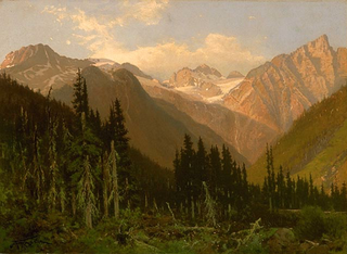
The Selkirk Mountains are a mountain range spanning the northern portion of the Idaho Panhandle, eastern Washington, and southeastern British Columbia. They begin at Mica Peak near Spokane and extend approximately 320 km north from the border to Kinbasket Lake, at the now-inundated location of the onetime fur company post Boat Encampment. The range is bounded on its west, northeast and at its northern extremity by the Columbia River, or the reservoir lakes now filling most of that river's course. From the Columbia's confluence with the Beaver River, they are bounded on their east by the Purcell Trench, which contains the Beaver River, Duncan River, Duncan Lake, Kootenay Lake and the Kootenay River. The Selkirks are distinct from, and geologically older than, the Rocky Mountains. Together with the neighboring Monashee and Purcell Mountains, and sometimes including the Cariboo Mountains to the northwest, the Selkirks are part of a larger grouping known as the Columbia Mountains. A scenic highway loop, the International Selkirk Loop, encircles the southern portions of the mountain range.

The Purcell Mountains are a mountain range in southeastern British Columbia, Canada. They are a subrange of the Columbia Mountains, which includes the Selkirk, Monashee, and Cariboo Mountains. They are located on the west side of the Rocky Mountain Trench in the area of the Columbia Valley, and on the east side of the valley of Kootenay Lake and the Duncan River. The only large settlement in the mountains is the Panorama Ski Resort and Kicking Horse Resort, though there are small settlements, such as Yahk and Moyie along the Crowsnest Highway, and residential rural areas dependent on the cities of Creston, Kimberley and Cranbrook, which are located adjacent to the range.

The Monashee Mountains are a mountain range lying mostly in British Columbia, Canada, extending into the U.S. state of Washington. They stretch 530 km (329 mi) from north to south and 150 km (93 mi) from east to west. They are a sub-range of the Columbia Mountains. The highest summit is Mount Monashee, which reaches 3,274 m (10,741 ft). The name is from the Gaelic monadh and sith, meaning "mountain" and "peace".

The Columbia Mountains are a group of mountain ranges along the upper Columbia River in southeastern British Columbia, and also in Montana, Idaho and Washington. The mountain range covers 135,952 km². The range is bounded by the Rocky Mountain Trench on the east, and the Kootenay River on the south; their western boundary is the edge of the Interior Plateau. Seventy-five percent of the range is located in Canada and the remaining twenty-five percent in the United States; American geographic classifications place the Columbia Mountains as part of the Rocky Mountains complex, but this designation does not apply in Canada. Mount Sir Sandford is the highest mountain in the range, reaching 3,519 metres (11,545 ft).

Monarch Mountain is one of the principal summits of the Pacific Ranges subdivision of the Coast Mountains in southern British Columbia. It stands just east of a pass between the Klinaklini River and the south branch of the Atnarko River, which is a tributary of the Bella Coola River. Surrounding Monarch Mountain is the Monarch Icefield, the northernmost of the major icefields of the Pacific Ranges, and just south of it is the Ha-Iltzuk Icefield, which is the largest. Monarch is in the southern end of Tweedsmuir South Provincial Park.

The Cariboo Mountains are the northernmost subrange of the Columbia Mountains, which run down into the Spokane, Washington area of the United States and include the Selkirks, Monashees and Purcells. The Cariboo Mountains are entirely within the province of British Columbia, Canada. The range is 7,700 km² in area and about 245 km in length (SE-NW) and about 90 km at its widest (SW-NE).
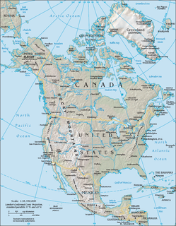
The North American Cordillera is the North American portion of the American Cordillera which is a mountain chain (cordillera) along the western side of the Americas. The North American Cordillera covers an extensive area of mountain ranges, intermontane basins, and plateaus in western North America, including much of the territory west of the Great Plains. It is also sometimes called the Western Cordillera, the Western Cordillera of North America, or the Pacific Cordillera.

The Vermilion Range is a mountain range of the Canadian Rockies, in Banff National Park, Canada. The range is east of the Sawback Range and west of the Bare and Palliser Ranges.
Anstey-Hunakwa Provincial Park is a provincial park in the Shuswap Country of the Southern Interior of British Columbia, Canada. 6,852 hectares in size, the park was established April 18, 2001.

The Premier Range is a group of mountains within the Cariboo Mountains of east-central British Columbia, Canada. The range is bounded by the Raush River and Kiwa Creek to the north, the North Thompson River on the south and west and the Fraser River and its tributaries to the east.

The Omineca Mountains, also known as "the Ominecas", are a group of remote mountain ranges in north-central British Columbia, Canada. They are bounded by the Finlay River on the north, the Rocky Mountain Trench on the east, the Nation Lakes on the south, and the upper reaches of the Omineca River on the west. They form a section of the Continental Divide, that, in this region, separates water drainage between the Arctic and Pacific Oceans. The lower course of the Omineca River flows through the heart of the range. To the south of the Ominecas is the Nechako Plateau, to the west the Skeena Mountains and Hazelton Mountains, to the north the Spatsizi Plateau and the Stikine Ranges, while east across the Rocky Mountain Trench are the Muskwa Ranges.

The Hazelton Mountains are a grouping of mountain ranges on the inland lee of the Kitimat Ranges of the Coast Mountains in northwestern British Columbia, Canada, spanning the area of Hazelton south to the Nechako Reservoir. Defined by the British Columbia geographic names office, they span from the Nass River to the Nechako Plateau, and between the Coast Mountains and the Bulkley River, they are considered by geographers to be part of the Interior Mountains complex, though in local perspective they are considered to be part of the Coast Mountains. They are neighboured on the west by the Kitimat Ranges and on the east by the southernmost section of the Skeena Mountains; beyond the Nass River, which is their northern boundary, are the Boundary Ranges of the Coast Mountains. To their southeast is the Nechako Plateau, including the Quanchus Range on the near-island between Ootsa and Eutsuk Lakes of the Nechako Reservoir.

The Hart Ranges are one of the main geographic subdivisions of the Canadian Rockies and are the main part of the area that is meant by the Northern Rockies, although the much larger Muskwa Ranges to the north are more deserving of that term — but also much more inaccessible and much less visited — and the Northern Rockies are generally also considered to extend at least as far south as Mount Robson, which is in the Continental Ranges. The Hart Ranges were named in honour of British Columbia Premier John Hart, as is the highway which traverses the Pine Pass in the northern part of the range, connecting the north-central Interior of the province to its Peace River District to the northeast.
The Thudaka Range is a mountain range located east of the Rocky Mountain Trench in British Columbia, Canada bounded by the Obo River on the east, the Frog River on the west, and on the south by the pass between Geese and Thudaka Creeks. The highest peak in the range is Thudaka Peak at 2,748 m (9,016 ft). The range is part of the Stikine Ranges.
The Wavy Range is a small mountain range east of Murtle Lake in east-central British Columbia, Canada. It has an area of 102 km2 and is a subrange of the Cariboo Mountains which in turn form part of the Columbia Mountains.
The Lizard Range is a mountain range south-east of Fernie, British Columbia in the Canadian Rockies. This range is home to the Fernie Alpine Resort and parts of the Mount Fernie Provincial Park.
The Anstey River is a 30 kilometer long river in the Interior region of British Columbia, Canada. It flows roughly north to south from the Monashee range of the Columbia Mountains, and drains into Anstey Arm on Shuswap Lake. The Anstey River drainage covers 24,000 hectares and is uninhabited. The river was named for Francis Senior Anstey, who operated one of the first major logging operations in the area. The lower river and its delta are protected within Anstey Hunakwa Provincial Park.


