Related Research Articles

The Monashee Mountains are a mountain range lying mostly in British Columbia, Canada, extending into the U.S. state of Washington. They stretch 530 km (329 mi) from north to south and 150 km (93 mi) from east to west. They are a sub-range of the Columbia Mountains. The highest summit is Mount Monashee, which reaches 3,274 m (10,741 ft). The name is from the Gaelic monadh and sith, meaning "mountain" and "peace".

The Columbia Mountains are a group of mountain ranges along the upper Columbia River in southeastern British Columbia, and also in Montana, Idaho and Washington. The mountain range covers 135,952 km². The range is bounded by the Rocky Mountain Trench on the east, and the Kootenay River on the south; their western boundary is the edge of the Interior Plateau. Seventy-five percent of the range is located in Canada and the remaining twenty-five percent in the United States; American geographic classifications place the Columbia Mountains as part of the Rocky Mountains complex, but this designation does not apply in Canada. Mount Sir Sandford is the highest mountain in the range, reaching 3,519 metres (11,545 ft).

Sandon is a ghost town in the Kootenay region of British Columbia, Canada. Once the unofficial capital of the mining region known as the "Silvery Slocan", only some of it remains standing.

The Golden Hinde is a mountain located in the Vancouver Island Ranges on Vancouver Island, British Columbia, Canada. At 2,195 metres (7,201 ft), it is the highest peak on the island. The mountain is located near the geographic centre of Vancouver Island, as well as near the centre of 2,450 km2 Strathcona Provincial Park, at the head of the Wolf River and to the west of Buttle Lake, about 25 kilometres (16 mi) east of the community of Gold River. The peak is popular with experienced backcountry-climbers, having been first ascended in 1913. The mountain is made of basalt which is part of the Karmutsen Formation.
Vavenby is a community of approximately 700 residents located in the province of British Columbia, Canada. Economy in the region centres primarily on forestry, logging, agriculture, and tourism. Adjacent to the community lies the North Thompson River, the Yellowhead Highway (#5) and the Canadian National Railway.
Winlaw is a small unincorporated community, located in the Slocan Valley region of the West Kootenay area in southeastern British Columbia, Canada. The town of Winlaw originally centered on a lumber mill that once stood where Winlaw Elementary School is. Winlaw was named after John Brown Winlaw who also pioneered in Wynndel. In 1900 he founded a lumber mill in the area and in 1903 became the first postmaster.

Skihist Mountain, also sometimes referred to as Skihist Peak, is the highest mountain in the Cantilever Range and in southwestern British Columbia, Canada. It is located on the southern boundary of Stein Valley Nlaka'pamux Heritage Park, about 20 km (12 mi) west of Lytton. It is the highest summit in the Lillooet Ranges, which lie between the Lillooet and Fraser Rivers, south of the Gates Valley and Seton and Anderson Lakes.
The Caren Range is a low and mostly tree-covered mountain range in the Pacific Ranges of the Coast Mountains in southwestern British Columbia, Canada. It lies along the eastern shore of the Sechelt Peninsula, southeast of Sakinaw Lake, about 74 km northwest of Vancouver. It has an area of 169 km2 and contains Spipiyus Provincial Park. The name of the range is a long standing misinterpretation of Carew. It was named for Benjamin Hallowell Carew. The range is noted for its ancient trees.

Slocan Lake is a lake in the Slocan Valley of the West Kootenay region of the Southeastern Interior of British Columbia, Canada. it is drained by the Slocan River, which flows south from the lake's foot at Slocan City through the Slocan Valley to South Slocan, British Columbia, where that river meets the Kootenay River a few miles above its confluence with the Columbia. It is fed by Bonanza Creek, which comes down the pass from Summit Lake, beyond which is the town of Nakusp on Upper Arrow Lake.
The Butler Range is a subrange of the Finlay Ranges of the Omineca Mountains, located on the west side of Finlay Reach in northern British Columbia, Canada.
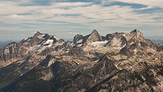
The Valhalla Ranges are a subrange of the Selkirk Mountains of the Columbia Mountains in southeastern British Columbia, Canada, located between Lower Arrow Lake of the Arrow Lakes and Slocan River.
The Battle of Britain Range is a group of mountains within the Allies Group of the Muskwa Ranges in northern British Columbia, Canada. The Muskwa Ranges also include the Tower of London Range, Italy Range and Allied Leaders Range.

Gladsheim Peak is a prominent 2,830-metre (9,280-foot) mountain summit located in the Valhalla Ranges of the Selkirk Mountains in British Columbia, Canada. Gladsheim is the highest point in the Valhalla Ranges. It is situated in the southern part of Valhalla Provincial Park, 2.7 km (1.7 mi) northeast of Gimli Peak, and 12 km (7.5 mi) west of Slocan and Slocan Lake. The name "Valhalla Mountains" first appeared in George Mercer Dawson's Geological Survey of Canada map published in 1890. Dawson applied names derived from Scandinavian mythology to several of the mountain ranges and peaks in Southern Kootenay. Gladsheim is the magnificent meeting hall containing thirteen council seats where, according to Norse mythology, Odin presided over all the realms. In keeping with the Valhalla theme, this peak's name was submitted in 1900 by R. W. Brock to the Geological Survey of Canada for consideration, and it was officially adopted March 31, 1924, by the Geographical Names Board of Canada. Based on the Köppen climate classification, Gladsheim Peak has a subarctic climate with cold, snowy winters, and mild summers. Temperatures can drop below −20 °C with wind chill factors below −30 °C. Precipitation runoff from the mountain drains into Gwillim Creek and Mulvey Creek, both tributaries of the Slocan River. Its nearest higher peak is Mount Cooper, 49.0 km (30.4 mi) to the northeast.

Gregorio Peak is a 2,605-metre (8,547-foot) mountain summit located in the Valhalla Ranges of the Selkirk Mountains in British Columbia, Canada. It is situated on the southwestern border of Valhalla Provincial Park, 8.7 km (5.4 mi) west of Gladsheim Peak, and 19 km (12 mi) west of Slocan and Slocan Lake. The mountain's name commemorates Michael Gregory, a resident of the Slocan area known to his friends as Gregorio, who drowned in a canoeing accident on Slocan Lake in 1971 returning from a climb of nearby Devils Couch. This peak's name was submitted by Anthony Eweson of New Denver for consideration, and it was officially adopted March 4, 1974, by the Geographical Names Board of Canada. Based on the Köppen climate classification, Gregorio Peak has a subarctic climate with cold, snowy winters, and mild summers. Temperatures can drop below −20 °C with wind chill factors below −30 °C. Precipitation runoff from the mountain drains into Gwillim Creek and Hoder Creek, both tributaries of the Slocan River. Its nearest higher peak is Lucifer Peak, 2.8 km (1.7 mi) to the north-northeast. The first ascent of the peak was made August 25, 1970, by Bob Dean and Howie Ridge.

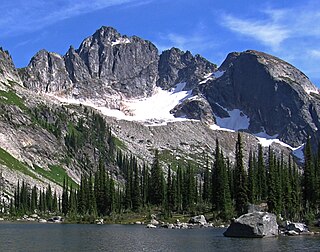
Devils Couch is a 2,749-metre (9,019-foot) mountain summit located in the Valhalla Ranges of the Selkirk Mountains in southeast British Columbia, Canada. It is situated in Valhalla Provincial Park, 5 km (3.1 mi) north of Gladsheim Peak, 12 km (7.5 mi) west of Slocan Lake, and 15 km (9.3 mi) northwest of Slocan. The mountain's descriptive name refers to its shape. It was first called "The Toboggan Slide" by early miners who arrived in the area in the 1890s. It was later called "King Tuts Couch" in the 1920s, coinciding with the archaeological discovery in Egypt. This peak's current name was officially adopted July 22, 1964, by the Geographical Names Board of Canada. The peak is located in Devils Range, which is a subrange of the Valhallas. The names of the peaks of this small compact range have a devil-related theme: Black Prince Mountain, Lucifer Peak, Mount Mephistopheles, Devils Dome, Mount Diablo, Satan Peak, and Devils Spire. Based on the Köppen climate classification, Devils Couch has a subarctic climate with cold, snowy winters, and mild summers. Temperatures can drop below −20 °C with wind chill factors below −30 °C. Precipitation runoff from the mountain drains into Gwillim Creek and Evans Creek, both tributaries of the Slocan River.

Asgard Peak is a 2,825-metre (9,268-foot) mountain summit located in the Valhalla Ranges of the Selkirk Mountains in British Columbia, Canada. Asgard Peak is the second-highest point in the Valhalla Ranges, with the highest being Gladsheim Peak, 2.1 km (1.3 mi) to the east. It is situated in the southern part of Valhalla Provincial Park, 6 km (3.7 mi) south of Devils Couch, and 13 km (8.1 mi) west of Slocan and Slocan Lake. The name "Valhalla Mountains" first appeared in George Mercer Dawson's Geological Survey of Canada map published in 1890. Dawson applied names derived from Scandinavian mythology to several of the mountain ranges and peaks in Southern Kootenay. In keeping with the Valhalla theme, this peak's name was submitted February 1970 by Robert Dean of the Kootenay Mountaineering Club for consideration, and it was officially adopted March 3, 1971, by the Geographical Names Board of Canada. Asgard, according to Norse mythology, is the section of Valhalla where the twelve gods dwell. Based on the Köppen climate classification, Asgard Peak has a subarctic climate with cold, snowy winters, and mild summers. This climate supports a small glacier on the peak's north slope. Temperatures can drop below −20 °C with wind chill factors below −30 °C. Precipitation runoff from the mountain drains into tributaries of the Slocan River.

Midgard Peak is a 2,807-metre (9,209-foot) mountain summit located in the Valhalla Ranges of the Selkirk Mountains in British Columbia, Canada. Midgard Peak is the third-highest point in the Valhalla Ranges, with the highest being Gladsheim Peak, 2.9 km (1.8 mi) to the east-northeast. Its nearest higher peak is Asgard Peak, 0.9 km (0.56 mi) to the northeast. It is situated on the southern border of Valhalla Provincial Park, 1.1 km (0.68 mi) northwest of Gimli Peak, and 14 km (8.7 mi) west of Slocan and Slocan Lake. The name "Valhalla Mountains" first appeared in George Mercer Dawson's Geological Survey of Canada map published in 1890. Dawson applied names derived from Scandinavian mythology to several of the mountain ranges and peaks in Southern Kootenay. In keeping with the Valhalla theme, this peak's name was submitted February 1970 by Robert Dean of the Kootenay Mountaineering Club for consideration, and it was officially adopted March 3, 1971, by the Geographical Names Board of Canada. According to Norse mythology, Midgard is the home of earth dwellers. Based on the Köppen climate classification, Midgard Peak has a subarctic climate with cold, snowy winters, and mild summers. Temperatures can drop below −20 °C with wind chill factors below −30 °C. Precipitation runoff from the mountain drains into tributaries of the Slocan River.
Drinnan Peak is a 2,584-metre (8,478-foot) mountain summit located in the Valhalla Ranges of the Selkirk Mountains in southeast British Columbia, Canada. It is situated on the southwestern border of Valhalla Provincial Park, 2.8 km (1.7 mi) southeast of Gregorio Peak, and 18 km (11 mi) west of Slocan and Slocan Lake. The mountain is named for Bill Drinnan who trapped in the vicinity in the 1920s and 1930s. Drinnon Peak was adopted in 1976 in association with Drinnon Lake. To conform with the correct spelling of the family name, the spelling was changed to Drinnan Peak, and officially adopted February 3, 1986, by the Geographical Names Board of Canada. Based on the Köppen climate classification, Drinnan Peak has a subarctic climate with cold, snowy winters, and mild summers. Temperatures can drop below −20 °C with wind chill factors below −30 °C. Precipitation runoff from the mountain drains into Gwillim Creek and Hoder Creek, both tributaries of the Slocan River. Its nearest higher peak is Mount Prestley, 2 km (1.2 mi) to the southeast. The first ascent of the peak was made August 19, 1974, by Bob Dean, Janice Isaac, Kim Kratky, and Peter Wood.
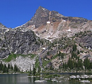
Lucifer Peak is a 2,726-metre (8,944-foot) mountain summit located in the Valhalla Ranges of the Selkirk Mountains in southeast British Columbia, Canada. It is situated in western Valhalla Provincial Park, 8.8 km (5.5 mi) west-northwest of Gladsheim Peak, 18 km (11 mi) west of Slocan Lake, and 20 km (12 mi) west-northwest of Slocan. This peak's name was officially adopted July 26, 1977, by the Geographical Names Board of Canada. The peak is located in Devils Range, which is a subrange of the Valhallas. The names of the peaks of this small compact range have a devil-related theme: Black Prince Mountain, Mount Mephistopheles, Devils Dome, Mount Diablo, Satan Peak, Devils Spire, and Devils Couch. Based on the Köppen climate classification, Lucifer Peak has a subarctic climate with cold, snowy winters, and mild summers. Temperatures can drop below −20 °C with wind chill factors below −30 °C. Precipitation runoff from the mountain drains into Gwillim Creek and Evans Creek, both tributaries of the Slocan River. The first ascent of the peak was made August 24, 1970, by Bob Dean and Howie Ridge via the east ridge.

Devils Dome is a 2,769-metre (9,085-foot) mountain summit located in the Valhalla Ranges of the Selkirk Mountains in southeast British Columbia, Canada. It is situated in western Valhalla Provincial Park, 1.5 km (0.93 mi) east of Lucifer Peak, 5 km (3.1 mi) west of Devils Couch, and 18 km (11 mi) west of Slocan and Slocan Lake. The peak is located in Devils Range, which is a subrange of the Valhallas. Devils Dome has a subpeak, unofficially called Dark Prince, 100 meters to the west. The names of the peaks of this small compact range have a devil-related theme: Black Prince Mountain, Lucifer Peak, Mount Mephistopheles, Mount Diablo, Satan Peak, Devils Spire, and Devils Couch. This peak's name was submitted by Pat Ridge of the Kootenay Mountaineering Club and officially adopted July 27, 1977, by the Geographical Names Board of Canada. Based on the Köppen climate classification, Devils Dome has a subarctic climate with cold, snowy winters, and mild summers. Temperatures can drop below −20 °C with wind chill factors below −30 °C. Precipitation runoff from the mountain drains into Gwillim Creek and Evans Creek, both tributaries of the Slocan River. The first ascent of the peak was made in 1973 by Howie Ridge, Peter Wood, and G. Stein via the southeast ridge.
References
- ↑ Akrigg, G.P.V.; Akrigg, Helen B. (1986), British Columbia Place Names (3rd, 1997 ed.), Vancouver: UBC Press, ISBN 0-7748-0636-2
- "Norns Range". BC Geographical Names.
- Norns Range in the Canadian Mountain Encyclopedia
| This article about a location in the Interior of British Columbia, Canada is a stub. You can help Wikipedia by expanding it. |