Antonine Itinerary

Last updated
Iter Britanniarum, displayed as a road map. The plotted routes and stations are approximations. The Antonine Wall and Hadrian's Wall are shown. Iter.Britanniarum.jpg
Iter Britanniarum, displayed as a road map. The plotted routes and stations are approximations. The Antonine Wall and Hadrian's Wall are shown.

The Antonine Itinerary (Latin : Itinerarium Antonini Augusti, "Itinerary of the Emperor Antoninus") is an itinerarium , a register of the stations and distances along various roads. Seemingly based on official documents, possibly in part from a survey carried out under Augustus, it describes the roads of the Roman Empire. [1] Owing to the scarcity of other extant records of this type, it is a valuable historical record. [2]

Contents

Almost nothing is known of its author or the conditions of its compilation. Numerous manuscripts survive, the eight oldest dating to some point between the 7th to 10th centuries after the onset of the Carolingian Renaissance. [3] Despite the title seeming to ascribe the work to the patronage of the 2nd-century Antoninus Pius, all surviving editions seem to trace to an original towards the end of the reign of Diocletian in the early 4th century. [3] The most likely imperial patron—if the work had one—would have been Caracalla. [1]

Iter Britanniarum

The British section is known as the Iter Britanniarum, and can be described as the 'road map' of Roman Britain. There are 15 such itineraries in the document applying to different geographic areas.

The itinerary measures distances in Roman miles, where 1,000 Roman paces equals one Roman mile. A Roman pace was two steps, left plus right, and was conventionally set at 5 Roman feet (0.296m), resulting in a Roman mile of approximately 1,480 metres (0.92 mi).

Examples

Below are the original Latin ablative forms for sites along route 13, [4] followed by a translation with a possible (but not necessarily authoritative) name for the modern sites. [5] A transcriber omitted an entry, so that the total number of paces did not equal the sum of paces between locations.

Iter XIII (Itinerary 13)
Latin ablativeTranslated possible site nameDistance
Roman (mile)Metric (km)English (mile)
Item ab Isca Calleva mpm [6] cviiii [7] sicA route from Isca Silurum to Calleva Atrebatum thus109161100
Burrio mpm viii Usk, Monmouthshire8127.5
Blestio mpm xi Monmouth, Monmouthshire111610
Ariconio mpm xiBury Hill, Weston under Penyard, Herefordshire111610
Clevo mpm xv Gloucester, Gloucestershire152214
(no entry - mpm xx)perhaps Corinium Dobunnorum at modern Cirencester, Gloucestershire(20)(30)(18.5)
Durocornovio mpm xiiiiperhaps Wanborough, Wiltshire 142113
Spinis mpm xv Speen, Berkshire 152214
Calleva mpm xv Silchester, Hampshire152214

Below are the original Latin names for sites along route 14, [8] followed by a translation with a possible (but not necessarily authoritative) name for the modern sites. [5]

Iter XIV (Itinerary 14)
Latin ablativeTranslated possible site nameDistance
Roman (mile)Metric (km)English (mile)
Item alio itinere ab Isca Calleva mpm ciii sicAn alternate route from Isca Silurum to Calleva Atrebatum thus10315295
Venta Silurum mpm viiii Caerwent, Monmouthshire9138
Abone mpm xiiii Sea Mills, Gloucestershire142113
Traiectus mpm viiiiperhaps Bitton, near Willsbridge, Gloucestershire9138
Aquis Solis mpm vi Bath, Somerset 695.5
Verlucione mpm xv Sandy Lane, Wiltshire 152214
Cunetione mpm xx Mildenhall, Wiltshire 203018.5
Spinis mpm xv Speen, Berkshire 152214
Calleva mpm xv Silchester, Hampshire152214

A confounding factor

De Situ Britanniae (made available c.1749, published 1757) was a forgery by Charles Bertram that provided much spurious information on Roman Britain, including "itineraries" that overlapped the legitimate Antonine Itineraries, sometimes with contradicting information. Its authenticity was not seriously challenged until 1845, and it was still cited as an authoritative source until the late nineteenth century. By then, its false data had infected almost every account of ancient British history, and had been adopted into the Ordnance Survey maps, [9] as General Roy and his successors believed it to be a legitimate source of information, on a par with the Antonine Itineraries. While the document is no longer cited since its authenticity became indefensible, its data has not been systematically removed from past and present works.

Some authors, such as Thomas Reynolds, without challenging the authenticity of the forgery, took care to note its discrepancies and challenge the quality of its information. [10] [11] This was not always so, even after the forgery was debunked.

Gonzalo Arias (died 2008) proposed that some of the distance anomalies in the British section of the Antonine Itinerary resulted from the loss of Latin grammatical endings, as these had marked junctions heading towards places, as distinct from the places themselves. [12] However, Arias may not have taken account of earlier work indicating that distances were measured between the edges of administrative areas of named settlements as opposed to centre-to-centre, thereby explaining supposed distance shortfalls and providing additional useful data on the approximate sizes of such areas. [13]

Hispania

Main Roman roads in Hispania Hispania roads.svg
Main Roman roads in Hispania
Roads listed on the Itinerary MAPA ANTONINO.png
Roads listed on the Itinerary

There are 34 routes in the itinerary for the provinces of Hispania.

RouteStartEndDistance (Roman miles)
1Mediolanum (Milan) Legio VII Gemina (León)1257
2Arelate (Arles) Castulo 898
3Corduba (Córdoba)Castulo99
4CordubaCastulo78
5CastuloMalaca (Málaga)291
6MalacaGades (Cádiz)145
7GadesCorduba294
8Hispalis (Seville)Corduba94
9Hispalis Italica 6
10Hispalis Emerita (Mérida)162
11CordubaEmerita144
12 Olisipo (Lisbon)Emerita161
13Salacia (Alcácer)Ossonoba (Faro)16
14OlisipoEmerita145
15OlisipoEmerita220
16Olisipo Bracara (Braga)244
17BracaraAsturica (Astorga)247
18 BracaraAsturica215
19BracaraAsturica299
20BracaraAsturica207
21Esuris (Castro Marim) Pax Julia 267
22EsurisPax Julia76
23Mouth of the Ana (Guadiana)Emerita313
24Emerita Caesaraugusta (Zaragoza)632
25Emerita Caesaraugusta 348
26Asturica Caesaraugusta 497
27Asturica Caesaraugusta 301
28Turiaso (Tarazona) Caesaraugusta 56
29Emerita Caesaraugusta 458
30 Laminium (Fuenllana)Toletum (Toledo)95
31 Laminium Toletum249
32Asturica Tarraco (Tarragona)482
33CaesaraugustaBenearnum (Lescar)112
34 AsturicaBurdigala (Bordeaux)421

See also

Related Research Articles

<span class="mw-page-title-main">Watling Street</span> Historic route in England

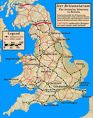
Watling Street is a historic route in England that crosses the River Thames at London and which was used in Classical Antiquity, Late Antiquity, and throughout the Middle Ages. It was used by the ancient Britons and paved as one of the main Roman roads in Britannia. The route linked Dover and London in the southeast, and continued northwest via St Albans to Wroxeter. The line of the road was later the southwestern border of the Danelaw with Wessex and Mercia, and Watling Street was numbered as one of the major highways of medieval England.

<span class="mw-page-title-main">Roman roads in Britannia</span> Roads in the Province of Britannia, 43–410

Roman roads in Britannia were initially designed for military use, created by the Roman army during the nearly four centuries (AD 43–410) that Britannia was a province of the Roman Empire.

<span class="mw-page-title-main">High Cross, Leicestershire</span> Historic site and locality in England

High Cross is the name given to the crossroads of the Roman roads of Watling Street and Fosse Way on the border between Leicestershire and Warwickshire, England. A naturally strategic high point, High Cross was "the central cross roads" of Anglo-Saxon and Roman Britain. It was the site of a Romano-British settlement known as Venonae or Venonis, with an accompanying fort.

<span class="mw-page-title-main">Dere Street</span> Roman road that ran from York in England to the Antonine Wall in Scotland

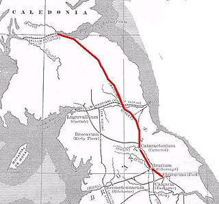
Dere Street or Deere Street is a modern designation of a Roman road which ran north from Eboracum (York), crossing the Stanegate at Corbridge and continuing beyond into what is now Scotland, later at least as far as the Antonine Wall. It was the Romans' major route for communications and supplies to the north and to Scotland. Portions of its route are still followed by modern roads, including the A1(M), the B6275 road through Piercebridge, where Dere Street crosses the River Tees, and the A68 north of Corbridge in Northumberland.

<span class="mw-page-title-main">Itinerarium</span> Ancient Roman travel guide in the form of a list

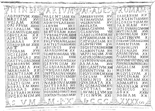
An itinerarium was an ancient Roman travel guide in the form of a listing of cities, villages (vici) and other stops on the way, including the distances between each stop and the next. Surviving examples include the Antonine Itinerary and the Bordeaux Itinerary.

<span class="mw-page-title-main">Durobrivae (Water Newton)</span>

Durobrivae was a Roman fortified garrison town located at Water Newton in the English county of Cambridgeshire, where Ermine Street crossed the River Nene. More generally, it was in the territory of the Corieltauvi in a region of villas and commercial potteries. The name is a Latinisation of Celtic *Durobrīwās, meaning essentially "fort bridges".

<span class="mw-page-title-main">Thomas Gale</span> British antiquarian

Thomas Gale was an English classical scholar, antiquarian and cleric.

<span class="mw-page-title-main">Ancaster (Roman town)</span>

Ancaster was a small town in the Roman province of Britannia. It is sited on the Roman road known as the Ermine Street and is situated in the county of Lincolnshire. Its name in Latin is unknown, although it has traditionally been identified with Causennis or Causennæ, a name which occurs as a town on the route of Iter V recorded in the Antonine Itinerary. Rivet and Smith questioned this identification in 1979, and suggested that a more likely identification would be either the Roman settlement at Salters ford, near Grantham in Lincolnshire, or at Sapperton in Lincolnshire.

<span class="mw-page-title-main">Steep Hill</span> Street in Lincoln, Lincolnshire, England

Steep Hill is a street in the historic city of Lincoln, Lincolnshire, England. At the top of the hill is the entrance to Lincoln Cathedral and at the bottom is Well Lane. The Hill consists of independent shops, tea rooms and pubs.

The Description of Britain, also known by its Latin name De Situ Britanniae, was a literary forgery perpetrated by Charles Bertram on the historians of England. It purported to be a 15th-century manuscript by the English monk Richard of Westminster, including information from a lost contemporary account of Britain by a Roman general, new details of the Roman roads in Britain in the style of the Antonine Itinerary, and "an antient map" as detailed as the works of Ptolemy. Bertram disclosed the existence of the work through his correspondence with the antiquarian William Stukeley by 1748, provided him "a copy" which was made available in London by 1749, and published it in Latin in 1757. By this point, his Richard had become conflated with the historical Richard of Cirencester. The text was treated as a legitimate and major source of information on Roman Britain from the 1750s through the 19th century, when it was progressively debunked by John Hodgson, Karl Wex, B. B. Woodward, and John E. B. Mayor. Effects from the forgery can still be found in works on British history and it is generally credited with having named the Pennine Mountains.

<span class="mw-page-title-main">Ariconium</span> Ancient place in Roman Britain

Ariconium was a road station of Roman Britain mentioned in Iter XIII of the Iter Britanniarum of the Antonine Itineraries. It was located at Bury Hill in the parish of Weston under Penyard, about 3 miles (5 km) east of Ross on Wye, Herefordshire, and about 15 miles (24 km) southeast of Hereford. The site existed prior to the Roman era, and then came under Roman control. It was abandoned, perhaps shortly after 360, but precisely when and under what circumstances is unknown.

Thomas Reynolds (1752–1829) was an English antiquarian and minister.

Caenophrurium was a settlement in the Roman province of Europa, between Byzantium and Heraclea Perinthus. It appears in late Roman and early Byzantine accounts. Caenophrurium translates as the "stronghold of the Caeni", a Thracian tribe.

Noviomagus is a Latinization of a Brittonic placename meaning "new plain" or "new fields", a clearing in woodland. The element Cantiacorum distinguishes it from other places with the name Noviomagus. It was a Roman settlement in southeastern Britain, named on Iter II of the Antonine Itinerary, ten Roman miles from Londinium and nineteen to Vagniacis, thence nine miles to Durobrivae. Its location has been given as modern Crayford, but is now suggested to be near West Wickham following excavation of the Roman site there; the distances also fit West Wickham better than Crayford.

<span class="mw-page-title-main">Vespasiana</span>

Vespasiana was a fictional 4th-century Roman province in Caledonia that appeared in Charles Bertram's 18th-century forgery On the State of Britain, which purported to be "Richard of Westminster"'s 14th-century retelling of a Roman general's contemporary account of Britain in late antiquity.

Tigisis, also known as Tigisis in Mauretania to distinguish it from another Tigisis in Numidia, was an ancient Berber town in the province of Mauretania Caesariensis. It was mentioned in the Antonine Itinerary.

<span class="mw-page-title-main">Tocolsida</span>

Tocolsida is a site in modern Morocco, with the remains of an ancient castra from the Roman Province of Mauretania Tingitana, Roman Empire.

<span class="mw-page-title-main">Sablones</span>

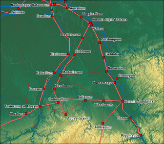
Sablones was a Roman settlement in the province of Germania Inferior, probably near modern-day Kaldenkirchen in Germany, just across the border from Venlo in the Netherlands. The statio is mentioned in the Roman travel guide Antonine Itinerary (Itinerarium Antonini) between Meridacium and Mediolanum and was located on the Roman road from Coriovallum (Heerlen) to Colonia Ulpia Traiana (Xanten).

<span class="mw-page-title-main">Via XVIII</span> Roman road

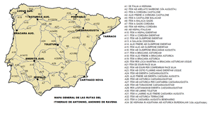
The Via Nova or Via XVIII in the Antonine Itinerary is a Roman road which linked the cities of Bracara Augusta and Asturica Augusta, with a length of about 210 roman miles.

An ancient Roman statio was a stopping place on a Roman road for travellers looking for shelter for the night and a change of horses. The name of the statio was sometimes a town or city with suitable accommodation, such as inns, and sometimes a dedicated building between larger settlements. They often included thermal baths in the facilities.

References

Citations

  1. 1 2 Wikisource-logo.svg One or more of the preceding sentences incorporates text from a publication now in the public domain :  Chisholm, Hugh, ed. (1911). "Antonini Itinerarium". Encyclopædia Britannica . Vol. 2 (11th ed.). Cambridge University Press. p. 148.
  2. Rivet, A. L. F.; Jackson, Kenneth (1970). "The British Section of the Antonine Itinerary". Britannia. 1: 34–82. doi:10.2307/525833. JSTOR   525833. S2CID   162217811.
  3. 1 2 Öberg (2023), p. 5.
  4. Parthey & Pinder 1848 :232–33 in Britannia
  5. 1 2 Codrington 1918, In Roman Roads in Britain
  6. = milia plus minus
  7. Roman numerals
  8. Parthey & Pinder 1848 :233 in Britannia
  9. Redmonds, George (2004), Names and History: People, Places and Things, Hambledon & London, pp.  65–68, ISBN   978-1-85285-426-3 A Major Place-Name Ignored
  10. Reynolds 1799 Iter Britanniarum
  11. Dyer 1816 Vulgar Errors, Ancient and Modern
  12. For most Roman roads in Hispania, see Gonzalo Arias. "El Miliario Extravagante". Archived from the original on 2011-07-25. Retrieved 2012-08-27.. Cf. also his Grammar in the Antonine Itinerary: A Challenge to British Archaeologists (available in only a few libraries).
  13. Cf. Rodwell, "Milestones, Civic Territories and the Antonine Itinerary", 6 Britannia 76-101 (1975).

Bibliography