Cunetio was a large walled town in a valley of the River Kennet in modern-day Wiltshire, England. The settlement was occupied from the 2nd century CE by Romano-British people until the post-Roman period, and was abandoned in the early 5th century. Its site is near the village of Mildenhall, about 1+1⁄2 miles (2.4km) east of the market town of Marlborough.
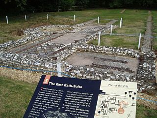
The entire town lay undiscovered until it was identified from aerial photos in the 1940s. Archaeological excavations have revealed that the town was a substantial urban area defended by large masonry walls. Artefacts recovered from the site include kitchenware, personal effects, and two hoards of Roman coinage.
The Cunetio site has been known since the 19th century, when local antiquarians conducted sporadic excavations. The full scale and importance of the site, however, was identified from aerial photos of crop marks taken in 1940, and the site has been sporadically excavated since the 1950s alongside the continuation of aerial photography to further map the site.[1] In the 1960s, a small coin hoard was found, followed in 1978 by the much larger Cunetio Hoard of over 55,000 coins. The site was dug and geophysically surveyed in 2009 by Channel 4's archaeological television programme Time Team, which found many more coins and other objects.[2]
The town grew around a mansio that had been built near the crossing of two Roman roads: the east–west road (Margary 53) from Speen in Berkshire to Aquae Sulis (Bath), and the south-east to north road (43) from Winchester to Wanborough.[3][4] As the town grew, it developed a regular grid of streets and stone buildings on its eastern side but retained less regular and substantial structures in the west part. The settlement's original defences were earthworks and an outer ditch; in the 4th century CE, these were replaced by massive stone walls 4m (13ft) wide, a large western gateway, and 17 semi-octagonal, external wall-towers.
The masonry walls ran inside and parallel with the original defences on the east side but outside of them on the south and west sides. The stone towers were approximately every 36.7m (120ft) apart. Excavations of the west gate show it was flanked by two towers and possibly had a set of iron-gates similar to a portcullis, because grooves were found in the remains of the towers' footings.
Archaeological examinations of the site do not reveal why Cunetio deserved so much expenditure on upgrading its defences, an act that was a rare occurrence for inland Britannia at the time, when most Roman military engineering projects were focused on the Saxon Shore forts. Two theories have been suggested: first that the town was being converted into a Legionary fortress to re-establish Roman authority in this part of the province of Britannia. Second, that the improvement work was being orchestrated by an ambitious local British governor – the type of man who would, within a generation or so, be setting himself up as a war-lord or regional chieftain. Interpretation therefore swings between the Roman Empire re-establishing its authority after various rebellions and uprisings, or Roman authority breaking down.[5]
In the 3rd century, the town was a prosperous settlement,[6] and by the start of the 4th, it had become a hub of villas.[7] It has also been suggested that the town was reorganised as a centre of taxation, administration, and military functions later in the 4th century AD, coinciding with the addition of the defensive stone wall.[8] However, the Roman withdrawal from Britain c. 410 caused Cunetio to rapidly decline in importance, until it was completely abandoned.[9][10]
Notes
↑ Corney, M. 1997. The Origins and Development of the 'Small Town' of Cunetio, Mildenhall, Wiltshire. Britannia. 28. 337-350.
↑ Hostetter, Eric; Howe, Thomas Noble; Allison, E. P. (1997). The Romano-British Villa at Castle Copse, Great Bedwyn. Indiana University Press. p.45. ISBN978-0-253-32802-1.
↑ Bland, Roger; Besly, Edward; Burnett, Andrew (2019). The Cunetio and Normanby Hoards: Roger Bland, Edward Besly and Andrew Burnett, with notes to aid identification by Sam Moorhead. Spink Books. p.173. ISBN978-1-912667-33-8.
↑ Pohl, Walter; Gantner, Clemens; Grifoni, Cinzia; Pollheimer-Mohaupt, Marianne (2018). Transformations of Romanness: Early Medieval Regions and Identities. Walter de Gruyter GmbH & Co KG. ISBN978-3-11-059756-1.
↑ Davison, Steve (1 June 2015). Walking in the North Wessex Downs. Cicerone Press Limited. ISBN978-1-78362-212-2.
Calleva Atrebatum was an Iron Age settlement, as capital of the Atrebates tribe. It then became a walled town in the Roman province of Britannia at a major crossroads in the Roman roads of Britain.
Camulodunum, the Ancient Roman name for what is now Colchester in Essex, was an important town in Roman Britain, and the first capital of the province. It is claimed to be the oldest town in Britain. Originally the site of the Brythonic-Celtic oppidum of Camulodunon, capital of the Trinovantes and later the Catuvellauni tribes, it was first mentioned by name on coinage minted by the chieftain Tasciovanus some time between 20 and 10 BC. The Roman town began life as a Roman legionary base constructed in the AD 40s on the site of the Brythonic-Celtic fortress following its conquest by the Emperor Claudius. After the early town was destroyed during the Iceni rebellion in AD 60/61, it was rebuilt, reaching its zenith in the 2nd and 3rd centuries. During this time it was known by its official name Colonia Claudia Victricensis, often shortened to Colonia Victricensis, and as Camulodunum, a Latinised version of its original Brythonic name. The town was home to a large classical temple, two theatres, several Romano-British temples, Britain's only known chariot circus, Britain's first town walls, several large cemeteries and over 50 known mosaics and tessellated pavements. It may have reached a population of 30,000 at its height. It was not until the late 18th century that historians realised that Colchester's physical Brythonic and Roman remains were the city mentioned in ancient literature as "Camulodunum".
Mildenhall is a village and civil parish in the Kennet Valley in Wiltshire, England, about 1 mile (1.6 km) east of the market town of Marlborough. The parish contains three communities – the village of Mildenhall, and the hamlets of Poulton and Stitchcombe.
Stane Street is the modern name of the 91 km-long (57 mi) Roman road in southern England that linked Londinium (London) to Noviomagus Reginorum (Chichester). The exact date of construction is uncertain; however, on the basis of archaeological artefacts discovered along the route, it was in use by 70 AD and may have been built in the first decade of the Roman occupation of Britain.
54.9894°N 2.6023°W
52°20′N1°11′E
53°15′32″N1°54′54″W
Venta Silurum was a town in the Roman province of Britannia or Britain. Today it consists of remains in the village of Caerwent in Monmouthshire, south east Wales. Much of it has been archaeologically excavated and is on display to the public.
Durocornovium was a Roman town in Britain, situated on the Roman road between Corinium Dobunnorum (Cirencester) and Calleva Atrebatum (Silchester). In many ways Durocornovium was a typical small Roman town.
Rockbourne Roman Villa is a Roman courtyard villa excavated and put on public display in the village of Rockbourne in the English county of Hampshire. The villa was discovered in 1942 by a local farmer and excavated by A. T. Morley Hewitt over the next thirty years.
Littlecote Roman Villa is an extensive and exceptional Roman villa, with associated religious complex, at Littlecote Park in Ramsbury, Wiltshire. It has been excavated and is on display to the public in the grounds of the estate.
Port Way is an ancient road in southern England which ran from Calleva Atrebatum in a south-westerly direction to Sorbiodunum. Often associated with the Roman Empire, the road may have predated the Roman occupation of Britain.
54.9784°N 2.03316°W
Regulbium was the name of an ancient Roman fort of the Saxon Shore in the vicinity of the modern English resort of Reculver in Kent. Its name derives from the local Brythonic language, meaning "great headland" (*Rogulbion).
The Cunetio Hoard, also known as the Mildenhall Hoard, is the largest hoard of Roman coins found in Britain. It was discovered in 1978 at the site of the Roman town of Cunetio, near modern-day Mildenhall, Wiltshire, and consisted of 54,951 low value coins. The coins were contained in a large pot and a lead container. The coins are now in the British Museum and the pot is on display at the Wiltshire Museum in Devizes.
The Stanchester Hoard is a hoard of 1,166 Roman coins dating from the fourth to early fifth century found in 2000 at Wilcot, in the Vale of Pewsey, Wiltshire, England. The find was considered important because of the large quantity of unclipped silver coins contained within. It was also the latest dated example of Roman coins found in Wiltshire.
A Romano-Celtic temple is a sub-class of Roman temple found in the north-western provinces of the Roman Empire. Many may have had roots in the late Iron Age either in direct relation to pre-Roman structures or on sites with pre-Roman activity.
Over Burrow Roman Fort is the modern name given to a former Roman fort at Over Burrow, Lancashire in North West England. Today it is the site of the 18th-century country house Burrow Hall. The first castra is thought to have been founded in the first century AD within the Roman province of Britannia.
This page is based on this Wikipedia article Text is available under the CC BY-SA 4.0 license; additional terms may apply. Images, videos and audio are available under their respective licenses.