
Ambrosius Aurelianus was a war leader of the Romano-British who won an important battle against the Anglo-Saxons in the 5th century, according to Gildas. He also appeared independently in the legends of the Britons, beginning with the 9th-century Historia Brittonum. Eventually, he was transformed by Geoffrey of Monmouth into the uncle of King Arthur, the brother of Arthur's father Uther Pendragon, as a ruler who precedes and predeceases them both. He also appears as a young prophet who meets the tyrant Vortigern; in this guise, he was later transformed into the wizard Merlin.

Merlin is a mythical figure prominently featured in the legend of King Arthur and best known as a magician, with several other main roles. The familiar depiction of Merlin, based on an amalgamation of historic and legendary figures, was introduced by the 12th-century British pseudo-historical author Geoffrey of Monmouth and then built on by the French poet Robert de Boron and their prose successors in the 13th century.

Verulamium was a town in Roman Britain. It was sited southwest of the modern city of St Albans in Hertfordshire, England. A large portion of the Roman city remains unexcavated, being now park and agricultural land, though much has been built upon. The major ancient Roman route Watling Street passed through the city. Much of the site and its environs is now a scheduled monument.
Caer is a placename element in Welsh meaning "stronghold", "fortress", or "citadel", roughly equivalent to an Old English suffix (-ceaster) now variously written as -caster, -cester, and -chester.

There are many Roman sites in Great Britain that are open to the public. There are also many sites that do not require special access, including Roman roads, and sites that have not been uncovered.

Carmarthenshire is a county in the south-west of Wales. The three largest towns are Llanelli, Carmarthen and Ammanford. Carmarthen is the county town and administrative centre. The county is known as the "Garden of Wales" and is also home to the National Botanic Garden of Wales.

Dinas Emrys is a rocky and wooded hillock near Beddgelert in Gwynedd, north-west Wales. Rising some 76 m (250 ft) above the floor of the Glaslyn river valley, it overlooks the southern end of Llyn Dinas in Snowdonia.

Carmarthen is the county town of Carmarthenshire and a community in Wales, lying on the River Towy 8 miles (13 km) north of its estuary in Carmarthen Bay. The population was 14,185 in 2011, down from 15,854 in 2001, but gauged at 16,285 in 2019. It has a claim to be the oldest town in Wales – Old Carmarthen and New Carmarthen became one borough in 1546. It was the most populous borough in Wales in the 16th–18th centuries, described by William Camden as "chief citie of the country". Growth stagnated by the mid-19th century as new settlements developed in the South Wales Coalfield.

The Cornovīī were a Celtic people of the Iron Age and Roman Britain, who lived principally in the modern English counties of Cheshire, Shropshire, north Staffordshire, north Herefordshire and eastern parts of the Welsh counties of Flintshire, Powys and Wrexham. Their capital in pre-Roman times was probably a hillfort on the Wrekin. Ptolemy's 2nd-century Geography names two of their towns: Deva Victrix (Chester) and Viroconium Cornoviorum (Wroxeter), which became their capital under Roman rule.

The Demetae were a Celtic people of Iron Age and Roman period, who inhabited modern Pembrokeshire and Carmarthenshire in south-west Wales. The tribe also gave their name to the medieval Kingdom of Dyfed, the modern area and county of Dyfed and the distinct dialect of Welsh spoken in modern south-west Wales, Dyfedeg.
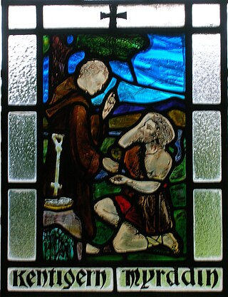
Myrddin Wyllt is a figure in medieval Welsh legend. In Middle Welsh poetry he is accounted a chief bard, the speaker of several poems in The Black Book of Carmarthen and The Red Book of Hergest. He is called Wyllt—"the Wild"—by Elis Gruffydd, and elsewhere Myrddin Emrys ("Ambrosius"), Merlinus Caledonensis or Merlin Sylvestris("of the woods"). Myrddin Wylt was born in 540 CE.
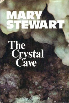
The Crystal Cave is a 1970 fantasy novel by Mary Stewart. The first in a quintet of novels covering the Arthurian legend, it is followed by The Hollow Hills.

Segontium is a Roman fort on the outskirts of Caernarfon in Gwynedd, North Wales. The fort, which survived until the end of the Roman occupation of Britain, was garrisoned by Roman auxiliaries from present-day Belgium and Germany. It was the most important military base and administrative centre in this part of Britain.

Arthuret is a civil parish in the Carlisle district of Cumbria, England. According to the 2001 census it had a population of 2,434, increasing to 2,471 at the 2011 Census. The parish includes the town of Longtown and the village of Easton. It is bounded by the River Esk to the west and the River Lyne to the south.

Sarn Helen refers to several stretches of Roman road in Wales. The 160-mile (260 km) route, which follows a meandering course through central Wales, connects Aberconwy in the north with Carmarthen in the west. Despite its length, academic debate continues as to the precise course of the Roman road. Many sections are now used by the modern road network while other parts are still traceable. However, there are sizeable stretches that have been lost and are unidentifiable.
Luguvalium was a Roman town in northern Britain in antiquity. It was located within present-day Carlisle, Cumbria, and may have been the capital of the 4th-century province of Valentia.

The Roman era in the area of modern Wales began in 48 AD, with a military invasion by the imperial governor of Roman Britain. The conquest was completed by 78 AD, and Roman rule endured until the region was abandoned in 383 AD.

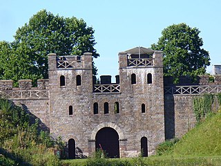
Caerleon Roman Fortress and Baths encompass the archaeological ruins and sites of the Legionary Fortress of Isca Augusta spread across the town of Caerleon, near the city of Newport, South Wales. Notable for being one of only three permanent legionary fortresses from Roman Britain, Caerleon has provided a unique opportunity to study the archaeology of a Roman Legionary fortress, less affected by the medieval and subsequent urban activity of most such fortresses. Having attracted the attention of eminent archaeologists throughout the 20th century it now has four major public archaeological venues, including the museum run by Cadw, called 'Caerleon Roman Fortress and Baths', featuring the excavated fortress bath-house. Also open to the public is the most complete excavated amphitheatre in Britain, a series of barracks and the National Roman Legion Museum. The fortress and its surrounding civil settlement have been the subject of continuing major archaeological investigations into the 21st century.

The Battle of Guoloph, also known as the Battle of Wallop, took place in the 5th century. Various dates have been put forward: 440 AD by Alfred Anscombe, 437 AD according to John Morris, and 458 by Nikolai Tolstoy. It took place at what is now Nether Wallop, 15 kilometers southeast of Amesbury, in the district of Test Valley, northeastern Hampshire. The battle was an internal conflict between the rival Britonnic forces of Ambrosius Aurelianus and Vortigern (Vitalinus).

