
The Chattahoochee River forms the southern half of the Alabama and Georgia border, as well as a portion of the Florida - Georgia border. It is a tributary of the Apalachicola River, a relatively short river formed by the confluence of the Chattahoochee and Flint rivers and emptying from Florida into Apalachicola Bay in the Gulf of Mexico. The Chattahoochee River is about 430 miles (690 km) long. The Chattahoochee, Flint, and Apalachicola rivers together make up the Apalachicola–Chattahoochee–Flint River Basin. The Chattahoochee makes up the largest part of the ACF's drainage basin.

Fort Ouiatenon, built in 1717, was the first fortified European settlement in what is now called Indiana. It was a palisade stockade with log blockhouse used as a French trading post on the Wabash River located approximately three miles southwest of modern-day West Lafayette. The name 'Ouiatenon' is a French rendering of the name in the Wea language, waayaahtanonki, meaning 'place of the whirlpool'. It was one of three French forts built during the 18th century in what was then New France, later the Northwest Territory and today the state of Indiana, the other two being Fort Miami and Fort Vincennes. A substantial French settlement grew up around the fort in the mid-18th century. It was ceded to the British and abandoned after the French and Indian war. Later, it passed into Indian hands and was destroyed in 1791 by American militia during the Northwest Indian War. It was never a U.S. fort. The original site was rediscovered in the 1960s; the archaeological site was listed on the National Register of Historical Places in 1970, and was designated a National Historic Landmark in 2021.

Prospect Bluff Historic Sites is located in Franklin County, Florida, on the Apalachicola River, 6 miles (9.7 km) SW of Sumatra, Florida. The site contains the ruins of two forts

Ocmulgee Mounds National Historical Park in present-day Macon, Georgia, United States preserves traces of over ten millennia of culture from the Native Americans in the Southeastern Woodlands. Its chief remains are major earthworks built before 1000 CE by the South Appalachian Mississippian culture These include the Great Temple and other ceremonial mounds, a burial mound, and defensive trenches. They represented highly skilled engineering techniques and soil knowledge, and the organization of many laborers. The site has evidence of "17,000 years of continuous human habitation." The 3,336-acre (13.50 km2) park is located on the east bank of the Ocmulgee River. Present-day Macon, Georgia developed around the site after the United States built Fort Benjamin Hawkins nearby in 1806 to support trading with Native Americans.

Fort Hawkins was a fort built in 1806–1810 in the historic Creek Nation by the United States government under President Thomas Jefferson and used until 1824. Built in what is now Georgia at the Fall Line on the east side of the Ocmulgee River, the fort overlooked the sacred ancient earthwork mounds of the Ocmulgee Old Fields, now known as the Ocmulgee Mounds National Historical Park, and the Lower Creek Pathway. A trading settlement and later the city of Macon, Georgia, developed in the area prior to the construction of the fort, with Scottish fur traders being in the area as early as the 1650s. Later, the fort would become important to the Creek Nation, the United States, and the state of Georgia for economic, military, and political reasons.

San Marcos de Apalache Historic State Park is a Florida State Park in Wakulla County, Florida organized around the historic site of a Spanish colonial fort, which was used by succeeding nations that controlled the area. The Spanish first built wooden buildings and a stockade in the late 17th and early 18th centuries here, which were destroyed by a hurricane.

Los Adaes was the capital of Tejas on the northeastern frontier of New Spain from 1729 to 1770. It included a mission, San Miguel de Cuellar de los Adaes, and a presidio, Nuestra Señora del Pilar de Los Adaes. The name Adaes represents the indigenous Adai people, who were to be served by the mission.
The Yamasee War was a conflict fought in South Carolina from 1715–1717 between British settlers from the Province of Carolina and the Yamasee and a number of other allied Native American peoples, including the Muscogee, Cherokee, Catawba, Apalachee, Apalachicola, Yuchi, Savannah River Shawnee, Congaree, Waxhaw, Pee Dee, Cape Fear, Cheraw, and others. Some of the Native American groups played a minor role, while others launched attacks throughout South Carolina in an attempt to destroy the colony.
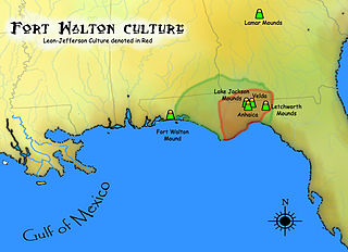
The Fort Walton culture is the term used by archaeologists for a late prehistoric Native American archaeological culture that flourished in southeastern North America from approximately 1200~1500 CE and is associated with the historic Apalachee people.

Mission San Luis de Apalachee was a Spanish Franciscan mission built in 1633 in the Florida Panhandle, two miles west of the present-day Florida Capitol Building in Tallahassee, Florida. It was located in the descendent settlement of Anhaica capital of Apalachee Province. The mission was part of Spain's effort to colonize the Florida Peninsula and to convert the Timucuan and Apalachee Indians to Christianity. The mission lasted until 1704 when it was evacuated and destroyed to prevent its use by an approaching militia of Creek Indians and South Carolinians.
The Cayson Mound and Village Site (8CA3) is a prehistoric archaeological site located near Blountstown, Florida. It is located three miles southeast of Blountstown, on the Apalachicola River. The site was occupied by peoples of the Fort Walton Culture. On March 15, 1976, it was added to the U.S. National Register of Historic Places.
The Yon Mound and Village Site (8LI2) is a prehistoric archaeological site located two miles west of Bristol, Florida on the east bank of the Apalachicola River. The site was occupied by peoples of the Fort Walton Culture. On December 15, 1978, it was added to the U.S. National Register of Historic Places as reference number 78000952.
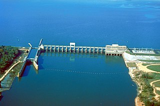
Lake Seminole is a reservoir located in the southwest corner of Georgia along its border with Florida, maintained by the U.S. Army Corps of Engineers. The Chattahoochee and Flint rivers join in the lake, before flowing from the Jim Woodruff Lock and Dam, which impounds the lake, as the Apalachicola River. The lake contains 37,500 acres (152 km2) of water, and has a shoreline of 376 mi (605 km). The fish in Lake Seminole include largemouth bass, crappie, chain pickerel, catfish, striped bass and other species. American alligators, snakes and various waterfowl are also present in the lake, which is known for its goose hunting.

Holy Trinity is an unincorporated community in Russell County, Alabama, United States. Its elevation is 312 feet (95 m), and it is located at 32°13′21″N85°0′19″W. A post office was located in the community, but it has been closed. It is about 20 miles south of Columbus, Georgia, on State Route 165. It is the location of Apalachicola Fort Site, a National Historic Landmark.

Fort Mitchell Historic Site is a park and an archaeological site in Fort Mitchell, Alabama, that was declared a National Historic Landmark in 1990. The park features a reconstruction of the 1813 stockade fort that was an important United States military post in the Creek War, a museum with exhibits about the fort's history, and a collection of historic carriages, a restored 19th-century log home, and a visitor center.

Yuchi Town Site, or Yuchi Town, is a late prehistoric and historic era archaeological site showing occupation of both the Apalachicola and of Yuchi tribes. The site is located in a remote area of Fort Benning, Russell County, Alabama. The Yuchi Town Site is an example of historic Native American cultures adopting various strategies to maintain their cultural integrity in the face of European colonization and the expansion of the United States. It was declared a National Historic Landmark in 1996.
The Battle of Flint River was a failed attack by Spanish and Apalachee Indian forces against Creek Indians in October 1702 in what is now the state of Georgia. The battle was a major element in ongoing frontier hostilities between English traders from the Province of Carolina and Spanish Florida, and it was a prelude to more organized military actions of Queen Anne's War.
Diego de Quiroga y Losada was the acting Governor of Spanish Florida 1687–1693. His administration was mainly concerned with building fortifications, including the Castillo de San Marcos, which his predecessors began to defend La Florida against British and French attacks by land and water.
Fort Scott was built in 1816 on the west bank of the Flint River, where it joins the Chattahoochee River to form the Apalachicola, in the southwest corner of Georgia. It was named for Lt. Richard W. Scott, killed in the Scott Massacre of 1817 and never known to have visited the Fort. The need for a fort became evident during the War of 1812, when the British identified this undefended United States border, and in 1814 built two forts on the Apalachicola River, into which the Flint River flows: a strong fort at Prospect Bluff and a smaller one, Nicolls' Outpost, at the river juncture. This was in Spanish Florida, but Spain had neither the resources nor the inclination to do anything about this fort in a location to them remote.


