Related Research Articles

Hermel is a town in Baalbek-Hermel Governorate, Lebanon. It is the capital of Hermel District. Hermel is home to a Lebanese Red Cross First Aid Center. Hermel's inhabitants are predominantly Shia Muslims.

Qaa, El Qaa, Al Qaa, Qaa Baalbek or Masharih al-Qaa is a town in Baalbek-Hermel Governorate, Lebanon. A 2010 report stated that population of the settlement was 500, all Lebanese Maronites

Joub Jannine is located in the Beqaa Valley in Lebanon.
Jdeideh, also Jdayde, Jdaideh and Jdeidet el-Matn, is a coastal municipality and the administrative capital of the Matn District in the Mount Lebanon Governorate.

Aadloun, Adloun or Adlun is a coastal town in South Lebanon, 17 kilometres (11 mi) south of Sidon famous for its cultivation of watermelons. It is also the site of a Phoenician necropolis and prehistoric caves where four archaeological sites have been discovered and dated to the Stone Age. The evidence of human occupation of Abri Zumoffen has been dated as far back as 71,000 BCE with occupation of Bezez Cave dating back even further into the earlier Middle Paleolithic.

Archaeology of Lebanon includes thousands of years of history ranging from Lower Palaeolithic, Phoenician, Roman, Arab, Ottoman, and Crusades periods.
The Sands of Beirut were a series of archaeological sites located on the coastline south of Beirut in Lebanon.

Qaraoun is a Lebanese village, 85 km from Beirut, known for its Lake Qaraoun in the Beqaa Valley formed by the El Wauroun Dam built in 1959. It is an ecologically fragile zone in the Western Beqaa District. The village lies about 800 m above sea level. The dam is located nearby on the Litani River.
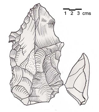
Heavy Neolithic is a style of large stone and flint tools associated primarily with the Qaraoun culture in the Beqaa Valley, Lebanon, dating to the Epipaleolithic or early Pre-Pottery Neolithic at the end of the Stone Age. The type site for the Qaraoun culture is Qaraoun II.
Shepherd Neolithic is a name given by archaeologists to a style of small flint tools from the Hermel plains in the north Beqaa Valley, Lebanon. The Shepherd Neolithic industry has been insufficiently studied and was provisionally named based on a limited typology collected by Jesuit archaeologist "Père" Henri Fleisch. Lorraine Copeland and Peter J. Wescombe suggested it was possibly "of quite late date".
Jebel Aabeby is an archaeological site approximately 2 kilometres (1.2 mi) southeast of Sidon, to the west of the road north to Qraye in Lebanon. The site is on a hill where a number of Cedar trees surround the Mar Elias monastery on the western side of the summit. A Heavy Neolithic assemblage of flint tools made by the Qaraoun culture was collected from some Olive terraces bordering on the road and from an area above them that was disturbed in the construction of a trackway. The flint was of a brown, Nummulitic, Eocene type, some having been patinated to white while others were found fresh. Several broad blades were found along with heavy scrapers on flakes, massive cores, rabots, racloirs and a few smaller scrapers. The material now stored in the Museum of Lebanese Prehistory was studied by Henri Fleisch, who concluded that the site was likely used as a prehistoric factory.
Dekwaneh is a suburb north of Beirut in the Matn District of the Mount Lebanon Governorate, Lebanon. The population is predominantly Maronite Christian. Tel al-Zaatar, an UNRWA administered Palestinian refugee camp housing approximately 50,000-60,000 refugees, and the site of the Tel al-Zaatar massacre were located on the outskirts of the town.
Ourrouar is a series of archaeological sites approximately 8.5 kilometres (5.3 mi) south southeast of Beirut, Lebanon. It is near Hadeth south on the north side of the Nahr Ghedir.
Amlaq Qatih or Amlaq el Qatih is a Heavy Neolithic archaeological site of the Qaraoun culture that is located 2.5 kilometres (1.6 mi) northwest of Baaloul, 5 kilometres (3.1 mi) north of Qaraoun, Lebanon.
Khallet Michte is a Heavy Neolithic archaeological site of the Qaraoun culture located in the Caza of Bint Jbeil in the Nabatiye Governorate in Lebanon. The two sites Khallet Michte I and Khallet Michte II are located in adjacent wadis on south facing slopes between a track and the main road between Bint Jbeil and Ain Ebel. They were found by Henri Fleisch and noted to contain both Heavy Neolithic and Acheulean flint tools which are now in the collection of the Museum of Lebanese Prehistory at the Saint Joseph University.
Baidar ech Chamout, Baïdar ech Chamoût or Beidar Chamout is a small village located 3 kilometres (1.9 mi) northeast of Machgara in the Western Beqaa District of Beqaa Governorate in Lebanon.

Flaoui or Fleywe or Flaoueh is a small village located 17 kilometres (11 mi) northwest of Baalbek, Lebanon in Baalbek District, Baalbek-Hermel Governorate, Lebanon. It is located near the north–south road that runs from Bodai to Chlifa.
Khallet el Hamra or Khallet Hamra is a ravine or wadi joining the larger Wadi Yaroun located 1 kilometre (0.62 mi) southeast of Ain Ebelin the Bint Jbeil District of Nabatieh Governorate in Lebanon.

Tell Ain el Meten is a tell in the area of El Meten in the Rashaya District, south-eastern portion of the Bekaa Governorate of the Republic of Lebanon. It is located opposite the village of Sawiri.
Maqne or Maakne is a town and municipality in Baalbek District, Baalbek-Hermel Governorate, Lebanon.
References
- ↑ Moore, A.M.T. (1978). The Neolithic of the Levant. Oxford University, Unpublished Ph.D. Thesis. pp. 436–442.
- 1 2 3 L. Copeland; P. Wescombe (1966). Inventory of Stone-Age Sites in Lebanon: North, South and East-Central Lebanon, p. 23. Impr. Catholique. Retrieved 29 August 2011.