Arroyo Grande, California

Last updated

Arroyo Grande, California
View of irrigated fields and town structures near Arroyo Grande, along California Highway 1, south of Pismo Beach, California LCCN2013631457 (cropped).tif
2012-04-06 04-08 Big Sur 130 Arroyo Grande (7089817179).jpg
ArroyoGrandeVillage2012 (cropped).jpg
Top: view of Arroyo Grande; bottom: downtown.
Flag of Arroyo Grande, California.jpg
Arroyo Grande CA seal.gif
San Luis Obispo County California Incorporated and Unincorporated areas Arroyo Grande Highlighted 0602868.svg
Location of Arroyo Grande in San Luis Obispo County, California
Coordinates: 35°7′15″N120°35′12″W / 35.12083°N 120.58667°W / 35.12083; -120.58667
Country United States
State California
County San Luis Obispo
Incorporated July 10, 1911 [1]
Named for Big Dry Creek
Government
  Type Council–manager [2]
  BodyArroyo Grande City Council
   Mayor Caren Ray Russom [3]
   City Manager Matthew Downing [4]
   Assemblymember Jasmeet Bains (D) [5]
   State Senator John Laird (D) [5]
Area
[6]
  Total5.94 sq mi (15.38 km2)
  Land5.94 sq mi (15.38 km2)
  Water0.00 sq mi (0.00 km2)  0%
Elevation
[7]
118 ft (36 m)
Population
 (2020)
  Total18,441
  Density3,104.55/sq mi (1,199.02/km2)
Time zone UTC−8 (Pacific (PST))
  Summer (DST) UTC−7 (PDT)
ZIP Codes
93420-93421 [8]
Area code 805
FIPS code 06-02868 [9]
GNIS feature IDs 1660271, 2409734
Website www.arroyogrande.org

Arroyo Grande (Spanish for "Big Creek") is a city in San Luis Obispo County, California, United States. [10] The population was 18,441 as of the 2020 census, up from 17,252 as of the 2010 Census.

Contents

History

In 1862, the San Luis Obispo Board of Supervisors established the township of Arroyo Grande. Businesses developed along a road called Branch Street to serve local agriculture. A railroad depot was built in 1882. The city of Arroyo Grande was incorporated on July 10, 1911.

Arroyo Grande experienced rapid growth in the 1970s and 1980s, partially due to the expansion of the wastewater treatment plant, under an EPA Clean Water Grant, that removed a growth constraint. This federal grant program required preparation of an Environmental Impact Report, [11] which provided much of the initial environmental database for Arroyo Grande.
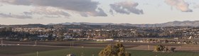
Geography

Arroyo Grande is a small coastal town with historic, suburban, and rural elements located at 35°7′15″N120°35′12″W / 35.12083°N 120.58667°W / 35.12083; -120.58667 (35.120878, -120.586799).

Arroyo Grande is located in a coastal ecosystem within the California Floristic Province, and the native habitats include coast live oak woodland, central coastal scrub, willow and mixed riparian along Arroyo Grande Creek and numerous tributaries, native bunch-grass grassland, coastal prairie, dunes and intertidal zone, and non-native and agricultural areas.

According to the United States Census Bureau, the city has a total area of 5.8 square miles (15 km2), all of it land.

Climate

Arroyo Grande has a Temperate-Mediterranean climate (Köppen climate classification Csb).

Climate data for Arroyo Grande, California
MonthJanFebMarAprMayJunJulAugSepOctNovDecYear
Record high °F (°C)85
(29)
90
(32)
90
(32)
101
(38)
100
(38)
99
(37)
104
(40)
108
(42)
100
(38)
99
(37)
91
(33)
92
(33)
108
(42)
Mean daily maximum °F (°C)60
(16)
61
(16)
62
(17)
64
(18)
65
(18)
66
(19)
66
(19)
67
(19)
68
(20)
67
(19)
65
(18)
60
(16)
64
(18)
Mean daily minimum °F (°C)45
(7)
46
(8)
47
(8)
48
(9)
50
(10)
52
(11)
54
(12)
55
(13)
54
(12)
52
(11)
48
(9)
44
(7)
50
(10)
Record low °F (°C)24
(−4)
28
(−2)
23
(−5)
31
(−1)
30
(−1)
37
(3)
38
(3)
39
(4)
35
(2)
32
(0)
29
(−2)
24
(−4)
23
(−5)
Average rainfall inches (mm)3.04
(77)
3.96
(101)
3.04
(77)
1.14
(29)
0.41
(10)
0.07
(1.8)
0.03
(0.76)
0.07
(1.8)
0.14
(3.6)
0.87
(22)
1.52
(39)
2.73
(69)
17.02
(432)
Source: http://www.weather.com/weather/wxclimatology/monthly/graph/USCA0045

Demographics

Historical population
CensusPop.Note
1890 466
1920 760
1930 89217.4%
1940 1,09022.2%
1950 1,72358.1%
1960 3,29191.0%
1970 7,454126.5%
1980 11,29051.5%
1990 14,37827.4%
2000 15,85110.2%
2010 17,2528.8%
2020 18,4416.9%
U.S. Decennial Census [12]

2010

IOOF building I.O.O.F. - Arroyo Grande, CA.JPG
IOOF building
Shops in downtown Arroyo Grande Arroyo Grande 22.jpg
Shops in downtown Arroyo Grande

At the 2010 census Arroyo Grande had a population of 17,252. The population density was 2,956.5 inhabitants per square mile (1,141.5/km2). The racial makeup of Arroyo Grande was 14,710 (85.3%) White, 156 (0.9%) African American, 125 (0.7%) Native American, 595 (3.4%) Asian, 14 (0.1%) Pacific Islander, 856 (5.0%) from other races, and 796 (4.6%) from two or more races. Hispanic or Latino of any race were 2,707 persons (15.7%). [13]

The census reported that 17,078 people (99.0% of the population) lived in households, 62 (0.4%) lived in non-institutionalized group quarters, and 112 (0.6%) were institutionalized.

There were 7,087 households, 2,027 (28.6%) had children under the age of 18 living in them, 3,741 (52.8%) were opposite-sex married couples living together, 653 (9.2%) had a female householder with no husband present, 275 (3.9%) had a male householder with no wife present. There were 346 (4.9%) unmarried opposite-sex partnerships, and 42 (0.6%) same-sex married couples or partnerships. 1,968 households (27.8%) were one person and 1,017 (14.4%) had someone living alone who was 65 or older. The average household size was 2.41. There were 4,669 families (65.9% of households); the average family size was 2.93.

The age distribution was 3,633 people (21.1%) under the age of 18, 1,193 people (6.9%) aged 18 to 24, 3,704 people (21.5%) aged 25 to 44, 5,229 people (30.3%) aged 45 to 64, and 3,493 people (20.2%) who were 65 or older. The median age was 45.4 years. For every 100 females, there were 92.6 males. For every 100 females age 18 and over, there were 88.4 males.

There were 7,628 housing units at an average density of 1,307.2 per square mile, of the occupied units 4,686 (66.1%) were owner-occupied and 2,401 (33.9%) were rented. The homeowner vacancy rate was 1.9%; the rental vacancy rate was 4.0%. 11,345 people (65.8% of the population) lived in owner-occupied housing units and 5,733 people (33.2%) lived in rental housing units.

2000

Pedestrian bridge in Arroyo Grande Arroyo Grande 12.jpg
Pedestrian bridge in Arroyo Grande

At the 2000 census, there were 15,851 people in 6,478 households, including 4,353 families, in the city. The population density was 2,795.3 inhabitants per square mile (1,079.3/km2). There were 6,750 housing units at an average density of 1,190.3 per square mile (459.6/km2). The racial makeup of the city was 88.45% White, 0.62% African American, 0.45% Native American, 3.08% Asian, 0.18% Pacific Islander, 3.77% from other races, and 3.45% from two or more races. Hispanic or Latino of any race were 11.17% of the population.

Of the 6,478 households 29.0% had children under the age of 18 living with them, 55.0% were married couples living together, 9.4% had a female householder with no husband present, and 32.8% were non-families. 27.3% of households were one person and 14.4% were one person aged 65 or older. The average household size was 2.41 and the average family size was 2.94.

The age distribution was 23.3% under the age of 18, 6.7% from 18 to 24, 25.1% from 25 to 44, 24.6% from 45 to 64, and 20.3% 65 or older. The median age was 42 years. For every 100 females, there were 88.9 males. For every 100 females age 18 and over, there were 84.5 males.

The median income for a household in the city was $48,236, and the median family income was $55,494. Males had a median income of $41,304 versus $30,688 for females. The per capita income for the city was $24,311. About 4.3% of families and 6.9% of the population were below the poverty line, including 6.8% of those under age 18 and 5.4% of those age 65 or over.

Government

Santa Manuela schoolhouse Arroyo Grande 16.jpg
Santa Manuela schoolhouse

In the California State Legislature, Arroyo Grande is in the 17th Senate District , represented by Democrat John Laird, and in the 30th Assembly District , represented by Democrat Dawn Addis. [14]

In the United States House of Representatives, Arroyo Grande is in California's 24th congressional district , represented by Democrat Salud Carbajal. [15]

Notable people

See also

Related Research Articles

<span class="mw-page-title-main">San Luis Obispo County, California</span> County in California, United States

San Luis Obispo County, officially the County of San Luis Obispo, is a county on the Central Coast of California. As of the 2020 census, the population was 282,424. The county seat is San Luis Obispo.

<span class="mw-page-title-main">Biggs, California</span> City in California, United States

Biggs is a city in Butte County, California, United States. The population was 1,707 at the 2010 census, down from 1,793 at the 2000 census. The 2018 population estimate is 1,724.

<span class="mw-page-title-main">Blue Lake, California</span> City in California, United States

Blue Lake is a city in Humboldt County, California, United States. Blue Lake is located on the Mad River in a deep valley, 16 miles (26 km) northeast of Eureka, at an elevation of 131 feet. Its population is 1,208 as of the 2020 census, down from 1,253 from the 2010 census.

<span class="mw-page-title-main">South San Gabriel, California</span> Census-designated place in California, United States

South San Gabriel is a census-designated place (CDP) in Los Angeles County, California, United States. The population was 8,070 at the 2010 census, up from 7,595 at the 2000 census.

<span class="mw-page-title-main">Boronda, California</span> Census-designated place in California, United States

Boronda is an unincorporated community and census-designated place (CDP) in Monterey County, California, United States. The population was 1,760 at the 2020 census. Boronda is located directly west of Salinas and is named after José Eusebio Boronda, a Californio ranchero, and located on the lands of his Rancho Rincón del Sanjón.

<span class="mw-page-title-main">North Tustin, California</span> Place in California, United States

North Tustin is an unincorporated community and census designated place (CDP) in Orange County, California. The population was 25,718 at the 2020 census, up from 24,917 in 2010. For statistical purposes, the United States Census Bureau has defined North Tustin as a census-designated place (CDP). It is both the largest CDP and largest unincorporated community in Orange County. The CDP's name was changed from Tustin Foothills in 2005. Located outside the city limits of Tustin, North Tustin has 92705 and 92780 ZIP Codes.

<span class="mw-page-title-main">El Cerrito, Riverside County, California</span> Census-designated place in Riverside County, California, United States

El Cerrito is a census-designated place (CDP) in Riverside County, California, United States. It is an unincorporated area mostly surrounded by the city of Corona. The population was 5,100 at the 2010 census, up from 4,590 at the 2000 census.

<span class="mw-page-title-main">Winchester, California</span> Census-designated place in California, United States

Winchester is a census-designated place (CDP) in Riverside County, California, USA. As of the 2010 census, the CDP had a total population of 2,534, up from 2,155 at the 2000 census.

<span class="mw-page-title-main">Atascadero, California</span> City in California, United States

Atascadero is a city in San Luis Obispo County, California, United States, located on U.S. Route 101. Atascadero is part of the San Luis Obispo-Paso Robles metropolitan statistical area, which encompasses the extents of the county. Atascadero is farther inland than most other cities in the county, and as a result, usually experiences warmer, drier summers, and cooler winters than other nearby cities such as San Luis Obispo and Pismo Beach. The main freeway through town is U.S. 101. The nearby State Routes 41 and 46 provide access to the Pacific Coast and the Central Valley of California.

<span class="mw-page-title-main">Cayucos, California</span> Unincorporated community in California, United States

Cayucos is an unincorporated coastal town in San Luis Obispo County, California, along California State Route 1 between Cambria to the north and Morro Bay to the south. The population was 2,505 at the 2020 census, down from 2,592 at the 2010 census.

<span class="mw-page-title-main">Grover Beach, California</span> City in California, United States

Grover Beach is a city in San Luis Obispo County, California, United States. The population was 12,701 at the 2020 census, down from 13,156 in 2010. Grover Beach is the location of the Pacific Crossing cable Landing station. This is where trans-pacific submarine communications cables come ashore and interface with the North American telecom network.

<span class="mw-page-title-main">Nipomo, California</span> Place in California, United States

Nipomo is an unincorporated town in San Luis Obispo County, California, United States. The population was 16,714 for the 2010 census and grew to 18,176 for the 2020 census. For statistical purposes, the United States Census Bureau has defined Nipomo as a census-designated place (CDP).

<span class="mw-page-title-main">Pismo Beach, California</span> City in California, United States

Pismo Beach is a city in the southern portion of San Luis Obispo County, in the Central Coast area of California, United States. Its estimated population was 8,072 at the 2020 census, up from 7,655 in the 2010 census. It is part of the Five Cities area, a cluster of cities in that area. The Five Cities area historically is made up of Arroyo Grande, Grover City, Halcyon, Fair Oaks, and Nipomo. Now most people refer to the Five Cities as Grover Beach, Pismo Beach, Shell Beach, Arroyo Grande, and Oceano.

<span class="mw-page-title-main">San Miguel, California</span> Place in California, United States

San Miguel is a unincorporated community in San Luis Obispo County, California, United States. As of the 2010 census, the population was 2,336. For statistical purposes, the United States Census Bureau has defined San Miguel as a census-designated place (CDP). San Miguel was founded by the Spanish in 1797, when Mission San Miguel Arcángel was established by Fermín de Lasuén. San Miguel is a tourist destination with historic architecture and vineyards, as part of the Paso Robles wine region.

<span class="mw-page-title-main">East Foothills, San Jose</span> Census designated place in California, United States

East Foothills is a census-designated place (CDP) in Santa Clara County, California, United States and a neighborhood of San Jose. The population was 8,269 at the 2010 census and it is located about 4 miles east of downtown San Jose.

<span class="mw-page-title-main">Stanford, California</span> Census-designated place in Santa Clara County, California, US

Stanford is a census-designated place (CDP) in the northwest corner of Santa Clara County, California, United States. It is the home of Stanford University. The population was 21,150 at the 2020 census.

<span class="mw-page-title-main">Salton Sea Beach, California</span> Census-designated place in California, United States

Salton Sea Beach is a census-designated place (CDP) in Imperial County, California, located 2.5 miles (4 km) southeast of Desert Shores. The population was 508 at the 2020 census, up from 422 at the 2010 census, up from 392 at the 2000 census. It is part of the El Centro, California Metropolitan Statistical Area. It was the location of the Naval Auxiliary Air Station Salton Sea.

<span class="mw-page-title-main">Carney, Michigan</span> Village in Michigan, United States

Carney is a village in Menominee County of the U.S. state of Michigan. The population was 179 as of the 2020 census. The village is within Nadeau Township.

<span class="mw-page-title-main">Callender, California</span> Census-designated place in California, United States

Callender is a census-designated place in San Luis Obispo County, California, United States. Callender is located along California State Route 1 south of Arroyo Grande. The population was 1,262 at the 2010 census.

<span class="mw-page-title-main">Edna, California</span> Census-designated place in California, United States

Edna is a census-designated place in San Luis Obispo County, California. Edna is at an elevation of around 266 feet (81 m). The 2010 United States census reported Edna's population was 193. It is best known for the wine industry in the Edna Valley AVA.

References

  1. "California Cities by Incorporation Date". California Association of Local Agency Formation Commissions. Archived from the original (Word) on November 3, 2014. Retrieved August 25, 2014.
  2. "About the City Council". City of Arroyo Grande. Retrieved September 12, 2023.
  3. "Members". City of Arroyo Grande. Retrieved September 12, 2023.
  4. "City Manager". City of Arroyo Grande. Retrieved September 12, 2023.
  5. 1 2 "Statewide Database". UC Regents. Archived from the original on February 1, 2015. Retrieved November 18, 2014.
  6. "2020 U.S. Gazetteer Files". United States Census Bureau. Retrieved October 30, 2021.
  7. "Arroyo Grande". Geographic Names Information System . United States Geological Survey, United States Department of the Interior . Retrieved October 20, 2014.
  8. United States Postal Service (2012). "USPS - Look Up a ZIP Code" . Retrieved February 15, 2012.
  9. "U.S. Census website". United States Census Bureau . Retrieved January 31, 2008.
  10. "Geographic Names Information System". United States Geological Survey . Retrieved January 31, 2008.
  11. David Crimp, C. Michael Hogan, Leda C. Patmore et al. 1976
  12. "Census of Population and Housing". Census.gov. Retrieved June 4, 2015.
  13. "2010 Census Interactive Population Search: CA - Arroyo Grande city". U.S. Census Bureau. Archived from the original on July 15, 2014. Retrieved July 12, 2014.
  14. "Final Maps". State of California. Retrieved June 27, 2023.
  15. "California's 24th Congressional District - Representatives & District Map". Civic Impulse, LLC. Retrieved September 29, 2014.
  16. "Zac Efron: He acts, he sings — and he's local". The Tribune (San Luis Obispo) . March 10, 2006.
  17. "Verdicts reached in 1996 disappearance and murder of California college student Kristin Smart". NBC. October 18, 2022. Archived from the original on October 18, 2022. Retrieved December 19, 2022.{{cite news}}: CS1 maint: bot: original URL status unknown (link)
  18. "Harry Shum Jr. Joined a Dance Team on a Dare. These Days, He Isn't Staying Still". NBC. February 27, 2017.