Artesia, Mississippi

Last updated

Artesia, Mississippi
Lowndes County Mississippi Incorporated and Unincorporated areas Artesia Highlighted.svg
Location of Artesia, Mississippi
USA Mississippi location map.svg
Red pog.svg
Artesia
Location in Mississippi
Usa edcp location map.svg
Red pog.svg
Artesia
Artesia (the United States)
North America laea location map.svg
Red pog.svg
Artesia
Artesia (North America)
Coordinates: 33°24′58″N88°38′43″W / 33.41611°N 88.64528°W / 33.41611; -88.64528
Country United States
State Mississippi
County Lowndes
Area
[1]
  Total0.72 sq mi (1.88 km2)
  Land0.72 sq mi (1.87 km2)
  Water0.00 sq mi (0.00 km2)
Elevation
230 ft (70 m)
Population
 (2020)
  Total304
  Density420.47/sq mi (162.37/km2)
Time zone UTC-6 (Central (CST))
  Summer (DST) UTC-5 (CDT)
ZIP code
39736
Area code 662
FIPS code 28-02100
GNIS feature ID0666384

Artesia is a town in Lowndes County, Mississippi. The population was 304 at the 2020 census, down from 440 at the 2010 census.

Contents

History

Artesia was originally Artesia Junction, a junction point on the Mobile and Ohio Railroad. During the railroad's construction in the 1850s, an offer was made to the towns of Columbus and Aberdeen to route the railroad through the towns, but both towns refused. Columbus reconsidered a few months later; but by that time, the railway had already chosen a route well to the west of the town. However, the railroad did extend a spur line in order to serve Columbus, and that spur line joins the main line at the site of present-day Artesia.

Artesia was the site of a voter suppression incident in 1876 in which a group of heavily armed white men from Starkville came to intimidate black voters in the Republican Club. [2] Federal troops were called to intervene, which enraged many whites, who depicted the event as a negro riot. [3]

The name originates from a cluster of artesian wells that were found in the area.

Geography

Artesia is located at 33°24′58″N88°38′43″W / 33.41611°N 88.64528°W / 33.41611; -88.64528 (33.416077, -88.645249). [4]

According to the United States Census Bureau, the town has a total area of 0.8 square miles (2.1 km2), of which 0.7 square miles (1.8 km2) is land and 1.33% is water.

Demographics

2020 census

As of the 2020 census, there were 304 people, 159 households, and 185 families. [5]

Artesia, Mississippi – Racial and ethnic composition
Note: the US Census treats Hispanic/Latino as an ethnic category. This table excludes Latinos from the racial categories and assigns them to a separate category. Hispanics/Latinos may be of any race.
Race / Ethnicity (NH = Non-Hispanic)Pop 2000 [6] Pop 2010 [7] Pop 2020 [8] % 20010% 2010% 2020
White alone (NH)96563319.28%12.73%10.86%
Black or African American alone (NH)39537225879.32%84.55%84.87%
Native American or Alaska Native alone (NH)0000.00%0.00%0.00%
Asian alone (NH)0510.00%1.14%0.33%
Pacific Islander alone (NH)2000.40%0.00%0.00%
Some Other Race alone (NH)0010.00%0.00%0.33%
Mixed Race or Multi-Racial (NH)1500.20%1.14%0.00%
Hispanic or Latino (any race)42110.80%0.45%3.62%
Total498440304100.00%100.00%100.00%

2010 census

As of the 2010 United States Census, there were 440 people living in the town. 84.5% were African American, 13.0% White, 1.1% Asian, 0.2% from some other race and 1.1% of two or more races. 0.5% were Hispanic or Latino of any race.

As of the census [9] of 2000, there were 498 people, 176 households, and 124 families living in the town. The population density was 671.8 inhabitants per square mile (259.4/km2). There were 196 housing units at an average density of 264.4 per square mile (102.1/km2). The racial makeup of the town was 79.32% African American, 19.88% White, 0.20% Asian, 0.40% Pacific Islander, and 0.20% from two or more races. Hispanic or Latino of any race were 0.80% of the population.

There were 176 households, out of which 39.8% had children under the age of 18 living with them, 34.7% were married couples living together, 30.7% had a female householder with no husband present, and 29.0% were non-families. 27.3% of all households were made up of individuals, and 12.5% had someone living alone who was 65 years of age or older. The average household size was 2.83 and the average family size was 3.50.

Historical population
CensusPop.Note
1880 150
1890 313108.7%
1900 3439.6%
1910 53556.0%
1920 5839.0%
1930 6125.0%
1940 521−14.9%
1950 59414.0%
1960 469−21.0%
1970 444−5.3%
1980 52618.5%
1990 484−8.0%
2000 4982.9%
2010 440−11.6%
2020 304−30.9%
U.S. Decennial Census [10]

In the town, the population was spread out, with 33.7% under the age of 18, 10.4% from 18 to 24, 27.5% from 25 to 44, 18.1% from 45 to 64, and 10.2% who were 65 years of age or older. The median age was 28 years. For every 100 females, there were 86.5 males. For every 100 females age 18 and over, there were 83.3 males.

The median income for a household in the town was $18,438, and the median income for a family was $21,429. Males had a median income of $20,000 versus $13,750 for females. The per capita income for the town was $8,716. About 42.2% of families and 43.0% of the population were below the poverty line, including 60.0% of those under age 18 and 13.0% of those age 65 or over.

Education

The Town of Artesia is served by the Lowndes County School District.

Notable person

Related Research Articles

<span class="mw-page-title-main">Lamar County, Alabama</span> County in Alabama, United States

Lamar County is a county in the U.S. state of Alabama. As of the 2020 census, the population was 13,972. Its county seat is Vernon and it is a dry county. It is named in honor of Lucius Quintus Cincinnatus Lamar, a former Confederate officer and former member of both houses of the United States Congress from Mississippi.

<span class="mw-page-title-main">Reform, Alabama</span> City in Alabama, United States

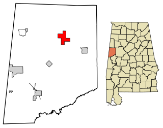
Reform is a city in Pickens County, Alabama, United States. At the 2010 census the population was 1,702, down from 1,978 in 2000. It is located approximately halfway between Columbus, Mississippi and Tuscaloosa on U.S. Route 82.

<span class="mw-page-title-main">Lutcher, Louisiana</span> Town in Louisiana, United States

Lutcher is a town in St. James Parish, Louisiana, United States, on the east bank of the Mississippi River. It is part of the New Orleans Metropolitan Area. The population was 3,559 at the 2010 U.S. census, and 3,127 at the 2020 population estimates program.

<span class="mw-page-title-main">Magnolia, Minnesota</span> Town in Minnesota, United States

Magnolia is a town in Rock County, Minnesota, United States. The population was 222 at the 2010 census. According to the United States Census Bureau, the city has a total area of 0.78 square miles (2.02 km2), all land.

<span class="mw-page-title-main">Renova, Mississippi</span> Town in Mississippi, United States

Renova is a town in Bolivar County, Mississippi, United States.Per the 2020 census, the population was 676. The community was founded by African Americans and remains predominantly African American.

<span class="mw-page-title-main">Winstonville, Mississippi</span> Town in Mississippi, United States

Winstonville is a town in Bolivar County, Mississippi, United States. Per the 2020 census, the population was 153.

<span class="mw-page-title-main">Pachuta, Mississippi</span> Town in Mississippi, United States

Pachuta is a town in Clarke County, Mississippi, United States. The population was 261 at the 2010 census.

<span class="mw-page-title-main">Goodman, Mississippi</span> Town in Mississippi, United States

Goodman is a town in southeastern Holmes County, Mississippi, United States. Per the 2020 census, the population was 1,258.

<span class="mw-page-title-main">West, Mississippi</span> Town in Mississippi, United States

West is a town in northeastern Holmes County, Mississippi, United States. Per the 2020 census, the population was 153. The Mayor of West, MS as of December 2020 is Michael Fancher.

<span class="mw-page-title-main">Louise, Mississippi</span> Town in Mississippi, United States

Louise is a town in Humphreys County, Mississippi. The population was 199 at the 2010 census, down from 315 at the 2000 census.

<span class="mw-page-title-main">Sidon, Mississippi</span> Town in Mississippi, United States

Sidon is a town in Leflore County, Mississippi, United States. The population was 509 at the 2010 census. It is part of the Greenwood, Mississippi micropolitan area.

<span class="mw-page-title-main">Crawford, Mississippi</span> Town in Mississippi, United States

Crawford is a small town in Lowndes County, Mississippi, United States. The population was 641 at the 2010 census.

<span class="mw-page-title-main">Brooksville, Mississippi</span> Town in Mississippi, United States

Brooksville is a town in Noxubee County, Mississippi, United States. The population was 1,223 at the 2010 census.

<span class="mw-page-title-main">Walnut, Mississippi</span> Town in Mississippi, United States

Walnut is a town in Tippah County, Mississippi, United States. The population was 771 at the 2010 census.

<span class="mw-page-title-main">Waynesboro, Mississippi</span> City in Mississippi, United States

Waynesboro is a city in Wayne County, Mississippi, United States. The population was 5,043 at the 2010 census. It is the county seat of Wayne County.

<span class="mw-page-title-main">Sauk Rapids, Minnesota</span> City in Minnesota, United States

Sauk Rapids is a city in Benton County, Minnesota, United States. The population was 13,862 at the 2020 census and is 13,896 according to 2021 census estimates, about a third of Benton County's population. It is on a set of rapids on the Mississippi River near its confluence with the Sauk River.

<span class="mw-page-title-main">Cope, South Carolina</span> Town in South Carolina, United States

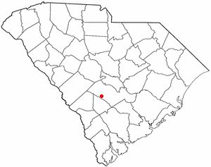
Cope is a town in Orangeburg County, South Carolina, United States. The population was 65 at the 2020 census, a decline from 80 in 2010.

<span class="mw-page-title-main">Oakesdale, Washington</span> Town in Washington, United States

Oakesdale is a town in Whitman County, Washington, United States. The population was 395 at the 2020 census.

<span class="mw-page-title-main">State Line, Mississippi</span> Town in Mississippi, United States

State Line is a town in Greene and Wayne counties, Mississippi, in the United States. The population was 452 at the 2020 census.

<span class="mw-page-title-main">Crenshaw, Mississippi</span> Town in Mississippi, United States

Crenshaw is a town in Panola and Quitman counties in the U.S. state of Mississippi, with a population of 885 in the 2010 census.

References

  1. "2020 U.S. Gazetteer Files". United States Census Bureau. Retrieved July 24, 2022.
  2. "Full text of "Mississippi: Testimony as to denial of elective franchise in Mississippi at the elections of 1875 and 1876, taken under the resolution of the Senate of December 5, 1876"". December 5, 1876. Retrieved December 17, 2017.
  3. "The Artesia Affair". The Weekly Clarion. November 8, 1876. Retrieved December 17, 2017.
  4. "US Gazetteer files: 2010, 2000, and 1990". United States Census Bureau. February 12, 2011. Retrieved April 23, 2011.
  5. "Artesia town, Mississippi". United States Census Bureau. Retrieved April 15, 2023.
  6. "P004 Hispanic or Latino, and Not Hispanic or Latino by Race – 2000: DEC Summary File 1 – Artesia town, Mississippi". United States Census Bureau .
  7. "P2 Hispanic or Latino, and Not Hispanic or Latino by Race – 2010: DEC Redistricting Data (PL 94-171) – Artesia town, Mississippi". United States Census Bureau .
  8. "P2 Hispanic or Latino, and Not Hispanic or Latino by Race – 2020: DEC Redistricting Data (PL 94-171) – Artesia town, Mississippi". United States Census Bureau .
  9. "U.S. Census website". United States Census Bureau . Retrieved January 31, 2008.
  10. "Census of Population and Housing". Census.gov. Retrieved June 4, 2015.
  11. "Jim Roberts Stats". baseball-reference.com. Retrieved April 9, 2023.