Crawford, Mississippi

Last updated

Crawford, Mississippi
Lowndes County Mississippi Incorporated and Unincorporated areas Crawford Highlighted.svg
Location of Crawford, Mississippi
Usa edcp location map.svg
Red pog.svg
Crawford, Mississippi
Location in the United States
Coordinates: 33°18′22″N88°37′19″W / 33.30611°N 88.62194°W / 33.30611; -88.62194
Country Flag of the United States (23px).png  United States
State Flag of Mississippi.svg  Mississippi
County Lowndes
Area
[1]
  Total1.40 sq mi (3.63 km2)
  Land1.40 sq mi (3.63 km2)
  Water0.00 sq mi (0.00 km2)
Elevation
312 ft (95 m)
Population
 (2020)
  Total415
  Density296.43/sq mi (114.44/km2)
Time zone UTC-6 (Central (CST))
  Summer (DST) UTC-5 (CDT)
ZIP code
39743
Area code 662
FIPS code 28-16420
GNIS feature ID0668933

Crawford is a small town in Lowndes County, Mississippi, United States. The population was 641 at the 2010 census.

Contents

History

During the 1840s, a Baptist minister named Peter Crawford lived in the area. When the town was platted in 1852, it was named Crawfordsville. This name was used until 1870, when it was shortened to Crawfordville. Finally in 1879 it was changed to Crawford. [2]

The Mobile and Ohio Railroad came though Crawfordsville in 1857. [3]

Geography

City Hall, Crawford City Hall, Crawford, Mississippi.JPG
City Hall, Crawford

Crawford is located at 33°18′22″N88°37′19″W / 33.30611°N 88.62194°W / 33.30611; -88.62194 (33.306205, -88.621933). [4]

According to the United States Census Bureau, the town has a total area of 1.4 square miles (3.6 km2), all land.

Demographics

Historical population
CensusPop.Note
1880 304
1890 225−26.0%
1900 38972.9%
1910 3961.8%
1920 323−18.4%
1930 3498.0%
1940 3808.9%
1950 374−1.6%
1960 317−15.2%
1970 39123.3%
1980 49526.6%
1990 66834.9%
2000 655−1.9%
2010 641−2.1%
2020 415−35.3%
US Decennial Census [5]

2020 census

Crawford, Mississippi – Racial and ethnic composition
Note: the US Census treats Hispanic/Latino as an ethnic category. This table excludes Latinos from the racial categories and assigns them to a separate category. Hispanics/Latinos may be of any race.
Race / Ethnicity (NH = Non-Hispanic)Pop 2000 [6] Pop 2010 [7] Pop 2020 [8] % 20010% 2010% 2020
White alone (NH)3951285.95%7.96%6.75%
Black or African American alone (NH)60757537792.67%89.70%90.84%
Native American or Alaska Native alone (NH)2400.31%0.62%0.00%
Asian alone (NH)0000.00%0.00%0.00%
Pacific Islander alone (NH)0000.00%0.00%0.00%
Some Other Race alone (NH)0000.00%0.00%0.00%
Mixed Race or Multi-Racial (NH)3780.46%1.09%1.93%
Hispanic or Latino (any race)4420.61%0.62%0.48%
Total655641415100.00%100.00%100.00%

As of the 2010 United States Census, there were 641 people in the town. 89.9% were African American, 8.0% White, 0.6% Native American and 1.6% of two or more races. 0.6% were Hispanic or Latino of any race.

As of the 2000 United States Census [9] there were 655 people, 209 households, and 163 families in the town. The population density was 466.7 inhabitants per square mile (180.2/km2). There were 251 housing units at an average density of 178.9 per square mile (69.1/km2). The racial makeup of the town was 93.13% African American, 5.95% White, 0.31% Native American, 0.15% from other races, and 0.46% from two or more races. Hispanic or Latino of any race were 0.61% of the population.

There were 309 households, out of which 45.0% had children under the age of 18 living with them, 31.6% were married couples living together, 42.1% had a female householder with no husband present, and 22.0% were non-families. 20.6% of all households were made up of individuals, and 7.7% had someone living alone who was 65 years of age or older. The average household size was 3.13 and the average family size was 3.67.

The town population contained 41.5% under the age of 18, 9.0% from 18 to 24, 25.6% from 25 to 44, 17.1% from 45 to 64, and 6.7% who were 65 years of age or older. The median age was 24 years. For every 100 females, there were 75.1 males. For every 100 females age 18 and over, there were 67.2 males.

The median income for a household in the town was $16,786, and the median income for a family was $16,058. Males had a median income of $24,107 versus $14,359 for females. The per capita income for the town was $7,123. About 45.5% of families and 45.7% of the population are below the poverty line, including 60.5% of those under age 18 and 35.3% of those age 65 or over.

Education

The Town of Crawford is served by the Lowndes County School District.

Notable people

Related Research Articles

<span class="mw-page-title-main">Lamar County, Alabama</span> County in Alabama, United States

Lamar County is a county in the U.S. state of Alabama. As of the 2020 census, the population was 13,972. Its county seat is Vernon and it is a dry county. It is named in honor of Lucius Quintus Cincinnatus Lamar, a former Confederate officer and former member of both houses of the United States Congress from Mississippi.

<span class="mw-page-title-main">Hardeman County, Tennessee</span> County in Tennessee, United States

Hardeman County is a county located in the U.S. state of Tennessee. As of the 2020 census, the population was 25,462. Its county seat is Bolivar.

<span class="mw-page-title-main">Lowndes County, Mississippi</span> County in Mississippi, United States

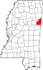
Lowndes County is a county on the eastern border of the U.S. state of Mississippi. As of the 2020 United States Census, the population was 58,879. Its county seat is Columbus. The county is named for U.S. Congressman William Jones Lowndes.

<span class="mw-page-title-main">Fort Deposit, Alabama</span> Town in Alabama, United States

Fort Deposit is a town in Lowndes County, Alabama, United States. Since 1890, it has been the largest town in Lowndes County. At the 2010 census the population was 1,344, up from 1,270 in 2000. It is part of the Montgomery Metropolitan Statistical Area.

<span class="mw-page-title-main">Hayneville, Alabama</span> Town in Alabama, US

Hayneville is a town in Lowndes County, Alabama, United States and its county seat. At the 2010 census the population was 932, down from its record high of 1,177 in 2000. It is also part of the Montgomery Metropolitan Statistical Area. It initially incorporated in 1831, but lapsed, finally reincorporating in 1967. Before 1970, the town appeared only twice on the U.S. Census: in 1850 and 1890. The 1850 estimate of 800 residents ranked it as the largest town in the county at the time.

<span class="mw-page-title-main">Mosses, Alabama</span> Town in Alabama, United States

Mosses is a town in Lowndes County, Alabama, United States. At the 2010 census the population was 1,029, down from 1,101 in 2000. It is part of the Montgomery Metropolitan Statistical Area. It incorporated in 1979.

<span class="mw-page-title-main">Geiger, Alabama</span> Town in Alabama, United States

Geiger is a town in Sumter County, Alabama, United States. It incorporated in 1912. At the 2010 census the population was 170, up from 161 in 2000.

<span class="mw-page-title-main">Madison, Illinois</span> City in Illinois, United States

Madison is a city in Madison and St. Clair counties in the U.S. state of Illinois. The population was 3,171 at the 2020 census, down from 3,891 in 2010. It is home to World Wide Technology Raceway at Gateway and the first Bulgarian Orthodox church in the United States.

<span class="mw-page-title-main">Crawfordsville, Iowa</span> City in Iowa, United States

Crawfordsville is a city in Washington County, Iowa, United States. It is part of the Iowa City, Iowa Metropolitan Statistical Area. The population was 277 at the 2020 census.

<span class="mw-page-title-main">Winstonville, Mississippi</span> Town in Mississippi, United States

Winstonville is a town in Bolivar County, Mississippi, United States. Per the 2020 census, the population was 153.

<span class="mw-page-title-main">Pachuta, Mississippi</span> Town in Mississippi, United States

Pachuta is a town in Clarke County, Mississippi, United States. The population was 261 at the 2010 census.

<span class="mw-page-title-main">West, Mississippi</span> Town in Mississippi, United States

West is a town in northeastern Holmes County, Mississippi, United States. Per the 2020 census, the population was 153. The Mayor of West, MS as of December 2020 is Michael Fancher.

<span class="mw-page-title-main">Louise, Mississippi</span> Town in Mississippi, United States

Louise is a town in Humphreys County, Mississippi. The population was 199 at the 2010 census, down from 315 at the 2000 census.

<span class="mw-page-title-main">Meridian Station, Mississippi</span> Census-designated place in Mississippi, United States

Meridian Station is a census-designated place (CDP) in Lauderdale County, Mississippi, United States, corresponding to the residential portions of Naval Air Station Meridian. The population was 1,090 at the 2010 census.

<span class="mw-page-title-main">Artesia, Mississippi</span> Town in Mississippi, United States

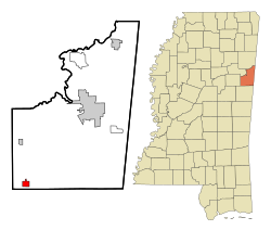
Artesia is a town in Lowndes County, Mississippi. The population was 304 at the 2020 census, down from 440 at the 2010 census.

<span class="mw-page-title-main">Caledonia, Mississippi</span> Town in Mississippi, United States

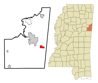
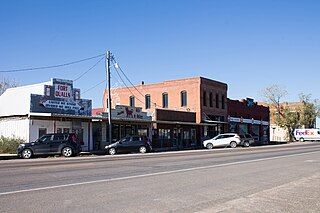
Caledonia is a town in Lowndes County, Mississippi, United States, northeast of Columbus. The population was 1,041 at the 2010 census.

<span class="mw-page-title-main">New Hope, Mississippi</span> Census-designated place in Mississippi, United States

New Hope is a census-designated place (CDP) in Lowndes County, Mississippi, United States. As of the 2010 census, the CDP population was 3,193.

<span class="mw-page-title-main">Walnut, Mississippi</span> Town in Mississippi, United States

Walnut is a town in Tippah County, Mississippi, United States. The population was 771 at the 2010 census.

<span class="mw-page-title-main">Crawford, Texas</span> Town in Texas, United States

Crawford is a town located in western McLennan County, Texas, United States.

<span class="mw-page-title-main">Starkville–Columbus, MS CSA</span> Combined Statistical Area in Mississippi, United States

The Starkville–Columbus, MS Combined Statistical Area was formerly known as Columbus–West Point was defined as consisting of Clay and Lowndes counties in northeastern Mississippi, which were separately treated as the West Point Micropolitan Statistical Area and Columbus Micropolitan Statistical Area, respectively. As of the 2000 census, the CSA had a population of 83,565.

References

  1. "2020 U.S. Gazetteer Files". United States Census Bureau. Retrieved July 24, 2022.
  2. Hairston
  3. Hairston
  4. "US Gazetteer files: 2010, 2000, and 1990". US Census Bureau. February 12, 2011. Retrieved April 23, 2011.
  5. "Census of Population and Housing". Census.gov. Retrieved June 4, 2015.
  6. "P004 Hispanic or Latino, and Not Hispanic or Latino by Race – 2000: DEC Summary File 1 – Crawford town, Mississippi". United States Census Bureau .
  7. "P2 Hispanic or Latino, and Not Hispanic or Latino by Race – 2010: DEC Redistricting Data (PL 94-171) – Crawford town, Mississippi". United States Census Bureau .
  8. "P2 Hispanic or Latino, and Not Hispanic or Latino by Race – 2020: DEC Redistricting Data (PL 94-171) – Crawford town, Mississippi". United States Census Bureau .
  9. "US Census website". US Census Bureau. Retrieved January 31, 2008.
  10. "Attorney General: Thomas Watt Gregory". justice.gov. Retrieved April 9, 2023.

See also