Until 1974, Montgomeryshire was an administrative county in mid Wales, later classed as one of the thirteen historic counties of Wales. It was named after its county town, Montgomery, which in turn was named after one of William the Conqueror's main counsellors, Roger de Montgomerie, who was the 1st Earl of Shrewsbury.

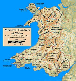
The Kingdom of Powys was a Welsh successor state, petty kingdom and principality that emerged during the Middle Ages following the end of Roman rule in Britain. It very roughly covered the northern two-thirds of the modern county of Powys and part of today's English West Midlands. More precisely, and based on the Romano-British tribal lands of the Ordovices in the west and the Cornovii in the east, its boundaries originally extended from the Cambrian Mountains in the west to include the modern West Midlands region of England in the east. The fertile river valleys of the Severn and Tern are found there, and this region is referred to in later Welsh literature as "the Paradise of Powys".
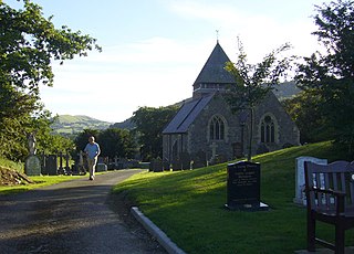
Llandinam is a village and community in Montgomeryshire, Powys, central Wales, between Newtown and Llanidloes, located on the A470. As a community, Llandinam is made up of the village itself, small hamlets including Plas Dinam and Little London and several farms. The village itself has a population of around 576 with 56% born in Wales.

Powys Fadog was the northern portion of the former princely realm of Powys. The princes of Powys Fadog would build their royal seat at Castell Dinas Brân, and their religious center at Valle Crucis Abbey. Some of its lordships included those of Maelor, Mochnant, Glyndyfrdwy, Yale, and Bromfield and Yale. Following the division of Powys, their cousin branch, the princes of Powys Wenwynwyn, would build Powis Castle.
Gruffydd ap Gwenwynwyn was a Welsh king who was lord of the part of Powys known as Powys Wenwynwyn and sided with Edward I in his conquest of Wales of 1277 to 1283.
Perfeddwlad or Y Berfeddwlad was an historic name for the territories in Wales lying between the River Conwy and the River Dee. comprising the cantrefi of Rhos, Rhufoniog, Dyffryn Clwyd and Tegeingl. Perfeddwlad thus was also known as the Four Cantrefs.
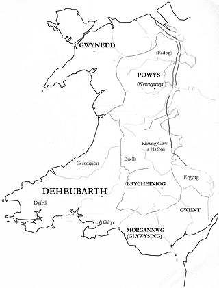
Gwent was a medieval Welsh kingdom, lying between the Rivers Wye and Usk. It existed from the end of Roman rule in Britain in about the 5th century until the Norman invasion of Wales in the 11th century. Along with its neighbour Glywyssing, it seems to have had a great deal of cultural continuity with the earlier Silures, keeping their own courts and diocese separate from the rest of Wales until their conquest by Gruffydd ap Llywelyn. Although it recovered its independence after his death in 1063, Gwent was the first of the Welsh kingdoms to be overrun following the Norman conquest.

Gwrtheyrnion or Gwerthrynion was a commote in medieval Wales, located in Mid Wales on the north side of the River Wye; its historical centre was Rhayader. It is said to have taken its name from the legendary king Vortigern. For most of the medieval era, it was associated with the cantref of Buellt and then Elfael, small regional kingdoms whose rulers operated independently of other powers. In the Norman era, like the rest of the region between Wye and Severn it came to be dominated by Marcher Lordships.
Rhwng Gwy a Hafren was a region of medieval Wales, located in the Welsh Marches between Powys to the north and Brycheiniog to the south. It was bounded by the rivers Wye and Severn. It covered about the same territory as Radnorshire, now part of the county of Powys. The region first came into its own in the 9th or 10th centuries, when it was ruled by leaders who operated independently of the surrounding kingdoms. After the Norman invasion, it comprised the central part of the Welsh Marches and was the site of frequent struggles between Welsh and Norman forces.

Wales in the High Middle Ages covers the 11th to 13th centuries in Welsh history. Beginning shortly before the Norman invasion of the 1060s and ending with the Conquest of Wales by Edward I between 1278 and 1283, it was a period of significant political, cultural and social change for the country.

Ial or Yale was a commote of medieval Wales within the cantref of Maelor in the Kingdom of Powys. When the Kingdom was divided in 1160, Maelor became part of the Princely realm of Powys Fadog, and belonged to the Royal House of Mathrafal. Yale eventually merged with another commote and became the Lordship of Bromfield and Yale, later a royal lordship under the Tudors and Stuarts.

The history of Gwynedd in the High Middle Ages is a period in the History of Wales spanning the 11th through the 13th centuries. Gwynedd, located in the north of Wales, eventually became the most dominant of Welsh polities during this period. Contact with continental courts allowed for Gwynedd to transition from a petty kingdom into an increasingly sophisticated principality of seasoned courtiers capable of high level deplomacy and representation; not only with the Angevine kings, but also the king of France and the Papal See. Distinctive achievements in Gwynedd include further development of Medieval Welsh literature, particularly poets known as the Beirdd y Tywysogion associated with the court of Gwynedd; the reformation of bardic schools; and the continued development of Cyfraith Hywel. All three of these further contributed to the development of a Welsh national identity in the face of Anglo-Norman encroachment of Wales.

The Royal House of Mathrafal began as a cadet branch of the Welsh Royal House of Dinefwr, taking their name from Mathrafal Castle. They effectively replaced the House of Gwertherion, who had been ruling the Kingdom of Powys since late Roman Britain, through the politically advantageous marriage of an ancestor, Merfyn the Oppressor. King Bleddyn ap Cynfyn would join the resistance of the Anglo-Saxon King Harold Godwinson, against the invasion of William the Conqueror, following the Norman Conquest of England. Thereafter, they would struggle with the Plantagenets and the remaining Welsh Royal houses for the control of Wales. Although their fortunes rose and fell over the generations, they are primarily remembered as Kings of Powys and last native Prince of Wales.

The conquest of Wales by Edward I took place between 1277 and 1283. It is sometimes referred to as the Edwardian conquest of Wales, to distinguish it from the earlier Norman conquest of Wales. In two campaigns, in 1277 and 1282–83, respectively, Edward I of England first greatly reduced the territory of Llywelyn ap Gruffudd, and then completely overran it, as well as the other remaining Welsh principalities.
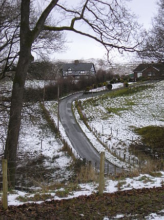
Plasau Duon or Plasauduon is a timber-framed house, formerly in the parish of Carno, but now within the area of the community council of Caersws in the historic county of Montgomeryshire, and now in Powys, Wales. It is located on a site above the left bank of the Afon Carno, on a farm road leading off the lane from the A.470 to Bwlch-y-garreg. It is a fine example of a ‘’Severn Valley’’ house and has a Grade II* listing. It is likely to have been built in the second half of the 16th. century.

Mochnant was a medieval cantref in the Kingdom of Powys. In the 12th century it was divided into the commotes of Mochnant Is Rhaeadr and Mochnant Uwch Rhaeadr.

Cedewain was a medieval cantref in the Kingdom of Powys. It possibly consisted of the commotes (cymydau) of Cynan, Hafren and Uwch Hanes. Other sources give the commotes as Cedewain, Eginlle and Ceri.
Y Gorddwr was a medieval commote in the cantref of Ystlyg in the Kingdom of Powys. It was on the eastern side of the River Severn bordering England, on the west it was bordered by two of the other commotes of Ystlyg - Deuddwr in the north and Ystrad Marchell in the south. Its Welsh name could mean "the upper water"; gor- "upper-", dŵr "water".
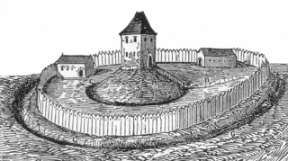
Tomen yr Allt was a Medieval motte and bailey defensive castle near Llanfyllin in Powys, Wales. "Tomen ar hallt" is modern Welsh for "mound on the wooded hillside."