Rhwng Gwy a Hafren

Last updated
Rhwng.Gwy.a.Hafren.jpg

Rhwng Gwy a Hafren (English: Between Wye and Severn) was a region of medieval Wales, located in the Welsh Marches between Powys to the north and Brycheiniog to the south. It was bounded by the rivers Wye (Welsh : Gwy) and Severn (Welsh : Hafren). It covered about the same territory as Radnorshire, now part of the county of Powys. The region first came into its own in the 9th or 10th centuries, when it was ruled by leaders who operated independently of the surrounding kingdoms. After the Norman invasion, it comprised the central part of the Welsh Marches and was the site of frequent struggles between Welsh and Norman forces.

Contents

Name and area

Map showing the possible cantrefs and commotes of Rhwng Gwy a Hafren discussed (Cwmwd Deuddwr is shown as Elenydd) Map of the Cantrefs and Commotes of Rhwng Gwy a Hafren.svg
Map showing the possible cantrefs and commotes of Rhwng Gwy a Hafren discussed (Cwmwd Deuddwr is shown as Elenydd)

The name Rhwng Gwy a Hafren appears in various medieval lists of cantrefs and commotes, and is rendered in Latin in the works of Gerald of Wales. [1] The name means "between the Wye and the Severn", and those two rivers were its most important boundaries. However, the territories associated with it are not always consistent: generally, the lists include the cantrefs of Elfael and Maelienydd and the commote of Gwrtheyrnion. [2] The cantref of Buellt is also often associated with the region, despite being located across the Wye, [1] and there is some conjecture that may tie in Arwystli as well. [3] The small commotes of Ceri in Maelienydd and Cwmwd Deuddwr north of Buellt (and also across the Wye) were located in this area and appear in some sources, but are not included in the lists of divisions. [4]

History

In the Iron Age and the Roman era, Rhwng Gwy a Hafren made up part of the territory of the Ordovices. [4] During the Early Middle Ages the region was evidently associated with the Kingdom of Powys, although in later centuries the monarchs of Powys exercised no control over it. [1] After the 9th or 10th centuries, the region was ruled by families tracing their descent from the shadowy figures of Iorwerth Hirflawdd and his descendant Elystan Glodrydd. [5] Although these families had lineal ties to Powys, they operated independently of the Powys monarchy. [5] In the early 9th century another dynasty arose which formed Buellt and Gwerthrynion into an independent minor kingdom. [5] The rulers of this kingdom did not trace their descent from the royal line of Powys, but from Pascent or Pasgen, a reputed son of the early king Vortigern. [5] However the Powys connection was never totally forgotten. Welsh topographical lore remembered the traditional borders of Powys as extending to the Wye, while in 1176, Bishop Adam Parvipontanus tried to claim Ceri as part of his Diocese of St Asaph, apparently based on the old territorial claims of Powys over Rhwng Gwy a Hafren. [1]

In 1093 much of the territory was divided up between the Marcher Lords, including Roger de Montgomerie, Ranulph de Mortimer, and Philip de Braose. Norman authority suffered a serious reverse within fifty years with the emergence of Cadwallon ap Madog and his younger brother Einion Clud as Princes of Elfael and Maelienydd. In 1165 Cadwallon and Einion Clud combined forces and marched with the rest of independent Wales to join the massed Welsh army under the leadership of Owain Gwynedd at Corwen, which humbled the army of Henry II of England. In 1175 these two brothers travelled to Gloucester with many of their compatriots from south Wales, as allies of the Lord Rhys ap Gruffudd of Deheubarth.

Throughout the 13th century the territory as described was gradually reoccupied by the English Marcher Lords, and Roger Mortimer built a castle at Cefnllys to consolidate his gains in Maelienydd. Descendants of Cadwallon and Einion Clud are recorded as holding client fortresses in the area until the 1240s, when they changed allegiance to support Llywelyn the Great and later his grandson Llywelyn ap Gruffudd. The territory was annexed by the latter in 1267 under the Treaty of Montgomery. However, following the defeat of the last native Prince of Wales at the hands of Edward I of England in 1282, most remaining native landowners in the area were dispossessed. The county of Radnorshire was formed out of the area under the various Tudor Laws in Wales Acts in the 16th century. Welsh language speakers formed the majority of the population until the end of the 19th century.

Cynllibiwg

Some part of Rhwng Gwy a Hafren may have been known as Cynllibiwg (or some variation) during the Early Middle Ages. The Red Book of the Exchequer, a mainly 13th-century English compilation of landholdings, mentions a region of seven cantrefs "between Severn and Wye" that had been known as Kenthlebiac during the time of Rhys ab Owain of Deheubarth. [3] This name is evidently attested in the 9th-century Historia Brittonum , which describes a marvellous spring in the regione of Cinlipiuc brimming with fish despite not being fed by a stream. [6] The Domesday Book of 1086 refers to a place called Calcebuef, which rendered ten shillings; one editor suggests this is a corruption of Cynllibiwg and that it derives ultimately from the name of Saint Cynllo. [7]

The extent of Cynllibiwg is unknown. Hubert Hall suggests that the number of cantrefs given in the Red Book of the Exchequer be amended from seven to three, perhaps Arwystli, Maelienydd, and Elfael. [3] The Red Book mentions that these cantrefs were part of Powys in the time of "Meic Menbis", but were no longer such in the 13th century. [3] Cynllibiwg has been postulated as an early kingdom, [8] but is not mentioned by the great majority of historians. [9]

Notes

  1. 1 2 3 4 Lloyd, p. 252.
  2. Owen, p. 203; Lloyd, p. 253.
  3. 1 2 3 4 Hall, vol. II p. 762.
  4. 1 2 Lloyd, p. 253.
  5. 1 2 3 4 Owen, p. 203.
  6. Historia Brittonum, ch. 70; Morris, p. 81.
  7. Thorn and Thorn, A10 (f.179b) and notes on it.
  8. Remfry, "Discovering the lost kingdom of Radnor".
  9. Standard works on Welsh history and early/medieval Wales which do not mention Cynllibiwg at all include the following: John Davies, History of Wales (Penguin, 1992); Sir J. E. Lloyd, A history of Wales from the earliest times to the Edwardian Conquest (revised ed., 1937), the classic survey of the period; R. R. Davies, Conquest, Coexistence and Change: Wales 1063-1415 (Oxford University Press, 1991), probably the most comprehensive and authoritative single volume survey of the period; Wendy Davies, Wales in the Early Middle Ages (University of Leicester Press, 1982), (refers once to Cynllibiwg as a named early region, based on Nennius); J. Beverley Smith, Llywelyn ap Gruffudd, Tywysog Cymru (University of Wales Press, 1986), the most detailed history of the reign of Llywelyn ap Gruffudd, a period which saw him leading several campaigns in the area claimed as a kingdom of Cynllibiwg.

Related Research Articles

<span class="mw-page-title-main">Kingdom of Gwynedd</span> Kingdom in northwest Wales, 401–1216

The Kingdom of Gwynedd was a Welsh kingdom and a Roman Empire successor state that emerged in sub-Roman Britain in the 5th century during the Anglo-Saxon settlement of Britain.

<span class="mw-page-title-main">Cefnllys Castle</span> Medieval castle in Powys, Wales

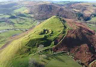
Cefnllys Castle was a medieval spur castle in Radnorshire, Wales. Two successive masonry castles were built on a ridge above the River Ithon known as Castle Bank in the thirteenth century, replacing a wooden motte-and-bailey castle constructed by the Normans nearby. Controlling several communication routes into the highlands of Mid Wales, the castles were strategically important within the Welsh Marches during the High Middle Ages. As the seat of the fiercely contested lordship and cantref of Maelienydd, Cefnllys became a source of friction between Llywelyn ap Gruffudd and Roger Mortimer in the prelude to Edward I's conquest of Wales (1277–1283). Cefnllys was also the site of a borough and medieval town.

<span class="mw-page-title-main">Maelienydd</span> Welsh medieval cantref and lordship

Maelienydd, sometimes spelt Maeliennydd, was a cantref and lordship in east central Wales covering the area from the River Teme to Radnor Forest and the area around Llandrindod Wells. The area, which is mainly upland, is now in Powys. During the Middle Ages it was part of the region known as Rhwng Gwy a Hafren and its administrative centre was at Cefnllys Castle.

Kerry is a village and geographically large community in Montgomeryshire, Powys, Wales.

<span class="mw-page-title-main">Kingdom of Gwent</span> Kingdom in South Wales

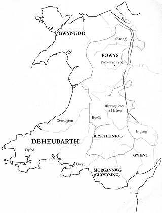
Gwent was a medieval Welsh kingdom, lying between the Rivers Wye and Usk. It existed from the end of Roman rule in Britain in about the 5th century until the Norman invasion of Wales in the 11th century. Along with its neighbour Glywyssing, it seems to have had a great deal of cultural continuity with the earlier Silures, keeping their own courts and diocese separate from the rest of Wales until their conquest by Gruffydd ap Llywelyn. Although it recovered its independence after his death in 1063, Gwent was the first of the Welsh kingdoms to be overrun following the Norman conquest.

<span class="mw-page-title-main">Cwmhir Abbey</span>

Cwmhir Abbey, near Llandrindod Wells in Powys, is a Welsh Cistercian monastery founded in 1176 by Cadwallon ap Madog. A spurious tale was later recorded that the abbey was founded in 1143 by Meredudd ap Maelgwn at Ty-faenor, and then refounded at the present location near the village of Abbeycwmhir in 1176. There does appear to be a site movement from Ty-faenor, but Maredudd ap Maelgwn was prince of Maelienydd in 1215 under Prince Llywelyn ab Iorwerth of Gwynedd, who then controlled the district. The later charter to the abbey in 1215 caused the confusion and led to the belief that Maredudd had founded the abbey in 1143.

Cynllibiwg was evidently a place name in early medieval Wales.

<span class="mw-page-title-main">Gwrtheyrnion</span> Welsh medieval commote

Gwrtheyrnion or Gwerthrynion was a commote in medieval Wales, located in Mid Wales on the north side of the River Wye; its historical centre was Rhayader. It is said to have taken its name from the legendary king Vortigern. For most of the medieval era, it was associated with the cantref of Buellt and then Elfael, small regional kingdoms whose rulers operated independently of other powers. In the Norman era, like the rest of the region between Wye and Severn it came to be dominated by Marcher Lordships.

Cadwallon ap Madog was the son of Madog ab Idnerth who had died in 1140, while Idnerth was a grandson of Elystan Glodrydd who had died in around 1010 and had founded a dynasty in the Middle Marches of Wales, in the area known as Rhwng Gwy a Hafren.

<span class="mw-page-title-main">Ial</span> Welsh medieval commote

Ial or Yale was a commote of medieval Wales within the cantref of Maelor in the Kingdom of Powys. When the Kingdom was divided in 1160, Maelor became part of the Princely realm of Powys Fadog, and belonged to the Royal House of Mathrafal.

<span class="mw-page-title-main">Elfael</span> Welsh medieval cantref

Elfael was one of a number of Welsh cantrefi occupying the region between the River Wye and river Severn, known as Rhwng Gwy a Hafren, in the early Middle Ages. It was divided into two commotes, Is Mynydd and Uwch Mynydd, separated by the chain of hills above Aberedw. In the late medieval period, it was a marcher lordship. However, after the Laws in Wales Act of 1535, it was one of the territorial units which went to make up the county of Radnorshire in 1536.

<span class="mw-page-title-main">Elystan Glodrydd</span> Welsh royal

Elystan Glodrydd, also known as "Æthelstan the Famous" and "The Renowned," was, according to Welsh genealogical tracts, the founder of the fifth Royal Tribe of Wales. He was the Prince of Buellt, and later also of Fferreg ; in the century after his death, Fferreg split into Maelienydd and Elfael

<span class="mw-page-title-main">History of Gwynedd during the High Middle Ages</span>

The history of Gwynedd in the High Middle Ages is a period in the History of Wales spanning the 11th through the 13th centuries. Gwynedd, located in the north of Wales, eventually became the most dominant of Welsh polities during this period. Contact with continental courts allowed for Gwynedd to transition from a petty kingdom into an increasingly sophisticated principality of seasoned courtiers capable of high level deplomacy and representation; not only with the Angevine kings, but also the king of France and the Papal See. Distinctive achievements in Gwynedd include further development of Medieval Welsh literature, particularly poets known as the Beirdd y Tywysogion associated with the court of Gwynedd; the reformation of bardic schools; and the continued development of Cyfraith Hywel. All three of these further contributed to the development of a Welsh national identity in the face of Anglo-Norman encroachment of Wales.

<span class="mw-page-title-main">Cwmdauddwr</span> Village in Powys, Wales

Cwmdauddwr is a village in Powys, Wales. It is contiguous with the town of Rhayader on the opposite side of the River Wye. The village is located on the B4518 road linking Rhayader with the Elan Valley Reservoirs.

<span class="mw-page-title-main">Arwystli</span> Welsh medieval cantref

Arwystli was a cantref in mid Wales in the Middle Ages, located in the headland of the River Severn. It was chiefly associated with the Kingdom of Powys, but was heavily disputed between Powys, Gwynedd, and the Norman Marcher Lords for hundreds of years, and was the scene of many skirmishes between those groups. Like many other cantrefs and subdivisions, it was divided up by the Laws in Wales Acts in the 16th century.

<span class="mw-page-title-main">Buellt</span> Welsh medieval cantref

Buellt or Builth was a cantref in medieval Wales, located west of the River Wye. Unlike most cantrefs, it was not part of any of the major Welsh kingdoms for most of its history, but was instead ruled by an autonomous local dynasty. During the Norman era it was associated with Rhwng Gwy a Hafren, a region independent of the Welsh monarchies and controlled by Norman Marcher Lords. In the 16th century, it was reorganized as a hundred and joined with the former kingdom of Brycheiniog to form the county of Brecknockshire.

<span class="mw-page-title-main">Cedewain</span> Welsh medieval cantref

Cedewain was a medieval cantref in the Kingdom of Powys. It possibly consisted of the commotes (cymydau) of Cynan, Hafren and Uwch Hanes. Other sources give the commotes as Cedewain, Eginlle and Ceri.

<span class="mw-page-title-main">Rhayader Castle</span> Ruined castle in Powts, Wales

Rhayader Castle is the remains of a motte-and-bailey castle in the town of Rhayader, Powys, Wales. The available documentary sources are not clear enough to distinguish between this site and the castle mound across the river and one or the other was probably built by Rhys ap Gruffydd, Prince of Deheubarth, in 1177. At that time the river formed the border between Gwrtheyrnion and the independent state of Buellt; the town of Rhayader is on the Gwrtheyrnion side of the river.

<span class="mw-page-title-main">Dinieithon</span> Welsh medieval commote

Dinieithon was a commote within the cantref of Maelienydd, in the medieval region of Rhwng Gwy a Hafren in Wales. It was situated near the modern town of Llandrindod Wells.

Cantref Coch was a cantref associated with the kingdoms of Ergyng, Gwent and the later Kingdom of Glamorgan. Its area is defined as the land between the River Severn and the River Wye, with the Severn Sea as its southern border although its northern border is less certain. Cantref Coch is one of the few medieval cantrefi named by Welsh writers that is not within the modern nation of Wales.

References

52°20′N3°19′W / 52.33°N 3.32°W / 52.33; -3.32