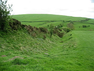
Offa's Dyke is a large linear earthwork that roughly follows the border between England and Wales. The structure is named after Offa, the Anglo-Saxon king of Mercia from AD 757 until 796, who is traditionally believed to have ordered its construction. Although its precise original purpose is debated, it delineated the border between Anglian Mercia and the Welsh kingdom of Powys.

The history of what is now Wales begins with evidence of a Neanderthal presence from at least 230,000 years ago, while Homo sapiens arrived by about 31,000 BC. However, continuous habitation by modern humans dates from the period after the end of the last ice age around 9000 BC, and Wales has many remains from the Mesolithic, Neolithic, and Bronze Age. During the Iron Age, as in all of Britain south of the Firth of Forth, the culture had become Celtic, with a common Brittonic language. The Romans, who began their conquest of Britain in AD 43, first campaigned in what is now northeast Wales in 48 against the Deceangli, and gained total control of the region with their defeat of the Ordovices in 79. The Romans departed from Britain in the 5th century, opening the door for the Anglo-Saxon settlement. Thereafter, the culture began to splinter into a number of kingdoms. The Welsh people formed with English encroachment that effectively separated them from the other surviving Brittonic-speaking peoples in the early middle ages.

Kilpeck is a village and civil parish in the county of Herefordshire, England. It is about nine miles (14 km) southwest of Hereford, just south of the A465 road and Welsh Marches Line to Abergavenny, and about five miles (8 km) from the border with Wales. On 1 April 2019, the parishes of Kenderchurch, St Devereux, Treville and Wormbridge were merged with Kilpeck.
The Welsh Marches is an imprecisely defined area along the border between England and Wales in the United Kingdom. The precise meaning of the term has varied at different periods.
Leominster is a market town in Herefordshire, England; it is located at the confluence of the River Lugg and its tributary the River Kenwater. The town is 12 miles north of Hereford and 7 miles south of Ludlow in Shropshire. With a population of 11,700, Leominster is the largest of the five towns in the county; the others being Ross-on-Wye, Ledbury, Bromyard and Kington.

Weston under Penyard is a small village in Herefordshire, England. The population of the civil parish at the 2011 Census was 1,007.

Whitchurch is a village in Herefordshire situated on the A40, connecting nearby Ross-on-Wye to Welsh town Monmouth. It is located within the Wye Valley Area of Outstanding Natural Beauty.
The known history of Herefordshire starts with a shire in the time of King Athelstan, and Herefordshire is mentioned in the Anglo-Saxon Chronicle in 1051. The first Anglo-Saxon settlers, the 7th-century Magonsætan, were a sub-tribal unit of the Hwicce who occupied the Severn valley. The undulating hills of marl clay were surrounded by the Welsh mountains to the west; by the Malvern Hills to the east; by the Clent Hills of the Shropshire borders to the north, and by the indeterminate extent of the Forest of Dean to the south. The shire name first recorded in the Anglo-Saxon Chronicle may derive from "Here-ford", Old English for "army crossing", the location for the city of Hereford.

Archenfield is the historic English name for an area of southern and western Herefordshire in England. Since the Anglo-Saxons took over the region in the 8th century, it has stretched between the River Monnow and River Wye, but it derives from the once much larger Welsh kingdom of Ergyng.

Dubricius or Dubric was a 6th-century British ecclesiastic venerated as a saint. He was the evangelist of Ergyng and much of south-east Wales.
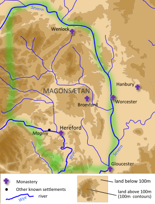
Magonsæte was a minor sub-kingdom of the greater Anglo-Saxon kingdom of Mercia, thought to be coterminous with the Diocese of Hereford.
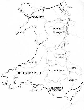
Gwent was a medieval Welsh kingdom, lying between the Rivers Wye and Usk. It existed from the end of Roman rule in Britain in about the 5th century until the Norman invasion of Wales in the 11th century. Along with its neighbour Glywyssing, it seems to have had a great deal of cultural continuity with the earlier Silures, keeping their own courts and diocese separate from the rest of Wales until their conquest by Gruffydd ap Llywelyn. Although it recovered its independence after his death in 1063, Gwent was the first of the Welsh kingdoms to be overrun following the Norman conquest.
Peibo Clafrog, was King of Ergyng in south-east Wales in the 5th or 6th century. He is chiefly known from the legends of Saint Dubricius, who was supposedly his grandson. The contemporary rendering of this name would seem to be Peibio, as in Garthbeibio, a parish in Montgomeryshire, or Ynys Beibio, near Holyhead.
Ewyas was a possible early Welsh kingdom which may have been formed around the time of the Roman withdrawal from Britain in the 5th century. The name was later used for a much smaller commote or administrative sub-division, which covered the area of the modern Vale of Ewyas and a larger area to the east including the villages of Ewyas Harold and Ewyas Lacy.

Ariconium was a road station of Roman Britain mentioned in Iter XIII of the Iter Britanniarum of the Antonine Itineraries. It was located at Bury Hill in the parish of Weston under Penyard, about 3 miles (5 km) east of Ross on Wye, Herefordshire, and about 15 miles (24 km) southeast of Hereford. The site existed prior to the Roman era, and then came under Roman control. It was abandoned, perhaps shortly after 360, but precisely when and under what circumstances is unknown.
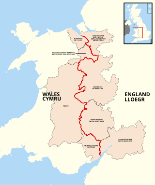
The England–Wales border, sometimes referred to as the Wales–England border or the Anglo-Welsh border, runs for 160 miles (260 km) from the Dee estuary, in the north, to the Severn estuary in the south, separating England and Wales.

St Weonards is a village and civil parish in Herefordshire, England, located 10 miles (16 km) south of Hereford, 7 miles (11 km) west of Ross-on-Wye and 8 miles (13 km) north of Monmouth, on the A466 road. Within the parish and also on the A466 is the hamlet of Sandyway. St Weonards lies within the area known to the Saxons as Archenfield, previously the kingdom of Ergyng, adjoining the modern border with Wales. Ergyng was later reduced to a semi-autonomous cantref retaining Welsh language and customs until the early nineteenth century.

Cyfeilliog or Cyfeiliog was a bishop in south-east Wales. The location and extent of his diocese is uncertain, but lands granted to him are mainly close to Caerwent, suggesting that his diocese covered Gwent. There is evidence that his diocese extended into Ergyng. He is recorded in charters dating from the mid-880s to the early tenth century.

Cantref Coch was an area associated with the ancient kingdoms of Ergyng, Gwent and the later Kingdom of Glamorgan. Cantref Coch is linked with the modern Forest of Dean and is defined as the land between the River Severn and the River Wye, with the Severn Sea as its southern border although its northern border is less certain. It is one of the few medieval cantrefi named by Welsh writers that is not within the modern nation of Wales.
