Newton Upper Falls is a village situated on the east bank of the Charles River in the city of Newton, Massachusetts, in the United States.
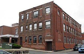
The Berger Factory is a historic factory building at 37 Williams Street in Boston, Massachusetts. Built in 1902, it was home to one of the nation's first manufacturers of precision engineering and surveying instruments, and a surviving example of Roxbury's late 19th-century industrial development. It was listed on the National Register of Historic Places in 1980, and now houses residences.

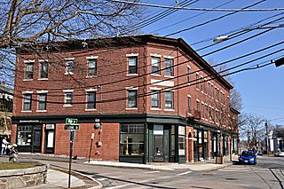
The Beach-Knapp District encompasses a collection of six 19th-century buildings in the Chinatown neighborhood of Boston, Massachusetts. It is centered at the corner of Beach and Knapp Streets, and includes three buildings on the south side of Beach Street, and three on the east side of Knapp. The buildings encapsulate the transition of the area from a predominantly residential area to a mixed residential-light industrial area in the 19th century. At 5 and 7 Knapp Street stand two Greek Revival residential structures, both built in the 1830s. The four story Renaissaince Revival building at 7-15 Beach Street was built c. 1885, and was historically used as a hotel. The other three buildings, 17-23 Beach, 25-29 Beach, and 9-23 Knapp, are all commercial buildings dating between 1885 and 1906; two of them were designed by Shepley, Rutan and Coolidge.

The Dorchester-Milton Lower Mills Industrial District is a historic district on both sides of the Neponset River in the Dorchester area of Boston and in the town of Milton, Massachusetts. It encompasses an industrial factory complex, most of which was historically associated with the Walter Baker & Company, the first major maker of chocolate products in the United States. The industrial buildings of the district were built between about 1868 and 1947, and were listed on the National Register of Historic Places in 1980, with a slight enlargement in 2001.

The Frederick Douglass Square Historic District is a historic district roughly bounded by Hammond Street, Cabot Street, Windsor Street, and Westminster Street, in the Lower Roxbury area of Boston, Massachusetts. It covers a 5-acre (2.0 ha) that is a remarkably well-preserved and cohesive residential development created as the result of one of Boston's many land-reclamation projects in the 19th century. This area, originally salt marshes that flooded at high tide, was at first gradually filled in as the Boston Neck was widened with the construction of Tremont Street and railroad lines. The Tremont Improvement Company acquired a remnant portion of the salt marshes by the early 1860s, and built a series of single-family row houses on the land that resulted from filling it in. The district includes most of the residential properties on Warwick, Greenwich, and Sussex Streets, as well as clusters of properties on adjacent streets.

The Lower Roxbury Historic District is a historic district encompassing an isolated pocket of 1890s mixed residential-commercial property in the lower Roxbury neighborhood of Boston, Massachusetts. Bounded by Tremont, Columbus, and Burke Streets and St. Cyprian's Place, the area contains a well-kept collection of architect designed buildings that survived late 20th-century urban redevelopment. The district was added to the National Register of Historic Places in 1994.

Mount Pleasant Historic District is a historic district encompassing a cluster of well-preserved 19th-century residential buildings on Forest Street and Mount Pleasant Avenue in the Roxbury neighborhood of Boston, Massachusetts. First developed in 1833, it was one Roxbury's first speculative residential subdivision developments. The district features Greek Revival, Italianate, and Romanesque architecture, and was added to the National Register of Historic Places in 1989.

The Sumner Hill Historic District encompasses a predominantly residential area of high-quality late 19th-century residences in the Jamaica Plain neighborhood of Boston, Massachusetts. It is roughly bounded by Seaverns Avenue, Everett Street, Carolina Avenue, and Newbern Street just east of the neighborhoods commercial Centre Street area. The district features Second Empire, Italianate, and Queen Anne style architecture, and was listed on the National Register of Historic Places in 1987.

The East Cambridge Historic District encompasses the historic center of East Cambridge, Massachusetts. It includes the major buildings that were built to house county services for Middlesex County beginning in the 1810s, and a cluster of largely vernacular Greek Revival worker housing located west of the county complex on Otis, Thorndike, Spring, and Sciarappa Streets. The district was listed on the National Register of Historic Places in 1983.

The Lower Highlands Historic District encompasses one of the oldest residential areas of Fall River, Massachusetts. The district is roughly bounded by Cherry, Main, Winter, and Bank Streets, and is located just east of the Downtown Fall River Historic District and directly south of the Highlands Historic District. This area was settled by 1810, has architecture tracing the city's growth as a major industrial center. The historic district was added to the National Register of Historic Places in 1984.

The Millis Center Historic District is an historic district on Curve, Daniels, Exchange, Irving, Lavender, Main, and Union Streets in Millis, Massachusetts. It encompasses the historic mid-to-late-19th century village center of the town, including the residential area north of Main Street, two 19th-century industrial complexes, and civic and institutional buildings. It was added to the National Register of Historic Places in 2007.

The Kendal Green Historic District is a rural residential district running along North Avenue in Weston, Massachusetts. It extends for about three-quarters of a mile, and includes elements representative of the development of Weston from a rural agricultural community to a residential suburb of Boston. In addition to a variety of predominantly residential and agricultural properties, it includes two formerly industrial sites important in Weston's history: the site of the Hobbs Tannery, and that of the Hook and Hastings Organ Factory. The district was listed on the National Register of Historic Places in 2000.
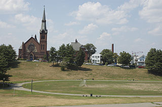
The South Common Historic District of Lowell, Massachusetts, encompasses the city's South Common and the various public, religious, and private residential buildings that flank its borders. The South Common, about 22.5 acres (9.1 ha) in size, was purchased by the city in 1845 in an auction by the Proprietors of Locks and Canals, who owned much of the city's industrial area. Although the common was landscaped, it was not apparently done so to a plan. It quickly became lined with fashionable residences, and several iconic public buildings, including the 1850 courthouse, a Romantic Revival structure designed by Ammi Young, and a series of Gothic Revival churches. Highland Avenue was built out with a series of fine Italianate houses.
The Washington Street Historic District encompasses a residential area of Middletown, Connecticut that has a long history as a fashionable and desirable neighborhood. Extending along Washington Street and Washington Terrace between Main and Jackson Streets, the area has a broad diversity of residential architecture dating from 1752 to 1931, reflecting the city's patterns of growth. The district was listed on the National Register of Historic Places in 1985.

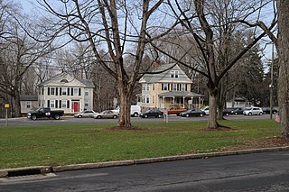
The Longwood Historic District is roughly bounded by Chapel, St. Marys, Monmouth, and Kent Sts. in Brookline, Massachusetts. The area was developed in the mid-19th century by David Sears and Amos Adams Lawrence as a fashionable residential area, and retains a number of architecturally distinguished buildings, including the Longwood Towers complex at 20 Chapel Street, Christ's Church Longwood, and Church of Our Saviour, Brookline. The district was listed on the National Register of Historic Places on September 13, 1978.

Mount Vernon Triangle is a neighborhood and community improvement district in the northwest quadrant of Washington, D.C. Originally a working-class neighborhood established in the 19th century, present-day Mount Vernon Triangle experienced a decline in the mid-20th century as it transitioned from residential to commercial and industrial use. The neighborhood has undergone significant and rapid redevelopment in the 21st century. It now consists mostly of high-rise condominium, apartment and office buildings. Several historic buildings in the neighborhood have been preserved and are listed on the National Register of Historic Places. Mount Vernon Triangle is now considered a good example of urban planning and a walkable neighborhood.

Fort Hill is a 0.4 square mile neighborhood and historic district of Roxbury, in Boston, Massachusetts. The approximate boundaries of Fort Hill are Malcolm X Boulevard on the north, Washington Street on the southeast, and Columbus Avenue on the southwest.

The Governor Shirley Square Historic District encompasses a cluster of civic, residential, and religious buildings at the junction of Dudley, Hampden, and Dunmore Streets in the Roxbury neighborhood of Boston, Massachusetts. Named for colonial governor William Shirley in 1913, the square was developed in the 1870s and 1880s as a major locus of civic development after the city of Roxbury was annexed to Boston in 1868. The district was listed on the National Register of Historic Places in 2016.

The Watertown Center Historic District encompasses the historic village center of Watertown, Connecticut. It exhibits architectural and historic changes from the early 1700s into the 20th century. It is roughly bounded by Main, Warren, North, Woodbury, Woodruff, and Academy Hill Roads, and was listed on the National Register of Historic Places in 2001.
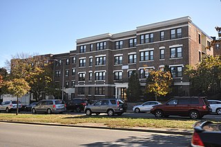
The Columbia Road–Strathcona Road Historic District encompasses a collection of brick residential apartment houses on Columbia and Strathcona Roads in the Roxbury neighborhood of Boston, Massachusetts. Arrayed on the southeast side of Columbia Road between Washington and Brinsley Streets are several multistory buildings with well-preserved Colonial Revival features. They were constructed in the first two decades of the 20th century, when the area was developed as a streetcar suburb. These were built mainly by Jewish developers Saul E. Moffie and Samuel Levy to serve a growing Jewish population in the area.


