Ashoknagar (also Ashok Nagar) is a city and a Municipality Council[10] in Ashoknagar District in Madhya Pradesh state of central India. It is the administrative headquarters of Ashoknagar District. Earlier it was part of Guna district. Ashoknagar is well known for its Grain Mandi and "Sharbati Gaihu", a type of wheat.[11] The nearest city Guna 45km from the city. Ashoknagar was formerly known as Pachar. The railway line passes from the middle of the city. Ashoknagar has a railway station and Two Bus stations. Ashoknagar is connected to the main cities of Madhya Pradesh by road and railway.
Ashoknagar is located in the northern part of Madhya Pradesh, between the rivers Sindh and the Betwa. It comes under the northern part of Malwa plateau, though main part of its district lies in the Bundelkhand Plateau. The eastern and western boundaries of the district are well defined by the rivers. The Betwa flows along the eastern boundary separating it from Sagar District and Lalitpur District, India of Uttar Pradesh. The Sindh is the main river flowing along the western boundary. Chanderi, a part of Ashoknagar, is famous for its brocades and muslins, especially for its handwoven Chanderi sarees. Ashoknagar is situated on the Kota-Bina railway section of Western Central Railway. Ashoknagar district has boundary to the border of UP in the east, about 87km from Lalitpur in Uttar Pradesh. Ashoknagar is approximately 190km away from the capital of the state Bhopal, 360km from Indore, 153km from Jhansi and about 250km from Gwalior.
Etymology
It is believed that Great Emperor Asoka, while on his trip to conquer Ujjain, had spent a night in Ashoknagar and hence the name.[12][13]
History
History of the town goes back around the ancient Indian Mahabharat, according to many early historians, Ashoknagar town was a part of Chedi Kingdom along with Chanderi.[citation needed]
Rather than this, In the 19th and early 20th century, the town being a part of Ishagarh District of Scindhiyas of Gwalior. In the late 20th century, Ashoknagar was known as PACHHAR. Later on it was renamed by MP government as Ashoknagar. Ashokanagar used to be a town of guna district. it became district in 2003.
The female-to-male ratio in Ashoknagar stands at 900 females per 1000 males compared to the 2001 census figure of 879 per 1000. The average national female-to-male ratio in India is 940 per 1000 as per latest reports of Census 2011 Directorate.
Culture
The city lies in the Bundelkhand region and follows traditional Indian culture. Ashoknagar is famous for the Jain temple called Trikaal Choubeese, where the idols of past, present, and future Thirthankars, as described in the Jain religion, have been kept. The district is also famous for a small town called 'Chanderi', which is about 60km from Ashoknagar. Chanderi was earlier, at the time of Mahabharata, known as "Chendi". Chendi Naresh Shishupal was its ruler, who was then killed by Lord Krishna[15] In Chanderi, ancient sculptures have been discovered in large numbers. Thubonji Sidhdha Kshetra is another one of the pilgrim center for Jains. It is about 32km from Ashoknagar. In the south, about 35km from Ashoknagar, is the famous Karila Mata Mandir, which is known to be the birthplace of Luv and Kush, sons of Lord Rama and Sita Mata. A huge fair is organized every year on Rangpanchmi in which the Rai Dance is performed by the Bedni women. Tumen is also a famous historical pilgrim center situated at Triveni known for Mata Vindhyavasini temple. There are many more places of religious importance in the district of Ashoknagar.
Chanderi is a tehsil of the Ashoknagar district and is a famous historical & tourist palace. The main occupation of the people of Chanderi is handicraft. Chanderi sarees are famous all over the world. These are made by cotton and silk by hand through Khatka. Khatka is a self made machine for preparing sarees. Another famous place in Ashoknagar district is Sri Anandpur, the world headquarters of the Sri Advaith Paramhansa Sect. Disciples from across the globe visit Anandpur twice a year during Baisakhi and Guru Purnima to seek blessings from the gurus. Kadwaya, a small village in the district is also famous for the ancient Shiv Mandir, Garhi and Mata Mandir.
Geography
Ashoknagar is situated at the average elevation of 507 metres(1640ft) above sea level. It is in the plateau region and has an agricultural topography. The plateau is an extension of the Deccan Traps, formed between 60 and 68 million years ago at the end of the Cretaceous period. In this region, the main classes of soil are black, brown and bhatori (stony) soil. The volcanic, clay-like soil of the region owes its black colour to the high iron content of the basalt from which it is formed. The soil requires less irrigation because of its high capacity for moisture retention. The other two soil types are lighter and have a higher proportion of sand. The year is popularly divided into three seasons: summer, the rains, and winter. Summer extends over the months of Chaitra to Jyestha (mid-March to mid-May). The average daily temperature during the summer months is 35°C, which typically rises to around 46°C on a few days. The rainy season starts with the first showers of Aashaadha (mid-June) and extends to the middle of Ashvin (September). Most of the rain falls during the southwest monsoon spell, and ranges from about 100cm in the west to about 165cm in the east. Ashoknagar and surrounding areas receive an average of 140cm of rainfall a year. The growing period lasts from 90 to 150 days, during which the average daily temperature is below 30°C, but seldom falls below 20°C. Winter is the longest of the three seasons, extending for about five months (mid-Ashvin to Phalgun, i.e., October to mid-March). The average daily temperature ranges from 15°C to 20°C, though on some nights it can fall as low as 5°C. Some cultivators believe that an occasional winter shower during the months of Pausha and Maagha—known as Mawta—is helpful to the early summer wheat and germ crops.[5]
Climate
The climate of Ashoknagar is sub-tropical. In summers, the temperature reaches 47°C, while dropping to 4°C in the winter. Rainfall is adequate and sometimes less.
There are a number of tourist spots in Ashoknagar Town, including: vindyvashni temple and many other temple here tumen
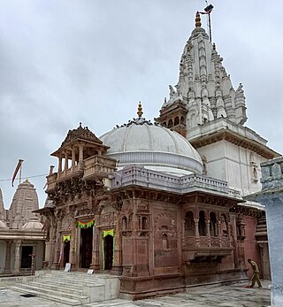
Jain Temples
Ashoknagar district is one of the largest district on the basis of Jain population in India after Sagar, Tikamgarh, and Lalitpur. The Seven Super designed Jain Temples lie in the center of the Town. These are:
Tulsi Sarovar – Huge natural water lake. Boating at evening.
Amai Dam
Sankat Mochan
There are four Temples of lord Hanumana lies at all four Outskirts of the main city.
Shri Taare Waale Balaji Temple in Aajad Mohalla
Nehru Bal Udhyan
Tulsi Sarovar Park
Along with the above-mentioned locations, there are many other tourist spots in the outskirts of Ashoknagar.
Chanderi
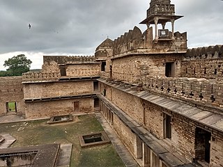
The Chanderi Fort is situated on a hill 71 meters above the town. The fortified walls were constructed mainly by the Muslim rulers of Chanderi. The main entrance to the fort is through a series of three gates, the uppermost of which is known as Hawa Paur and the lowermost is called the Khuni Darwaja, or the gate of blood. The peculiar name is derived from the fact that criminals were executed at this point by hurling them from the battlements above, breaking their bodies into pieces to the ground. Within the fort there are only two ruined buildings: the Hawa and Nau-Khanda Mahals built by Bundela Chiefs. A rest house on the northern ridge provides a view of the town below by the countryside.
Chanderi Fort
To the southwest of Fort there is a curious gateway called katti-ghatti built through the hillside. It is 59 meters long, 12 meters broad and 24.6 meters high. In its center, the rock has been sculpted into the shape of a gate, with a pointed arch, and flanked by sloping towers.
Kaushak Mahal
The Kaushak Mahal of Chanderi is also known as Tawarikh-i-Ferishta. According to history, in 1445 AD Mehmood Shah Khilji of Malwa was passing through Chanderi, when he ordered a seven-storied palace to be built there, which came to be Kaushak Mahal. It is an imposing building of some grandeur, though standing in a half-ruined condition. To the south, east and north of the Kaushak Mahal, well maintained palaces of Ramnagar, Panchamnagar and Singhpur are situated respectively. All were built by Bundela chiefs of Chanderi in the 18th century.
Shri Anandpur
Shri Anandpur is a religious place, which is the part of Issagarh Tehsil, about 30km from the district center of Ashoknagar. The institution is influenced by "Advait Mat". The founder of this institution was Shri Advait Anand Ji. He is also known as Maharaj Shri Paramhans Dayal Ji. The place is surrounded with greenery. The Ashram is situated near Vindhyachal Mountain range and is the center of attraction for its glorious architecture and pollution free environment. The development of Anandpur started away back in 1939 and continued till 1964. The institution was established as " Shri Anandpur Trust" on 22 April 1954 and this trust is running a charity hospital which is a main attraction point for the locals where they can get good medical facility free. Most of its development took place during Shri Padshahi Ji Maharaj IV & Shri Padshahi Ji Maharaj V. Shri Anand Shanti Bhavan is the main part of the sacred place, is constructed with pure white marble. The pillar can be seen from a long distance away from the building. The Satsang Bhavan is a huge place of Shri Anandpur. It is the centre of attraction for the devotees. In Shri Anandpur the facilities of Hospital, School, Post Office etc. are present too.
Kadwaya
Kadwaya a small village of ISAGARH tehsil of district ashoknagar having number of temples. One of these temples has been constructed in the 10th century in Kachhapaghata style of architecture. It has garbha-griha (sanctum), antaral and mandapa. Another old temple of Kadwaya is known as Chandal math. As per history, it was built to house Matta Mourya, members of Shaiva sect. During Akbar's reign Kadwaya was the headquarters of Gwalior's sarkar. Kadwaya is alSo the birthplace of pandit late ramvali sharma who served till death for the socio, political and economic development of the village. Besides this KADWAYA GADI(buried fort) is the site of world heritage. it is also famous for mata BIJASEN TEMPLE. it is said that one cures there defected eyes, by her blessings. total population of kadwaya is approx. 3000.
Thubonji Sidhdha Kshetra
In Thubonji Sidhdha Kshetra, there are a group of 26 temples imparting the message of peace, nonviolence & non-affection ness to pilgrims. This sacred place Thuvonji came to knowledge during the period of famous businessman Padashah. It is believed that when Padashah put his metal Tin here, it got converted into Silver. Temple No. 15 is the main among them known as big temple, with 28 feet high miraculous colossus of Lord Adinath in standing posture, installed by Vikram Samvat in 1672.
Atishay – It is said that sound of various musical instruments is heard at the night as the gods from heaven come here for prayers & worships. It is also said that after the completion of this high colossus, initially devotees were unable to install it in the standing posture. At that night, Head of the Construction saw a dream that worshipping the colossus will only allow it to be installed in the standing posture, accordingly in the next morning colossus was worshipped and then Head of the Construction alone was able to place the high colossus in standing posture. The public present at that time saw this miracle with wonder.
There are number of Jain temples are also present in the Kshetra:
Lord parsvanath Jain Temple – There is a magnificent 15 feet high colossus of Lord Parsvanath (23rd Teerthankar) installed in V.S. 1864. The colossus have a very artistic serpent hood over the head as well as in both the sides of the colossus.
Lord Shantinath Jain temple – 18 feet high standing posture of Lord Shantinath (16th Teerthankar) is the principal deity in the temple.
Ajitnath Jain Temple – Principal deity is the Lord Ajitnath(2nd Teerthankar).
Adinath Jain Temple – It is also a magnificent and vast temple having 16 feet high colossus of Lord Adinath. This was installed by Savasingh of Chanderi in V.S. 1873. He also completed the famous Choubeesee Mandir of Chanderi
Chandraprabhu Jain Temple – Lord Chandraprabhu (8th Teerthankar) is the principal deity in the temple, 1.5 feet sitting(Padmasana) statue of the Lord is the idol in the temple.
Museum – Some ancient idols are kept there, among them a standing 12 feet high idol.
Employment
In Ashoknagar, the occupation of the people is mostly agricultural. People are associated with grain merchandising. Textiles business is also very active. In recent times, Commodity Exchange Market has also grown along with logistic business. Ashok Nagar is famous for its market which includes textiles, Automobiles, Utensils, Cement works, Groceries, Gold and Ornaments and almost all other things. It is a business hub, people from all around the division come over here for the trade.
The roads inside the city are however quite wide, but are not in good paved condition.[citation needed] Thus, during rainy seasons there is a chance of lot of accidents occurring.[citation needed] A major issue is of the dust on the city's roads, it is such that there is a great chance of spreading diseases like severe cough and a lot more dust causing diseases.[citation needed]
Ashoknagar is situated on the state highway 20 (SH 20) with local connections to Guna, SH 10 to Vidisha and Shivpuri and connections on to Indore, Bhopal and Gwalior. SH 20 as GUNA-ISHAGARH road towards north, is about 3km inside the city, while SH 19 is about a single km at thobon/Chanderii road. Rather than this, There are some shorter city roads are also has links to nearer villages and towns, such as Pachaadi Kheda Road, Mohri road, Aron road, Kolua road, Pawargarh road, Kabira road etc.
Ashoknagar is 44km from the NH-3 Agra Bombay highway and one hour drive away from the NH-76.
Related Research Articles
Osmanabad District, officially known as Dharashiv District, is an administrative district in the Marathwada region in the Indian state of Maharashtra. The district headquarter is located at Osmanabad. The District of Osmanabad derives its name from the last ruler of Hyderabad, the 7th Nizam, Mir Osman Ali Khan, of which the region was a part till 1947. This region was earlier part of The Hyderabad State until Independence.This primarily rural district occupies an area of 7,569 km2 (2,922 sq mi) of which 241.4 km2 (93.2 sq mi) is urban and has a population of 1,657,576 of which 16.96% were urban.
Chanderi, is a town of historical importance in Ashoknagar District of the state Madhya Pradesh in India. It is situated at a distance of 127 km from Shivpuri, 37 km from Lalitpur, 55 km from Ashok Nagar and about 46 km from Isagarh. It is surrounded by hills southwest of the Betwa River. Chanderi is surrounded by hills, lakes and forests and is spotted with several monuments of the Bundela Rajputs and Malwa sultans. It is famous for ancient Jain Temples. Its population in 2011 was 33,081.
Guna district is one of the 52 districts of Madhya Pradesh in central India. Its administrative headquarters is Guna. The district has a population of 1,241,519. It has an area of 6390 km², and is bounded on the northeast by Shivpuri District, on the east by Ashoknagar District, on the southeast by Vidisha District, on the southwest by Rajgarh District, on the west and northwest by Jhalawar and Baran districts of Rajasthan state. The Sindh River flows northward along the eastern edge of the district, forming part of the boundary with Ashoknagar District, and the Parvati River flows northwestward through the southern portion of the district, forming part of the boundary with Baran District before flowing into Rajasthan.
Ashoknagar District is a district of Madhya Pradesh state in central India. The city of Ashoknagar is the administrative headquarters of the district. Ashoknagar district was formed in 2003.
Lalitpur is one of the 75 districts in the northern Indian state of Uttar Pradesh. Lalitpur district is a part of Jhansi Division. Lalitpur is the main town and administrative headquarters. The district occupies an area of 5,039 km2.
Shivpuri District is a district of Madhya Pradesh state of India. The town of Shivpuri is the district headquarters. National Highway 3 (NH-3) runs through the district.
Jainism has been present in Maharashtra since ancient times. The famous Ellora Caves demonstrate that Jainism was part of a thriving religious culture in Maharashtra in premodern times.
Mangi-Tungi is a prominent twin-pinnacled peak with plateau in between, located near Tahrabad about 125 km from Nashik, Maharashtra, India. Mangi, 4,343 ft (1,324 m) high above sea level, is the western pinnacle and Tungi, 4,366 ft (1,331 m) high, the eastern. Mangi-Tungi is 30 km (19 mi) from the city of Satana.
Bijoliya is a census town in Bhilwara district in the state of Rajasthan, India and is surrounded by nature and waterfalls and is famous for Tapodaya Teerth Kshetra and Mandakini Temple.
Jintur city and a municipal council in Parbhani district in the Indian state of Maharashtra.
Karera is a municipality or Nagar Parishad in the Shivpuri district of the Indian state of Madhya Pradesh.
Maksi is a city and a municipality in Shajapur district in the Indian state of Madhya Pradesh. It is famous for Jain Temple of Maksi Parshwanathh Ji. Maksi has an ever buzzing market which is famous for sweet samosas.
Pichhore is a town and a nagar panchayat in Shivpuri district in the Indian state of Madhya Pradesh.It is Also linked with Train route from Basai railway station situated 35 km from Pichhore.Also it is situated in Bundelkhand region of MP.
Rawan Urf Bada Gaon is a village near Khekra, a town in the district of Bagpat, Uttar Pradesh. It is famous for Maa Mansa Devi Temple, This Temple was established by Ravana. It is historic and one of the oldest temple in baghpat. It is also famous for Digambar Jain Mandir.
Along with it in badagaon there is a Shri Parshwanath Atishaya Kshetra Prachin Digambar Jain Mandir that houses an idol of Lord Parshvanath, the 23rd Tirthankara of Jainism and the Trilok Teerth Dham Mandir.
Chanderi Assembly constituency is one of the 230 Vidhan Sabha constituencies of Madhya Pradesh state in central India. This constituency came into existence in 2008, following the delimitation of the Legislative Assembly constituencies.
Aharji is a historical pilgrimage site for Jainism in India. It is located in the central Indian state of Madhya Pradesh, on the road from Tikamgarh to Chhatarpur. This place is famous for Jain Temple.
Shadora is A town and tehsil in Ashoknagar district in the Indian state of Madhya Pradesh. It is situated on the Bina-Kota railway line. Its std code is 07543 and pin code is 473330. Shadora is well known for its Narayan das story and famous Hanuman tekeri temple. Shadora, formerly known as city of Narayan das. The railway line is in the separate side of the city. Shadora has a Railway station and Bus stand. Shadora is connected to the main cities of M.P. by the means of road.
Atishay Kshetra Lunwa is a famous Jain pilgrimage site situated 70 km from Jaipur. Lunwa is a small village in the Nagaur district of Rajasthan, India. The temple, one of two Jain temples in Lunwa, was established in 1672. लूणवा जैन मंदिर मेंथा पर अवस्थित है
Navagarh is a Jain Tirth in India. It is located at the Nabai village near Sojna in central India in Uttar Pradesh, just across the border from Madhya Pradesh. It is 65 km east from Lalitpur and 110 km north from Sagar. This ancient cite was excavated in 1959. It is the only tirth in India where the main deity is the ancient image of Lord Aranatha, preserved in the ancient underground chamber.
This page is based on this Wikipedia article Text is available under the CC BY-SA 4.0 license; additional terms may apply. Images, videos and audio are available under their respective licenses.