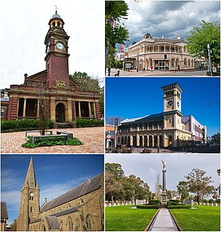
Maitland is a city in the Hunter Valley of New South Wales, Australia and the seat of Maitland City Council, situated on the Hunter River approximately 166 kilometres (103 mi) by road north of Sydney and 35 km (22 mi) north-west of Newcastle. It is on the New England Highway approximately 17 km (11 mi) from its origin at Hexham.

Balgowlah is a suburb of northern Sydney, in the state of New South Wales, Australia. Balgowlah said to be an Aboriginal name for "North Harbour". The area now known as Balgowlah was known to the Aboriginals as Jilling.
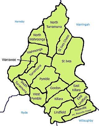
St Ives is a suburb on the Upper North Shore of Sydney in the state of New South Wales, Australia 18 kilometres north of the Sydney Central Business District in the local government area of Ku-ring-gai Council. St Ives Chase is a separate adjacent area, designated suburb, to the west and north.
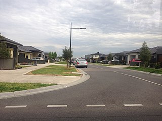
Craigieburn is a suburb in Melbourne, Victoria, Australia, 25 km (16 mi) north of Melbourne's Central Business District, located within the City of Hume local government area. Craigieburn recorded a population of 65,178 at the 2021 census.

Baulkham Hills is a suburb in the Hills District of Greater Sydney, in the state of New South Wales, Australia. It is located within 30 kilometres north-west of the Sydney central business district mostly within the local government area of The Hills Shire, of which Baulkham Hills was formerly the administrative seat and namesake of The Hills Shire. A small section of the suburb which is located south of the Hills Motorway-Windsor Road intersection is part of the City of Parramatta.

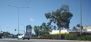
Sunnybank Hills is an outer southern suburb in the City of Brisbane, Queensland, Australia. In the 2021 census, Sunnybank Hills had a population of 18,085 people.

Sefton is a suburb in Western Sydney, Australia. It is located 23 kilometres west of the Sydney central business district, in New South Wales, Australia. It shares the 2162 postcode with the neighbouring suburb of Chester Hill.

Macquarie Park is a suburb in the Northern Sydney region of Sydney, New South Wales, Australia. Macquarie Park is located 13 kilometres north-west of the Sydney central business district in the local government area of the City of Ryde.

Cardiff is a small town in the Lake Macquarie LGA of New South Wales, Australia.

Kenthurst is a suburb of Sydney, in the state of New South Wales, Australia 39 kilometres north-west of the Sydney central business district in the local government area of The Hills Shire. It is part of the Hills District region.

Thornton railway station is located on the Main Northern line in New South Wales, Australia. It serves Thornton in the eastern suburbs of Maitland opening in 1913.
Speers Point is a suburb of Greater Newcastle, and the location of the council seat of the City of Lake Macquarie local government area in New South Wales, Australia. It is 17 kilometres (10.6 mi) west-southwest of the city of Newcastle on the northern shore of Lake Macquarie, in Cockle and Warners Bays, between the suburbs of Cardiff and Warners Bay.

Greta is a small town in the Hunter Region of New South Wales, Australia.

Boambee is a suburb in the city of Coffs Harbour on the Mid North Coast of New South Wales, Australia. Boambee is west of Sawtell on the Pacific Highway. It is divided into two sections: semi-rural Boambee (2450) and the more suburban Boambee East (2452). These suburbs are divided by the Pacific Highway. In 2011, Boambee had a population of 1,545 people, while Boambee East had a population of 5,446 people.
Thornton is a suburb in the City of Maitland, New South Wales, Australia. It is bisected by the New England Highway.
East Maitland is a suburb in Maitland, New South Wales, Australia. It is on the New England Highway and it has two railway stations, Victoria Street and East Maitland. Both stations are served by NSW TrainLink. Hunter Valley Buses provides bus service.

Tarro is a north-western suburb of the Newcastle City Council local government area in the Hunter Region of New South Wales, Australia. It, and parts of nearby Beresfield, was originally known as Upper Hexham, "lower" Hexham being an older settlement located about 5 kilometres (3 mi) to the east on the Hunter River. The name "Tarro" reportedly means "stone" in an Aboriginal language.
Stockland Green Hills, formerly Green Hills Shopping Centre, is a large indoor/outdoor shopping centre located in East Maitland, New South Wales, Australia.
Chisholm is a suburb in the City of Maitland, New South Wales, Australia. It is 23 kilometres (14 mi) north-northwest from Newcastle, and 7 kilometres (4 mi) south-east from Maitland. The traditional owners and custodians of the Maitland area are the Wonnarua people.
Earlville is a suburb of Cairns in the Cairns Region, Queensland, Australia. In the 2016 census, Earlville had a population of 4,030 people.
